


A New Largest Ski Area in New Zealand?
The Remarkables is hoping to overtake Cardrona as New Zealand’s largest ski area under a major NZD 150 million‑plus expansion proposal lodged by owner NZSki.

Next 3 days weather summary:Heavy rain (total 41.0mm), heaviest during Fri morning. Very mild (max 17°C on Sat afternoon, min 13°C on Fri night). Wind will be generally light. | Days 4-6 weather summary:Light rain (total 6.0mm), mostly falling on Tue afternoon. Warm (max 20°C on Tue afternoon, min 15°C on Sun morning). Wind will be generally light. | |||||||||||||||||
Thursday 25 | Friday 26 | Saturday 27 | Sunday 28 | Monday 29 | Tuesday 30 | |||||||||||||
AM | PM | night | AM | PM | night | AM | PM | night | AM | PM | night | AM | PM | night | AM | PM | night | |
cloudy | cloudy | heavy rain | heavy rain | mod. rain | light rain | some clouds | some clouds | some clouds | cloudy | rain shwrs | rain shwrs | some clouds | some clouds | clear | rain shwrs | t-storm risk | some clouds | |
km/h | ||||||||||||||||||
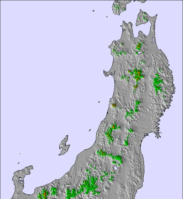
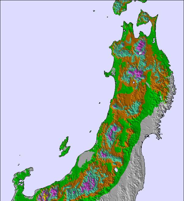
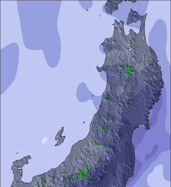
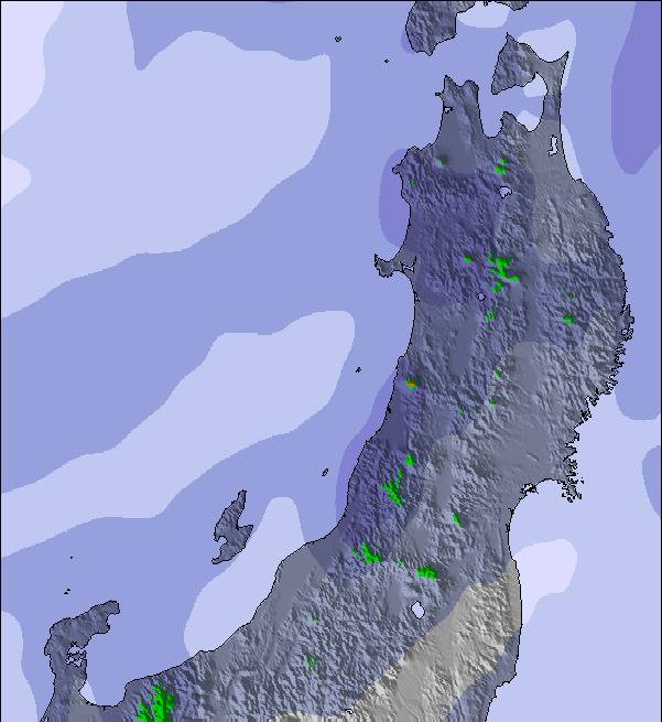
Snow map | 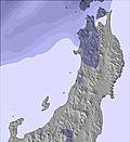 | 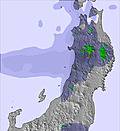 | 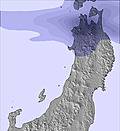 | 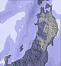 | 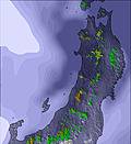 | 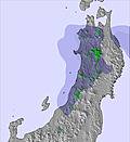 | ||||||||||||
— | — | — | — | — | — | — | — | — | — | — | — | — | — | — | — | — | — | |
mm | — | — | 17 | 14 | 6 | 4 | — | — | — | — | 1 | 1 | — | — | — | 1 | 3 | — |
max °C | 15 | 15 | 15 | 16 | 16 | 15 | 16 | 17 | 16 | 17 | 17 | 16 | 18 | 18 | 17 | 19 | 20 | 17 |
min °C | 15 | 15 | 14 | 15 | 15 | 13 | 14 | 17 | 15 | 15 | 17 | 15 | 16 | 18 | 16 | 17 | 18 | 16 |
chill °C | 14 | 14 | 13 | 14 | 14 | 12 | 14 | 17 | 15 | 15 | 17 | 15 | 16 | 18 | 16 | 17 | 18 | 16 |
Humid % | 82 | 79 | 91 | 95 | 90 | 91 | 92 | 81 | 90 | 77 | 74 | 79 | 64 | 57 | 81 | 83 | 70 | 84 |
Freeze m | 4250 | 4300 | 4550 | 4400 | 4300 | 3900 | 4550 | 4700 | 4800 | 4600 | 4400 | 4250 | 4250 | 4250 | 4200 | 4250 | 4250 | 4300 |
4:28 | — | — | 4:28 | — | — | 4:28 | — | — | 4:30 | — | — | 4:30 | — | — | 4:31 | — | — | |
— | 7:09 | — | — | 7:09 | — | — | 7:09 | — | — | 7:09 | — | — | 7:09 | — | — | 7:09 | — | |
Go pro and carve into:
Avalanche information: Japan Avalanche Network
Latest snow reports near Myoko Suginohara:
Partly cloudy at Tsugaike Kogen. No wind here. Mild temperatures. No fresh snow. Lifts are closed. No pistes are open. from Tsugaike Kogen
| Top snow depth: | — |
|---|---|
| Bottom snow depth: | — |
| Fresh snowfall depth: | — |
| Last snowfall: | 4 May 2026 |
| Snow Alerts | Create Alert |
0.0 | Bluebird Powder days Fresh snow, mostly sunny, light wind. |
|---|---|
0.0 | Powder days Fresh snow, limited sun, any wind. |
0.0 | Bluebird days Average snow, mostly sunny, light wind. |


The above table gives the weather forecast for Myoko Suginohara at the specific elevation of 1293 m. Our sophisticated weather models allow us to provide snow forecasts for the top, middle and bottom ski stations of Myoko Suginohara. To access the weather forecasts for the other elevations, use the tab navigation above the table. For a wider view of the weather, check out the Weather Map of Japan.
Click here to read further information on freezing levels and how we forecast our temperatures.
Overall 3.0 Based on 5 votes and 2 reviews
Suginohara only has 5 lifts, but the main gondala is about 2.7 Km long and there are two modern 4 man chairs each 1.7 Km. These open up long intermediate runs, with plenty of runs through the trees. There is a well maintained park area on the extreme left. Views are quite spectacular. From top to bottom is an unbroken 8.5 Km run dropping about 1000 meters. The short 2 man chair back to the gondola must be one of the slowest in the world. Free shuttle bus from and to Myoko Kogen Yodel Information Centre. Good day out. The 5 consecutive hours lift ticket looks good value. If line for tickets is long ski down to gondola station and buy ticket there.
Dr Gordon Caldwell from United Kingdom writes:
Suginohara only has 5 lifts, but the main gondala is about 2.7 Km long and there are two modern 4 man chairs each 1.7 Km. These open up long intermediate runs, with plenty of runs through the trees. There is a well maintained park area on the extreme left. Views are quite spectacular. From top to bottom is an unbroken 8.5 Km run dropping about 1000 meters. The short 2 man chair back to the gondola must be one of the slowest in the world. Free shuttle bus from and to Myoko Kogen Yodel Information Centre. Good day out. The 5 consecutive hours lift ticket looks good value. If line for tickets is long ski down to gondola station and buy ticket there.

 Nearest