


Global Weekly Snow Roundup #320
Weekly Snow News for the world, updated 25 June 2026: Chile and New Zealand's seasons proper set to begin, Tignes and Sunshine reopen for summer skiing. weekend as Riksgransen ends its 2026 season.

Next 3 days weather summary:Mostly dry. Freeze-thaw conditions (max 5°C on Mon morning, min -1°C on Sat night). Winds increasing (calm on Sat morning, strong winds from the NNW by Mon night). | Days 4-6 weather summary:Moderate rain (total 14.0mm) heaviest on Wed night, then becoming colder with a dusting of snow on Thu night. Mild temperatures (max 5°C on Tue morning, min 1°C on Thu night). Winds increasing (moderate winds from the NW on Tue night, gales from the NNW by Thu night). | |||||||||||||||||
Saturday 27 | Sunday 28 | Monday 29 | Tuesday 30 | Wednesday 1 | Thursday 2 | |||||||||||||
AM | PM | night | AM | PM | night | AM | PM | night | AM | PM | night | AM | PM | night | AM | PM | night | |
some clouds | some clouds | clear | clear | clear | clear | some clouds | cloudy | cloudy | cloudy | light rain | some clouds | cloudy | cloudy | mod. rain | some clouds | rain shwrs | light snow | |
km/h | ||||||||||||||||||
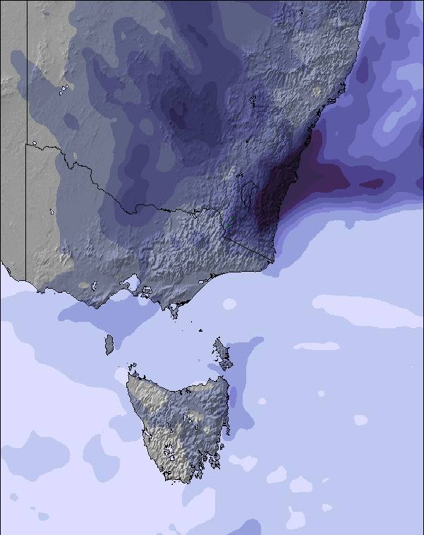
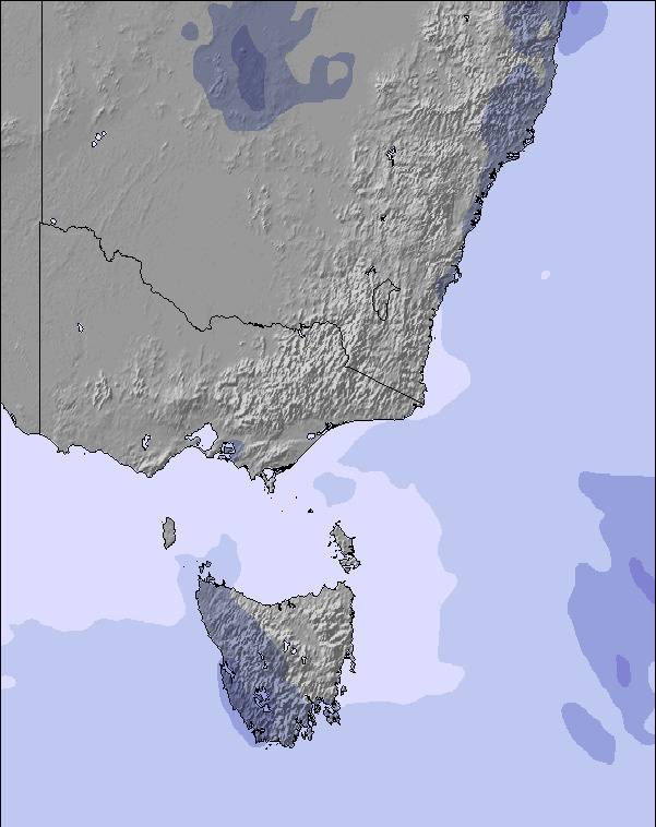
Snow map | 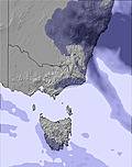 | 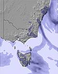 | 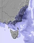 | 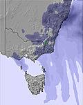 | 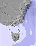 | 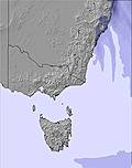 | ||||||||||||
— | — | — | — | — | — | — | — | — | — | — | — | — | — | — | — | — | 1 | |
mm | — | — | — | — | — | — | — | — | — | — | 1 | — | — | — | 9 | — | 1 | 3 |
max °C | 3 | 2 | -1 | 4 | 2 | 1 | 5 | 3 | 3 | 5 | 5 | 4 | 5 | 5 | 4 | 5 | 4 | 3 |
min °C | 1 | 0 | -1 | 2 | 0 | 0 | 3 | 3 | 2 | 4 | 5 | 4 | 5 | 5 | 3 | 3 | 3 | 1 |
chill °C | 1 | -2 | -4 | -1 | -6 | -6 | -3 | -3 | -5 | -2 | 0 | -1 | 0 | -1 | -3 | -4 | -3 | -6 |
Humid % | 69 | 58 | 64 | 42 | 61 | 65 | 79 | 92 | 87 | 97 | 93 | 85 | 89 | 90 | 96 | 93 | 82 | 99 |
Freeze m | 1450 | 1650 | 1550 | 1950 | 1850 | 1950 | 1900 | 1900 | 2050 | 2150 | 2200 | 2250 | 2150 | 2150 | 2100 | 1950 | 1900 | 1700 |
7:45 | — | — | 7:45 | — | — | 7:45 | — | — | 7:45 | — | — | 7:43 | — | — | 7:43 | — | — | |
— | 4:47 | — | — | 4:47 | — | — | 4:49 | — | — | 4:49 | — | — | 4:50 | — | — | 4:50 | — | |
Go pro and carve into:
Avalanche information: Avalanche Australia
Latest snow reports near Mount Mawson:
| Top snow depth: | — |
|---|---|
| Bottom snow depth: | — |
| Fresh snowfall depth: | — |
| Last snowfall: | 19 Jun 2026 |
| Snow Alerts | Create Alert |
0.4 | Bluebird Powder days Fresh snow, mostly sunny, light wind. |
|---|---|
0.4 | Powder days Fresh snow, limited sun, any wind. |
0.3 | Bluebird days Average snow, mostly sunny, light wind. |
The above table gives the weather forecast for Mount Mawson at the specific elevation of 1230 m. Our sophisticated weather models allow us to provide snow forecasts for the top, middle and bottom ski stations of Mount Mawson. To access the weather forecasts for the other elevations, use the tab navigation above the table. For a wider view of the weather, check out the Weather Map of Australia.
Click here to read further information on freezing levels and how we forecast our temperatures.
Overall 2.3 Based on 8 votes and 1 review
Mawson is worth a look when there is decent snow. It has a character that is missing from all other Australian resorts. Its snowfalls are unpredictable, but when wet/cold systems go through it can snow and accumulate heaps. The runs are not groomed. University is green, Mawson run is blue, Rodway most definitly black, the right side of Rodway Tow is double black. Some inexperienced skiers may have difficulty coping with Mawson, unless the snow cover was quite extensive and they can handle the novelty of the nutcrackers. Rodway is the best run in Tas, and the unpatrolled run down the Golden Stairs (back to the car) is exhilerating. That said people who can cope with skiing Mawson, its moguls, the obstacles, turn on a dime whilst carving, etc., can become very very good skiers. But it needs good snow, this seems to be becoming the exception rather than the rule. Mawson usually gets going first (needs 60 cm of snow), then Uni (needs (60-90 cm), then Rodway. Rodway didn't run in 2007, it needs about a metre of snow, most of it is actually bushes (not rocks) so it does flatten down. Rodway has to have trained volunteers to run it, if it does go, it usually operates for about 3-4 hours plus a lunch break (this is unique to Mawson), which is enough to make you well and truly stuffed, remember no queues, just going up and down. In the right snow conditions, with all tows running, Mawson is a great place, but you need to go when its there.
Jamie from Australia writes:
Mawson is worth a look when there is decent snow. It has a character that is missing from all other Australian resorts. Its snowfalls are unpredictable, but when wet/cold systems go through it can snow and accumulate heaps.
The runs are not groomed. University is green, Mawson run is blue, Rodway most definitly black, the right side of Rodway Tow is double black. Some inexperienced skiers may have difficulty coping with Mawson, unless the snow cover was quite extensive and they can handle the novelty of the nutcrackers. Rodway is the best run in Tas, and the unpatrolled run down the Golden Stairs (back to the car) is exhilerating.
That said people who can cope with skiing Mawson, its moguls, the obstacles, turn on a dime whilst carving, etc., can become very very good skiers. But it needs good snow, this seems to be becoming the exception rather than the rule.
Mawson usually gets going first (needs 60 cm of snow), then Uni (needs (60-90 cm), then Rodway. Rodway didn't run in 2007, it needs about a metre of snow, most of it is actually bushes (not rocks) so it does flatten down. Rodway has to have trained volunteers to run it, if it does go, it usually operates for about 3-4 hours plus a lunch break (this is unique to Mawson), which is enough to make you well and truly stuffed, remember no queues, just going up and down.
In the right snow conditions, with all tows running, Mawson is a great place, but you need to go when its there.


 Nearest