

Global Weekly Snow Roundup #320
Weekly Snow News for the world, updated 25 June 2026: Chile and New Zealand's seasons proper set to begin, Tignes and Sunshine reopen for summer skiing. weekend as Riksgransen ends its 2026 season.

Next 3 days weather summary:Heavy rain (total 38.0mm), heaviest during Wed night. Later becoming colder with a dusting of snow on Wed night. Mild temperatures (max 6°C on Wed night, min 1°C on Wed night). Winds increasing (fresh winds from the N on Mon morning, gales from the NW by Wed night). | Days 4-6 weather summary:A moderate fall of snow, heaviest on Thu afternoon. Freeze-thaw conditions (max 2°C on Thu morning, min -3°C on Thu night). Winds decreasing (stormy winds from the NNW on Thu morning, fresh winds from the SSW by Sat night). | |||||||||||||||||
Monday 29 | Tuesday 30 | Wednesday 1 | Thursday 2 | Friday 3 | Saturday 4 | |||||||||||||
AM | PM | night | AM | PM | night | AM | PM | night | AM | PM | night | AM | PM | night | AM | PM | night | |
light rain | light rain | light rain | mod. rain | light rain | light rain | light rain | mod. rain | light snow | cloudy | light snow | light snow | light snow | light snow | light snow | light snow | light snow | light snow | |
km/h | ||||||||||||||||||
Snow map | 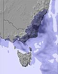 | 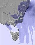 | 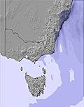 | 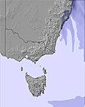 | 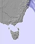 | 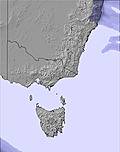 | ||||||||||||
— | — | — | — | — | — | — | — | 3 | — | 5 | 3 | 1 | — | 3 | 1 | 1 | 1 | |
mm | 1 | 1 | 4 | 6 | 4 | 1 | 2 | 7 | 12 | — | — | — | — | — | — | — | — | — |
max °C | 3 | 4 | 5 | 5 | 5 | 4 | 4 | 4 | 6 | 2 | 2 | -2 | -1 | -1 | -1 | -3 | -2 | -2 |
min °C | 3 | 4 | 4 | 5 | 5 | 4 | 3 | 4 | 1 | 2 | 0 | -3 | -2 | -1 | -3 | -3 | -2 | -3 |
chill °C | -3 | -2 | -2 | -2 | -2 | -2 | -4 | -3 | -8 | -7 | -8 | -13 | -12 | -11 | -13 | -13 | -11 | -12 |
Humid % | 94 | 94 | 96 | 98 | 95 | 84 | 90 | 93 | 84 | 79 | 92 | 96 | 96 | 87 | 91 | 97 | 98 | 97 |
Freeze m | 2100 | 2400 | 2450 | 2500 | 2500 | 2350 | 2200 | 2400 | 1950 | 2250 | 1800 | 1200 | 1250 | 1300 | 1050 | 1050 | 1200 | 1150 |
7:31 | — | — | 7:31 | — | — | 7:31 | — | — | 7:31 | — | — | 7:31 | — | — | 7:31 | — | — | |
— | 5:05 | — | — | 5:05 | — | — | 5:05 | — | — | 5:06 | — | — | 5:06 | — | — | 5:07 | — | |
Go pro and carve into:
Avalanche information: Avalanche Australia
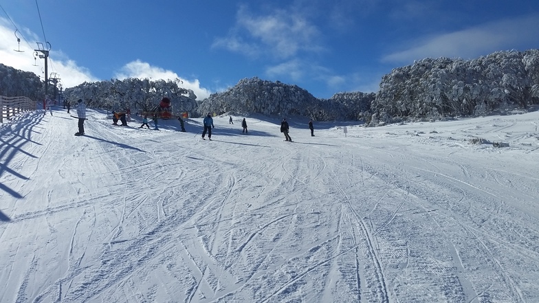
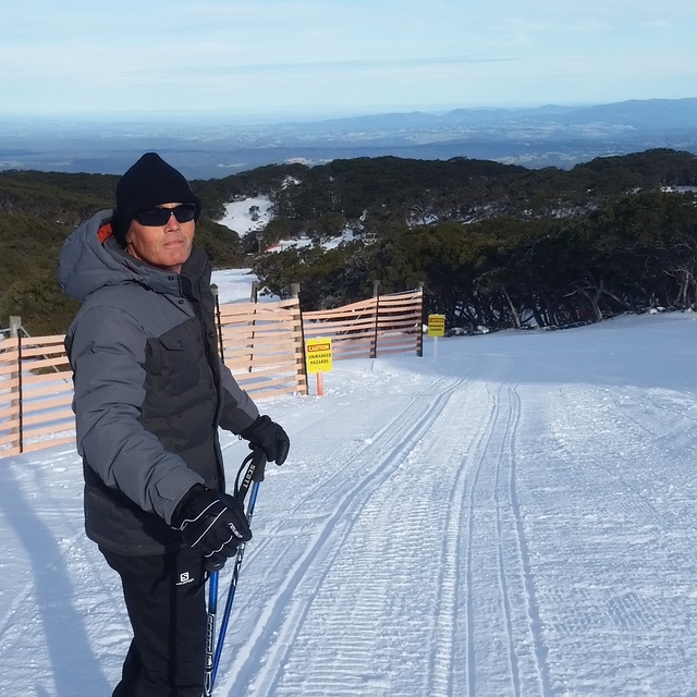
Latest snow reports near Mount Baw Baw:
| Top snow depth: | — |
|---|---|
| Bottom snow depth: | — |
| Fresh snowfall depth: | — |
| Last snowfall: | 20 Jun 2026 |
| Snow Alerts | Create Alert |
0.4 | Bluebird Powder days Fresh snow, mostly sunny, light wind. |
|---|---|
0.4 | Powder days Fresh snow, limited sun, any wind. |
0.3 | Bluebird days Average snow, mostly sunny, light wind. |

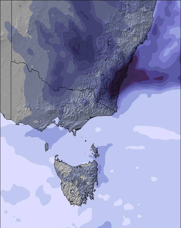
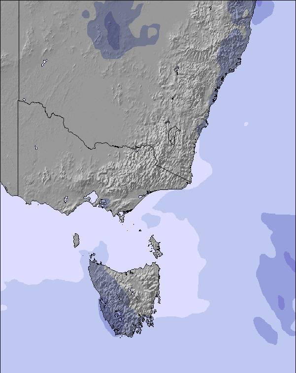
The above table gives the weather forecast for Mount Baw Baw at the specific elevation of 1560 m. Our sophisticated weather models allow us to provide snow forecasts for the top, middle and bottom ski stations of Mount Baw Baw. To access the weather forecasts for the other elevations, use the tab navigation above the table. For a wider view of the weather, check out the Weather Map of Australia.
Click here to read further information on freezing levels and how we forecast our temperatures.
Overall 3.4 Based on 5 votes and 2 reviews
I've had a great couple of seasons working at Mt. Baw Baw as a ski-instructor and working in the skihire from Franz Reiter. Nice mountain especially for families. We did have a lot of fun with the school groups as well. We hope to be back in 2005 again :-) Cu than and there!!!
Connie Huibregtse from Netherlands writes:
I've had a great couple of seasons working at Mt. Baw Baw as a ski-instructor and working in the skihire from Franz Reiter.
Nice mountain especially for families.
We did have a lot of fun with the school groups as well.
We hope to be back in 2005 again :-)
Cu than and there!!!


 Nearest