


Global Weekly Snow Roundup #320
Weekly Snow News for the world, updated 25 June 2026: Chile and New Zealand's seasons proper set to begin, Tignes and Sunshine reopen for summer skiing. weekend as Riksgransen ends its 2026 season.

Next 3 days weather summary:Mild with moderate rain (total 16.0mm) on Fri afternoon, Becoming colder with a light covering of snow, mostly falling on Sun night. Mild temperatures (max 7°C on Fri morning, min 1°C on Sat night). Winds increasing (light winds from the WNW on Sat morning, strong winds from the WNW by Sun night). | Days 4-6 weather summary:Moderate rain (total 11.0mm), heaviest on Mon morning. Very mild (max 10°C on Tue afternoon, min 2°C on Mon morning). Winds decreasing (fresh winds from the NW on Mon morning, calm by Mon night). | |||||||||||||||||
Friday 26 | Saturday 27 | Sunday 28 | Monday 29 | Tuesday 30 | Wednesday 1 | |||||||||||||
AM | PM | night | AM | PM | night | AM | PM | night | AM | PM | night | AM | PM | night | AM | PM | night | |
light rain | mod. rain | light rain | light rain | light rain | light rain | light snow | light snow | mod. snow | light rain | light rain | some clouds | clear | rain shwrs | rain shwrs | light rain | rain shwrs | light rain | |
km/h | ||||||||||||||||||
Snow map | 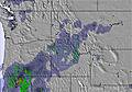 | 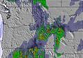 | 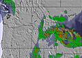 |  |  |  | ||||||||||||
— | — | — | — | — | — | — | — | 7 | — | — | — | — | — | — | — | — | — | |
mm | 1 | 6 | 3 | 1 | 2 | 2 | 1 | — | — | 4 | 2 | — | — | 1 | 1 | 1 | 1 | 1 |
max °C | 7 | 6 | 4 | 4 | 5 | 4 | 2 | 2 | 2 | 3 | 3 | 3 | 8 | 10 | 8 | 8 | 10 | 9 |
min °C | 7 | 5 | 2 | 3 | 5 | 1 | 2 | 2 | 1 | 2 | 3 | 3 | 5 | 9 | 4 | 6 | 8 | 6 |
chill °C | 4 | 1 | -1 | 1 | 2 | -4 | -3 | -3 | -6 | -3 | -2 | 1 | 5 | 8 | 1 | 4 | 5 | 3 |
Humid % | 79 | 96 | 93 | 90 | 80 | 85 | 95 | 94 | 99 | 99 | 97 | 93 | 79 | 66 | 84 | 86 | 72 | 67 |
Freeze m | 3450 | 3350 | 2850 | 2800 | 2900 | 2800 | 2600 | 2650 | 2550 | 2850 | 3100 | 3200 | 3450 | 3500 | 3400 | 3150 | 3300 | 3550 |
5:41 | — | — | 5:41 | — | — | 5:43 | — | — | 5:43 | — | — | 5:43 | — | — | 5:43 | — | — | |
— | — | 9:35 | — | — | 9:35 | — | — | 9:35 | — | — | 9:35 | — | — | 9:34 | — | — | 9:34 | |
Go pro and carve into:
Avalanche information: National Avalanche Center
Latest snow reports near Montana Snowbowl:
| Top snow depth: | — |
|---|---|
| Bottom snow depth: | — |
| Fresh snowfall depth: | — |
| Last snowfall: | 10 Jun 2026 |
| Snow Alerts | Create Alert |
0.0 | Bluebird Powder days Fresh snow, mostly sunny, light wind. |
|---|---|
0.0 | Powder days Fresh snow, limited sun, any wind. |
0.0 | Bluebird days Average snow, mostly sunny, light wind. |
The above table gives the weather forecast for Montana Snowbowl at the specific elevation of 2317 m. Our sophisticated weather models allow us to provide snow forecasts for the top, middle and bottom ski stations of Montana Snowbowl. To access the weather forecasts for the other elevations, use the tab navigation above the table. For a wider view of the weather, check out the Weather Map of United States.
Click here to read further information on freezing levels and how we forecast our temperatures.
Overall 2.6 Based on 1 vote and 1 review
Dishonest, run down, manager runs the bar, restaurant whats left of it, zip line, rentals etc. One very inexperienced person trying to run the show. Also, did I mention rude? Cancelled zip line tour for no reason because not enough customers and refused to refund our 5 tickets. Manager was literally bragging about just getting the manager job, with bar tender, waitress, rental etc! In other words, they have like 3 people up there. I told her I would dispute it, which I did. She then said that she was the manger and she refuses to let me dispute it. I asked her in her 2 hours of being manger do you even have a clue how dispute works with a credit card? She gave me a blank look and said I don't need to I'm the manager now and I make the decisions. Clearly probably born high altitude. Anyway they are crooked as the day is long.
Tom from United States writes:
Dishonest, run down, manager runs the bar, restaurant whats left of it, zip line, rentals etc. One very inexperienced person trying to run the show. Also, did I mention rude? Cancelled zip line tour for no reason because not enough customers and refused to refund our 5 tickets. Manager was literally bragging about just getting the manager job, with bar tender, waitress, rental etc! In other words, they have like 3 people up there. I told her I would dispute it, which I did. She then said that she was the manger and she refuses to let me dispute it. I asked her in her 2 hours of being manger do you even have a clue how dispute works with a credit card? She gave me a blank look and said I don't need to I'm the manager now and I make the decisions. Clearly probably born high altitude. Anyway they are crooked as the day is long.


 Nearest