

Portillo Re-Opens To Guests Arriving By Helicopter
Chile’s famous Portillo ski resort is reported to have re-opened to guests arriving by helicopter after being cut off by road for more than two weeks by over 6m/20 feet of snowfall.

Next 3 days weather summary:Heavy rain (total 20.0mm), heaviest during Mon night. Warm (max 23°C on Wed afternoon, min 12°C on Mon night). Winds decreasing (strong winds from the WNW on Mon night, light winds from the SSW by Tue night). | Days 4-6 weather summary:Light rain (total 7.0mm), mostly falling on Fri afternoon. Warm (max 26°C on Thu afternoon, min 17°C on Fri night). Wind will be generally light. | |||||||||||||||||
Monday 3 | Tuesday 4 | Wednesday 5 | Thursday 6 | Friday 7 | Saturday 8 | |||||||||||||
AM | PM | night | AM | PM | night | AM | PM | night | AM | PM | night | AM | PM | night | AM | PM | night | |
t-storm risk | mod. rain | rain shwrs | clear | clear | clear | clear | cloudy | some clouds | clear | some clouds | rain shwrs | t-storm risk | t-storm risk | rain shwrs | some clouds | clear | clear | |
km/h | ||||||||||||||||||
Snow map |  |  |  |  |  |  | ||||||||||||
— | — | — | — | — | — | — | — | — | — | — | — | — | — | — | — | — | — | |
mm | 5 | 7 | 8 | — | — | — | — | — | — | — | — | 2 | 1 | 3 | 1 | — | — | — |
max °C | 20 | 20 | 13 | 17 | 21 | 19 | 21 | 23 | 21 | 23 | 26 | 22 | 21 | 21 | 20 | 20 | 22 | 21 |
min °C | 18 | 16 | 12 | 14 | 19 | 17 | 18 | 22 | 18 | 20 | 25 | 19 | 20 | 21 | 17 | 18 | 21 | 18 |
chill °C | 17 | 14 | 9 | 12 | 19 | 17 | 18 | 22 | 18 | 20 | 25 | 19 | 20 | 21 | 17 | 18 | 21 | 18 |
Humid % | 89 | 94 | 80 | 56 | 35 | 51 | 48 | 50 | 69 | 62 | 55 | 89 | 86 | 84 | 83 | 77 | 56 | 84 |
Freeze m | 4400 | 4150 | 3200 | 4500 | 4500 | 4750 | 4750 | 4750 | 4700 | 4550 | 4450 | 4700 | 4550 | 4450 | 4300 | 4300 | 4350 | 4500 |
5:37 | — | — | 5:37 | — | — | 5:39 | — | — | 5:39 | — | — | 5:41 | — | — | 5:41 | — | — | |
— | — | 8:15 | — | — | 8:13 | — | — | 8:12 | — | — | 8:10 | — | — | 8:08 | — | — | 8:07 | |
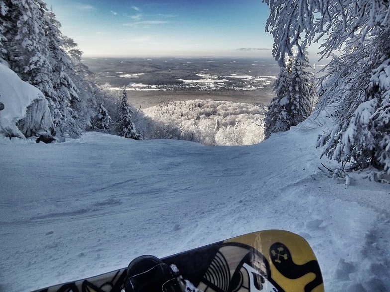
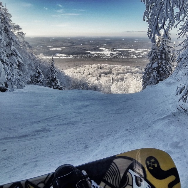
Go pro and carve into:
Avalanche information: Avalanche Canada
Latest snow reports near Mont Sutton:
| Top snow depth: | — |
|---|---|
| Bottom snow depth: | — |
| Fresh snowfall depth: | — |
| Last snowfall: | 7 May 2026 |
| Snow Alerts | Create Alert |
0.0 | Bluebird Powder days Fresh snow, mostly sunny, light wind. |
|---|---|
0.0 | Powder days Fresh snow, limited sun, any wind. |
0.0 | Bluebird days Average snow, mostly sunny, light wind. |
The above table gives the weather forecast for Mont Sutton at the specific elevation of 740 m. Our sophisticated weather models allow us to provide snow forecasts for the top, middle and bottom ski stations of Mont Sutton. To access the weather forecasts for the other elevations, use the tab navigation above the table. For a wider view of the weather, check out the Weather Map of Canada.
Click here to read further information on freezing levels and how we forecast our temperatures.
Overall 3.8 Based on 17 votes and 4 reviews
Lundi 2 janvier 2017 - Wow! Domaine skiable 100%?ouvertincluant les3 superbes pistes du Sud . Bonne base de début de saison consolidé avec lus de 55 cm de nouvelle neige en une semaine, combiné avec du très bon travail de damsge. Et en plus le soleil était au RDV avec des températures clémentes . Perfect ski day.
Bernard Mailhot from Canada writes:
Lundi 2 janvier 2017 - Wow! Domaine skiable 100%?ouvertincluant les3 superbes pistes du Sud .
Bonne base de début de saison consolidé avec lus de 55 cm de nouvelle neige en une semaine, combiné avec du très bon travail de damsge.
Et en plus le soleil était au RDV avec des températures clémentes .
Perfect ski day.


 Nearest