


Global Weekly Snow Roundup #314
Weekly Global Snow News, updated 14 May 2026: Fresh snowfall in Argentina, Australia and Lesotho signals winter’s approach, while Japan maintains the world’s deepest snowpack.

Next 3 days weather summary:Light rain (total 6.0mm), mostly falling on Thu night. Very mild (max 17°C on Sat afternoon, min 8°C on Thu night). Winds increasing (calm on Thu afternoon, fresh winds from the WSW by Sat night). | Days 4-6 weather summary:Light rain (total 4.0mm), mostly falling on Mon morning. Warm (max 25°C on Tue afternoon, min 8°C on Sun night). Winds increasing (calm on Sun night, fresh winds from the WSW by Tue night). | ||||||||||||||||
Thu 14 | Friday 15 | Saturday 16 | Sunday 17 | Monday 18 | Tuesday 19 | ||||||||||||
PM | night | AM | PM | night | AM | PM | night | AM | PM | night | AM | PM | night | AM | PM | night | |
cloudy | light rain | cloudy | rain shwrs | rain shwrs | clear | cloudy | rain shwrs | clear | clear | some clouds | light rain | cloudy | some clouds | some clouds | some clouds | rain shwrs | |
km/h | |||||||||||||||||
Snow map | 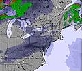 | 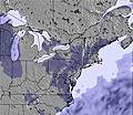 |  |  |  |  | |||||||||||
— | — | — | — | — | — | — | — | — | — | — | — | — | — | — | — | — | |
— | 2 | — | 2 | 1 | — | — | 1 | — | — | — | 1 | — | — | — | — | 3 | |
max °C | 9 | 9 | 13 | 16 | 13 | 15 | 17 | 13 | 13 | 17 | 14 | 10 | 16 | 18 | 23 | 25 | 23 |
min °C | 9 | 8 | 10 | 16 | 8 | 10 | 17 | 13 | 12 | 16 | 8 | 10 | 16 | 14 | 20 | 25 | 15 |
9 | 6 | 8 | 16 | 6 | 8 | 16 | 10 | 10 | 15 | 8 | 9 | 16 | 14 | 20 | 25 | 13 | |
90 | 92 | 73 | 66 | 93 | 57 | 71 | 86 | 55 | 43 | 55 | 73 | 78 | 88 | 67 | 72 | 93 | |
1950 | 2300 | 2250 | 2750 | 2750 | 3300 | 3100 | 3100 | 3150 | 3100 | 3550 | 3950 | 4350 | 4150 | 4000 | 4250 | 4100 | |
— | — | 5:24 | — | — | 5:24 | — | — | 5:22 | — | — | 5:22 | — | — | 5:20 | — | — | |
— | 8:20 | — | — | 8:21 | — | — | 8:22 | — | — | 8:22 | — | — | 8:23 | — | — | 8:25 | |
Latest snow reports near Mont Saint Sauveur:
| Top snow depth: | 25 cm |
|---|---|
| Bottom snow depth: | — |
| Fresh snowfall depth: | — |
| Last snowfall: | 5 Apr 2026 |
| Snow Alerts | Create Alert |
0.0 | Bluebird Powder days Fresh snow, mostly sunny, light wind. |
|---|---|
0.1 | Powder days Fresh snow, limited sun, any wind. |
0.0 | Bluebird days Average snow, mostly sunny, light wind. |

The above table gives the weather forecast for Mont Saint Sauveur at the specific elevation of 310 m. Our sophisticated weather models allow us to provide snow forecasts for the top, middle and bottom ski stations of Mont Saint Sauveur. To access the weather forecasts for the other elevations, use the tab navigation above the table. For a wider view of the weather, check out the Weather Map of Canada.
Click here to read further information on freezing levels and how we forecast our temperatures.
Overall 3.6 Based on 10 votes and 3 reviews
Saint SAUVEUR des Monts est la PERLE des LAURENTIDES. Au Printemps, tout est en feuilles & fleurs, en été les biches et chevreuil sont en liberté devant vos yeux, l'Autome l'Erable rougit et s'effeuille. Et l'Hiver, la neige & le ski Alpin ou de fond est partout pratiqué. Ne manquez pas la Rue Principale (très animée l'été) et l'hiver une multitude de boutiques colorées vous acceuillent dans leur interieur chaud et achalandé. Un Français des montagnes de Haute SAVOIE . BRAVO Saint SAUVEUR.
Paul MONATERI from France writes:
Saint SAUVEUR des Monts est la PERLE des LAURENTIDES.
Au Printemps, tout est en feuilles & fleurs, en été les biches et chevreuil sont en liberté devant vos yeux, l'Autome l'Erable rougit et s'effeuille. Et l'Hiver, la neige & le ski Alpin ou de fond est partout pratiqué. Ne manquez pas la Rue Principale (très animée l'été) et l'hiver une multitude de boutiques colorées vous acceuillent dans leur interieur chaud et achalandé.
Un Français des montagnes de Haute SAVOIE .
BRAVO Saint SAUVEUR.
Read 2 more reviews of Mont Saint Sauveur or submit your own


 Nearest