

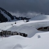
Portillo Re-Opens To Guests Arriving By Helicopter
Chile’s famous Portillo ski resort is reported to have re-opened to guests arriving by helicopter after being cut off by road for more than two weeks by over 6m/20 feet of snowfall.

Next 3 days weather summary:Heavy rain (total 23.0mm), heaviest during Wed night. Warm (max 24°C on Mon afternoon, min 16°C on Wed morning). Wind will be generally light. | Days 4-6 weather summary:Heavy rain (total 36.0mm), heaviest during Thu night. Very mild (max 19°C on Thu afternoon, min 11°C on Fri morning). Wind will be generally light. | ||||||||||||||||
Mon 3 | Tuesday 4 | Wednesday 5 | Thursday 6 | Friday 7 | Saturday 8 | ||||||||||||
PM | night | AM | PM | night | AM | PM | night | AM | PM | night | AM | PM | night | AM | PM | night | |
t-storm risk | rain shwrs | clear | some clouds | rain shwrs | rain shwrs | t-storm risk | t-storm risk | t-storm risk | t-storm risk | heavy rain | mod. rain | t-storm risk | rain shwrs | clear | t-storm risk | rain shwrs | |
km/h | |||||||||||||||||
Snow map |  |  |  |  |  | 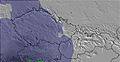 | |||||||||||
— | — | — | — | — | — | — | — | — | — | — | — | — | — | — | — | — | |
mm | 1 | 1 | — | — | 2 | 1 | 3 | 13 | 2 | 8 | 14 | 7 | 3 | 1 | — | 2 | 1 |
max °C | 24 | 20 | 21 | 23 | 22 | 18 | 20 | 19 | 18 | 19 | 15 | 11 | 13 | 13 | 14 | 16 | 15 |
min °C | 20 | 19 | 20 | 22 | 17 | 16 | 20 | 16 | 17 | 18 | 12 | 11 | 13 | 13 | 12 | 16 | 14 |
chill °C | 20 | 19 | 20 | 22 | 17 | 16 | 20 | 16 | 17 | 18 | 10 | 11 | 13 | 13 | 12 | 16 | 14 |
Humid % | 49 | 45 | 47 | 47 | 55 | 71 | 65 | 83 | 70 | 66 | 90 | 97 | 88 | 84 | 77 | 71 | 70 |
Freeze m | 4500 | 4500 | 4500 | 4550 | 4550 | 4500 | 4550 | 4500 | 4350 | 4350 | 4000 | 3800 | 4050 | 4050 | 3950 | 4050 | 4100 |
— | — | 5:48 | — | — | 5:50 | — | — | 5:52 | — | — | 5:52 | — | — | 5:54 | — | — | |
— | 8:40 | — | — | 8:39 | — | — | 8:37 | — | — | 8:37 | — | — | 8:35 | — | — | 8:34 | |
Go pro and carve into:
Avalanche information: European Avalanche Warning Services (EAWS)
Latest snow reports near Lofer:
| Top snow depth: | 0 cm |
|---|---|
| Bottom snow depth: | 0 cm |
| Fresh snowfall depth: | — |
| Last snowfall: | 16 May 2026 |
| Snow Alerts | Create Alert |
0.0 | Bluebird Powder days Fresh snow, mostly sunny, light wind. |
|---|---|
0.0 | Powder days Fresh snow, limited sun, any wind. |
0.0 | Bluebird days Average snow, mostly sunny, light wind. |
The above table gives the weather forecast for Lofer at the specific elevation of 1670 m. Our sophisticated weather models allow us to provide snow forecasts for the top, middle and bottom ski stations of Lofer. To access the weather forecasts for the other elevations, use the tab navigation above the table. For a wider view of the weather, check out the Weather Map of Austria.
Click here to read further information on freezing levels and how we forecast our temperatures.
Overall 3.6 Based on 14 votes and 5 reviews
We love Lofer. Great family resort, not too many queues and missed it for the last couple of years :-( . Excellent for young kids to learn, as we started our 4,5 and 8 yr old a good few years back, and they were well catered for. Can't wait to return in 5 weeks time and excited about spending new year on the slopes. Such great locals and always made to feel welcome wherever you go - our favourite place to ski ... PS - don't share this with too many people, as it will just become another hectic resort.
Francis Family from United Kingdom writes:
We love Lofer. Great family resort, not too many queues and missed it for the last couple of years :-( . Excellent for young kids to learn, as we started our 4,5 and 8 yr old a good few years back, and they were well catered for.
Can't wait to return in 5 weeks time and excited about spending new year on the slopes.
Such great locals and always made to feel welcome wherever you go - our favourite place to ski ...
PS - don't share this with too many people, as it will just become another hectic resort.


 Nearest