
North America Weekly Snow Roundup #321
Weekly Snow News for North America, updated 2 July 2026: Beartooth Basin summer ski area ends 2026 season with fresh snow falling and Banff's Sunshine celebrates Canada Day on the slopes.

Next 3 days weather summary:Light rain (total 9.0mm), mostly falling on Fri afternoon. Very mild (max 19°C on Thu afternoon, min 11°C on Fri night). Wind will be generally light. | Days 4-6 weather summary:Heavy rain (total 20.0mm), heaviest during Sun night. Warm (max 23°C on Tue afternoon, min 12°C on Sun night). Wind will be generally light. | |||||||||||||||||
Thursday 2 | Friday 3 | Saturday 4 | Sunday 5 | Monday 6 | Tuesday 7 | |||||||||||||
AM | PM | night | AM | PM | night | AM | PM | night | AM | PM | night | AM | PM | night | AM | PM | night | |
rain shwrs | some clouds | some clouds | rain shwrs | rain shwrs | rain shwrs | clear | clear | clear | some clouds | cloudy | mod. rain | light rain | t-storm risk | rain shwrs | some clouds | some clouds | cloudy | |
km/h | ||||||||||||||||||
Snow map |  |  |  | 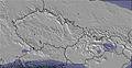 | 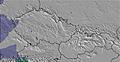 | 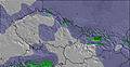 | ||||||||||||
— | — | — | — | — | — | — | — | — | — | — | — | — | — | — | — | — | — | |
mm | 1 | — | — | 2 | 4 | 2 | — | — | — | — | — | 7 | 4 | 5 | 4 | — | — | — |
max °C | 16 | 19 | 17 | 13 | 14 | 14 | 15 | 18 | 16 | 17 | 20 | 18 | 14 | 16 | 17 | 21 | 23 | 19 |
min °C | 13 | 18 | 16 | 13 | 13 | 11 | 13 | 17 | 13 | 15 | 19 | 12 | 12 | 14 | 15 | 18 | 21 | 18 |
chill °C | 13 | 18 | 16 | 12 | 12 | 11 | 13 | 17 | 13 | 15 | 19 | 11 | 11 | 14 | 15 | 18 | 21 | 18 |
Humid % | 59 | 45 | 59 | 93 | 84 | 72 | 47 | 41 | 62 | 52 | 44 | 93 | 80 | 76 | 62 | 36 | 42 | 45 |
Freeze m | 3300 | 3500 | 3300 | 3400 | 3450 | 3300 | 3200 | 3150 | 3200 | 3200 | 3450 | 3350 | 3200 | 3500 | 3500 | 3650 | 3800 | 3750 |
5:15 | — | — | 5:16 | — | — | 5:16 | — | — | 5:16 | — | — | 5:18 | — | — | 5:18 | — | — | |
— | — | 9:09 | — | — | 9:08 | — | — | 9:08 | — | — | 9:08 | — | — | 9:07 | — | — | 9:07 | |
Go pro and carve into:
Avalanche information: European Avalanche Warning Services (EAWS)
Latest snow reports near Lofer:
| Top snow depth: | 0 cm |
|---|---|
| Bottom snow depth: | 0 cm |
| Fresh snowfall depth: | — |
| Last snowfall: | 16 May 2026 |
| Snow Alerts | Create Alert |
0.0 | Bluebird Powder days Fresh snow, mostly sunny, light wind. |
|---|---|
0.0 | Powder days Fresh snow, limited sun, any wind. |
0.0 | Bluebird days Average snow, mostly sunny, light wind. |
The above table gives the weather forecast for Lofer at the specific elevation of 1155 m. Our sophisticated weather models allow us to provide snow forecasts for the top, middle and bottom ski stations of Lofer. To access the weather forecasts for the other elevations, use the tab navigation above the table. For a wider view of the weather, check out the Weather Map of Austria.
Click here to read further information on freezing levels and how we forecast our temperatures.
Overall 3.6 Based on 14 votes and 5 reviews
Just got back from a great week's skiing in Lofer. Have to agree with previous posts, made for families. Only negative is our experience on the four man lift, arriving before the 4pm closing time, found the station closed! After protest we were allowed access ( 2 children included ), if this hadn't been the case a long hike up the mountain would have faced us. Thought this would have been a one off but the following day we arrived at 3:45 and the lads were cliosing up!! The lazy, uncaring attitude of the lift staff apart, an ideal resort for families ( just don't ski till the death!)
Ian unsworth from United Kingdom writes:
Just got back from a great week's skiing in Lofer. Have to agree with previous posts, made for families. Only negative is our experience on the four man lift, arriving before the 4pm closing time, found the station closed! After protest we were allowed access ( 2 children included ), if this hadn't been the case a long hike up the mountain would have faced us. Thought this would have been a one off but the following day we arrived at 3:45 and the lads were cliosing up!!
The lazy, uncaring attitude of the lift staff apart, an ideal resort for families ( just don't ski till the death!)


 Nearest