

Portillo Storm Snowfall Total Passes 5m / 17 Feet
A snow storm that has now continued for nine days has taken Chilean ski resort Portillo to a snowfall total of 5.2 metres (17 feet) so far, with more snow forecast.

Next 3 days weather summary:Some drizzle, heaviest during Wed night. Warm (max 28°C on Thu afternoon, min 15°C on Tue morning). Wind will be generally light. | Days 4-6 weather summary:Heavy rain (total 22.0mm), heaviest during Sat night. Warm (max 27°C on Fri afternoon, min 18°C on Fri night). Wind will be generally light. | |||||||||||||||||
Tuesday 28 | Wednesday 29 | Thursday 30 | Friday 31 | Saturday 1 | Sunday 2 | |||||||||||||
AM | PM | night | AM | PM | night | AM | PM | night | AM | PM | night | AM | PM | night | AM | PM | night | |
clear | clear | clear | clear | clear | rain shwrs | clear | clear | some clouds | clear | some clouds | rain shwrs | clear | t-storm risk | rain shwrs | clear | rain shwrs | rain shwrs | |
km/h | ||||||||||||||||||
Snow map |  |  |  |  |  |  | ||||||||||||
— | — | — | — | — | — | — | — | — | — | — | — | — | — | — | — | — | — | |
mm | — | — | — | — | — | 1 | — | — | — | — | — | 4 | — | 1 | 13 | — | 1 | 3 |
max °C | 17 | 22 | 20 | 23 | 25 | 23 | 26 | 28 | 27 | 25 | 27 | 23 | 25 | 26 | 20 | 24 | 27 | 23 |
min °C | 15 | 21 | 19 | 21 | 25 | 22 | 24 | 28 | 23 | 24 | 26 | 18 | 22 | 22 | 18 | 22 | 24 | 21 |
chill °C | 15 | 21 | 19 | 21 | 25 | 22 | 24 | 28 | 23 | 24 | 26 | 18 | 22 | 22 | 18 | 22 | 24 | 21 |
Humid % | 68 | 50 | 67 | 48 | 46 | 45 | 28 | 21 | 37 | 33 | 39 | 60 | 42 | 63 | 68 | 45 | 48 | 43 |
Freeze m | 4350 | 4600 | 4500 | 4300 | 4400 | 4300 | 4350 | 4600 | 4550 | 4600 | 4500 | 4450 | 4550 | 4400 | 4450 | 4500 | 4550 | 4600 |
5:45 | — | — | 5:46 | — | — | 5:47 | — | — | 5:48 | — | — | 5:50 | — | — | 5:50 | — | — | |
— | — | 8:53 | — | — | 8:52 | — | — | 8:52 | — | — | 8:50 | — | — | 8:49 | — | — | 8:46 | |
Go pro and carve into:
Avalanche information: European Avalanche Warning Services (EAWS)
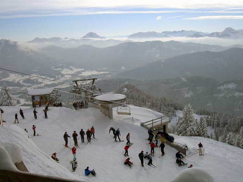
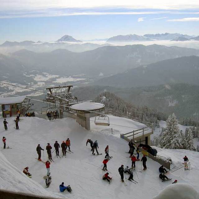
Latest snow reports near Lenggries:
| Top snow depth: | 0 cm |
|---|---|
| Bottom snow depth: | 0 cm |
| Fresh snowfall depth: | — |
| Last snowfall: | 16 May 2026 |
| Snow Alerts | Create Alert |
0.0 | Bluebird Powder days Fresh snow, mostly sunny, light wind. |
|---|---|
0.0 | Powder days Fresh snow, limited sun, any wind. |
0.0 | Bluebird days Average snow, mostly sunny, light wind. |
The above table gives the weather forecast for Lenggries at the specific elevation of 1200 m. Our sophisticated weather models allow us to provide snow forecasts for the top, middle and bottom ski stations of Lenggries. To access the weather forecasts for the other elevations, use the tab navigation above the table. For a wider view of the weather, check out the Weather Map of Germany.
Click here to read further information on freezing levels and how we forecast our temperatures.
Overall 4.2 Based on 11 votes and 2 reviews
I was a military brat that had the privalidge to grow up and spend 17 years in the Bad Toelz/ Lenggries area. My last 5 years in Germany I lived in Lenggries and can tell you it was an awesome experience. The locals are great and welcoming. I also know many of the bar/restaurant owners personally in town and, more importantly, on the ski slopes. I haven't been to very many resorts/towns in Germany. Austria, Italy or the USA that still have that hometown feeling and are not yet commercialized as if skiing into a McDonalds on the slopes. Lenggries is a very traditional town and yet only 1 hour by train from Munich, which makes it a very popular destination for people in that region. Sure there are larger and more popular resorts to ski in the area, but you can't beat that Bavarian Gemuetlichkeit in Lenggries and the lift ticket prices compared to Garmisch or some of the other larger resorts. I have skied many resorts in southern Europe and am always drawn back to Lenggries every year for that typical Bavarian charm.
GLENN JENSEN from United States writes:
I was a military brat that had the privalidge to grow up and spend 17 years in the Bad Toelz/ Lenggries area. My last 5 years in Germany I lived in Lenggries and can tell you it was an awesome experience. The locals are great and welcoming. I also know many of the bar/restaurant owners personally in town and, more importantly, on the ski slopes. I haven't been to very many resorts/towns in Germany. Austria, Italy or the USA that still have that hometown feeling and are not yet commercialized as if skiing into a McDonalds on the slopes. Lenggries is a very traditional town and yet only 1 hour by train from Munich, which makes it a very popular destination for people in that region. Sure there are larger and more popular resorts to ski in the area, but you can't beat that Bavarian Gemuetlichkeit in Lenggries and the lift ticket prices compared to Garmisch or some of the other larger resorts. I have skied many resorts in southern Europe and am always drawn back to Lenggries every year for that typical Bavarian charm.


 Nearest