

Global Weekly Snow Roundup #320
Weekly Snow News for the world, updated 25 June 2026: Chile and New Zealand's seasons proper set to begin, Tignes and Sunshine reopen for summer skiing. weekend as Riksgransen ends its 2026 season.

Next 3 days weather summary:Heavy rain (total 31.0mm), heaviest during Sun night. Warm (max 21°C on Sat afternoon, min 14°C on Mon morning). Wind will be generally light. | Days 4-6 weather summary:Heavy rain (total 40.0mm), heaviest during Tue night. Very mild (max 17°C on Tue afternoon, min 10°C on Wed night). Wind will be generally light. | ||||||||||||||||
Fri 26 | Saturday 27 | Sunday 28 | Monday 29 | Tuesday 30 | Wednesday 1 | ||||||||||||
PM | night | AM | PM | night | AM | PM | night | AM | PM | night | AM | PM | night | AM | PM | night | |
clear | clear | clear | t-storm risk | rain shwrs | clear | t-storm risk | rain shwrs | t-storm risk | mod. rain | mod. rain | some clouds | t-storm risk | rain shwrs | rain shwrs | t-storm risk | rain shwrs | |
km/h | |||||||||||||||||
Snow map |  |  |  |  |  |  | |||||||||||
— | — | — | — | — | — | — | — | — | — | — | — | — | — | — | — | — | |
mm | — | — | — | 1 | 6 | — | 2 | 18 | 4 | 8 | 7 | — | 4 | 11 | 1 | 5 | 4 |
max °C | 20 | 18 | 19 | 21 | 18 | 19 | 20 | 16 | 15 | 16 | 14 | 16 | 17 | 14 | 12 | 12 | 11 |
min °C | 19 | 17 | 18 | 20 | 17 | 18 | 19 | 15 | 14 | 15 | 14 | 15 | 16 | 12 | 12 | 12 | 10 |
chill °C | 19 | 17 | 18 | 20 | 17 | 18 | 19 | 15 | 14 | 15 | 14 | 15 | 16 | 11 | 11 | 11 | 8 |
Humid % | 49 | 59 | 55 | 61 | 52 | 55 | 62 | 58 | 78 | 76 | 72 | 64 | 71 | 71 | 79 | 85 | 73 |
Freeze m | 4500 | 4550 | 4550 | 4600 | 4650 | 4600 | 4550 | 4500 | 4300 | 4350 | 4400 | 4300 | 4400 | 4100 | 3900 | 3850 | 3500 |
— | — | 5:15 | — | — | 5:15 | — | — | 5:16 | — | — | 5:16 | — | — | 5:16 | — | — | |
— | 9:10 | — | — | 9:10 | — | — | 9:10 | — | — | 9:10 | — | — | 9:10 | — | — | 9:10 | |
Go pro and carve into:
Avalanche information: European Avalanche Warning Services (EAWS)
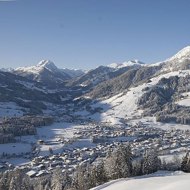
Latest snow reports near Kitzbühel:
| Top snow depth: | — |
|---|---|
| Bottom snow depth: | — |
| Fresh snowfall depth: | — |
| Last snowfall: | 16 May 2026 |
| Snow Alerts | Create Alert |
0.0 | Bluebird Powder days Fresh snow, mostly sunny, light wind. |
|---|---|
0.0 | Powder days Fresh snow, limited sun, any wind. |
0.0 | Bluebird days Average snow, mostly sunny, light wind. |
The above table gives the weather forecast for Kitzbühel at the specific elevation of 2000 m. Our sophisticated weather models allow us to provide snow forecasts for the top, middle and bottom ski stations of Kitzbühel. To access the weather forecasts for the other elevations, use the tab navigation above the table. For a wider view of the weather, check out the Weather Map of Austria.
Click here to read further information on freezing levels and how we forecast our temperatures.
Resort name is also written as Kitzbuhel.
Overall 4.3 Based on 21 votes and 26 reviews
Big mountain with plenty of runs for any level of rider. When I was here in late February 2019, there hadn't been any fresh snow for at least a week, and the diurnal freeze-thaw cycles made skiing off-piste very rough. Piste skiing became very crowded, although lift lines remained fairly short because of the high speed 8 and 6-pack chairs. Kitzbuhel is a beer desert! North Americans used to a selection of craft beers in bars will go into shock! Restaurant food is excellent, and prices are about 2/3 to half of what you would pay at US ski areas. Lift tickets are 1/3 the price of western us resorts, which made this trip to Kitz less expensive than going to Colorado, California, or other major Western US resorts. Austrian people have been very friendly, warm, and helpful.
Bruce G from United States writes:
Big mountain with plenty of runs for any level of rider. When I was here in late February 2019, there hadn't been any fresh snow for at least a week, and the diurnal freeze-thaw cycles made skiing off-piste very rough. Piste skiing became very crowded, although lift lines remained fairly short because of the high speed 8 and 6-pack chairs.
Kitzbuhel is a beer desert! North Americans used to a selection of craft beers in bars will go into shock! Restaurant food is excellent, and prices are about 2/3 to half of what you would pay at US ski areas. Lift tickets are 1/3 the price of western us resorts, which made this trip to Kitz less expensive than going to Colorado, California, or other major Western US resorts. Austrian people have been very friendly, warm, and helpful.


 Nearest