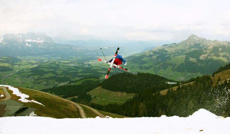


Banff Sunshine Village Opening for Summer Skiing
Banff Sunshine Village has confirmed it will reopen for a fortnight of summer skiing, from this weekend. The only ski area in Canada to be open into July.

Next 3 days weather summary:Light rain (total 6.0mm), mostly falling on Sat night. Warm (max 28°C on Sat afternoon, min 15°C on Sat night). Wind will be generally light. | Days 4-6 weather summary:Light rain (total 9.0mm), mostly falling on Tue night. Warm (max 28°C on Thu afternoon, min 15°C on Tue night). Wind will be generally light. | ||||||||||||||||
Sat 20 | Sunday 21 | Monday 22 | Tuesday 23 | Wednesday 24 | Thursday 25 | ||||||||||||
PM | night | AM | PM | night | AM | PM | night | AM | PM | night | AM | PM | night | AM | PM | night | |
rain shwrs | rain shwrs | clear | clear | clear | clear | clear | rain shwrs | clear | some clouds | rain shwrs | clear | t-storm risk | rain shwrs | clear | clear | rain shwrs | |
km/h | |||||||||||||||||
Snow map |  |  |  |  |  |  | |||||||||||
— | — | — | — | — | — | — | — | — | — | — | — | — | — | — | — | — | |
mm | 1 | 3 | — | — | — | — | — | 2 | — | — | 6 | — | 1 | 1 | — | — | 1 |
max °C | 28 | 18 | 26 | 28 | 23 | 26 | 28 | 22 | 25 | 27 | 19 | 24 | 27 | 22 | 25 | 28 | 23 |
min °C | 26 | 15 | 20 | 28 | 17 | 21 | 27 | 15 | 20 | 26 | 15 | 19 | 25 | 16 | 20 | 27 | 17 |
chill °C | 26 | 15 | 20 | 28 | 17 | 21 | 27 | 15 | 20 | 26 | 15 | 19 | 25 | 16 | 20 | 27 | 17 |
Humid % | 46 | 68 | 39 | 33 | 56 | 49 | 40 | 77 | 54 | 47 | 80 | 62 | 53 | 80 | 58 | 50 | 78 |
Freeze m | 4150 | 4200 | 4100 | 4200 | 4150 | 4100 | 4200 | 4200 | 4100 | 4200 | 4150 | 4150 | 4250 | 4350 | 4450 | 4550 | 4550 |
— | — | 5:13 | — | — | 5:13 | — | — | 5:13 | — | — | 5:13 | — | — | 5:13 | — | — | |
— | 9:10 | — | — | 9:10 | — | — | 9:10 | — | — | 9:10 | — | — | 9:10 | — | — | 9:10 | |
Go pro and carve into:
Avalanche information: European Avalanche Warning Services (EAWS)
Latest snow reports near Kirchberg:
| Top snow depth: | 0 cm |
|---|---|
| Bottom snow depth: | 0 cm |
| Fresh snowfall depth: | — |
| Last snowfall: | 16 May 2026 |
| Snow Alerts | Create Alert |
0.0 | Bluebird Powder days Fresh snow, mostly sunny, light wind. |
|---|---|
0.0 | Powder days Fresh snow, limited sun, any wind. |
0.0 | Bluebird days Average snow, mostly sunny, light wind. |
The above table gives the weather forecast for Kirchberg at the specific elevation of 860 m. Our sophisticated weather models allow us to provide snow forecasts for the top, middle and bottom ski stations of Kirchberg. To access the weather forecasts for the other elevations, use the tab navigation above the table. For a wider view of the weather, check out the Weather Map of Austria.
Click here to read further information on freezing levels and how we forecast our temperatures.
Overall 3.9 Based on 18 votes and 1 review
Kirchberg is a very pleasant and friendly village in the heart of the Austrian Tirol. Situated just 10km from the fashionable (and more expensive) resort of Kitzbuhel, this small village is a delight in both winter and summer. Accommodation can be found at all price levels from luxury to basic. Try 3* Hotel Bechlwirt, a very nice family run hotel with an excellent restaurant right in the centre of the village or, if on a lower budget, the extremely friendly Pension Schweigerhof and Haus Margaret just 10 mins walk from the centre. Finding a place to eat in Kirchberg is no problem with nay fine restaurants including Pizzerias and Cafes. The Kupfer Stub'n offers local and international culinary delights (booking always advisable) or for the best Pizza outside Italy visit Pizza Nabucco where a warm welcome is always received. There are many more resaurants worth a mention but it will take me too long. Free ski buses run every 15mins, from stops throughout the village, to the cable gondola at Klausen which is just 5mins outside Kirchberg. The lift takes you up to the Fleckalm at 1840m from where you can experience the impressive sequence of lifts covering 165km of piste in the Kitzbuheler Alpen including the famous Hahnenkamm. For a relaxing holiday in most beautiful surroundings, Summer or Winter, Kirchberg is the place to be. Enjoy.
Peter Allen from United Kingdom writes:
Kirchberg is a very pleasant and friendly village in the heart of the Austrian Tirol. Situated just 10km from the fashionable (and more expensive) resort of Kitzbuhel, this small village is a delight in both winter and summer. Accommodation can be found at all price levels from luxury to basic. Try 3* Hotel Bechlwirt, a very nice family run hotel with an excellent restaurant right in the centre of the village or, if on a lower budget, the extremely friendly Pension Schweigerhof and Haus Margaret just 10 mins walk from the centre. Finding a place to eat in Kirchberg is no problem with nay fine restaurants including Pizzerias and Cafes. The Kupfer Stub'n offers local and international culinary delights (booking always advisable) or for the best Pizza outside Italy visit Pizza Nabucco where a warm welcome is always received. There are many more resaurants worth a mention but it will take me too long.
Free ski buses run every 15mins, from stops throughout the village, to the cable gondola at Klausen which is just 5mins outside Kirchberg. The lift takes you up to the Fleckalm at 1840m from where you can experience the impressive sequence of lifts covering 165km of piste in the Kitzbuheler Alpen including the famous Hahnenkamm.
For a relaxing holiday in most beautiful surroundings, Summer or Winter, Kirchberg is the place to be. Enjoy.


 Nearest