
Is Kandel (Kandellifte) snowsure?
The snowiest week in Kandel (Kandellifte) is week 2 of January. There are typically 2.5 snowy days during this week with 19 cm of snowfall. Check out the Kandel (Kandellifte) Snow History graphs below. Select any week of the year to see the typical Ski Conditions, Snowfall Amount and Temperature based on nowcast weather data over the last 11 years.Average monthly snow in Kandel (Kandellifte)
| Month | Snow amount (week) | Snow days (week) |
|---|---|---|
| December | 9 cm | 2.0 days |
| January | 13 cm | 2.4 days |
| February | 9 cm | 1.7 days |
| March | 7 cm | 1.7 days |
| April | 6 cm | 1.2 days |
Average Snow and Weather Conditions in Kandel (Kandellifte) during November (week 2):
The average snowfall forecast during week 2 of November for Kandel (Kandellifte) is 2 cm. There are typically 1.0 snowy days during this week. Kandel (Kandellifte) prevailing weather and snow conditions during the second week of November at the middle elevation of the ski area at 1090m, based on historical averages over the last 7 years: At this time of year the mean freezing level (2313m) is a long way above the middle elevation of Kandel (Kandellifte). Expect just one day with snowfall per week in Kandel (Kandellifte) in the middle of November and on average there is one wet day during this week every year too. Forecast model average snowfall for the week is 2cm. Temperatures generally above freezing both day and night in Kandel (Kandellifte) during week two of November with average maximum temperature 6.7°C and minimum temperature 5.7°C at the middle elevation. On average, a couple of days per week will have some sunshine. Mostly light winds (average 18km/h) are unlikely to affect ski lifts but you can expect the mean wind to reach 30km/h one day per week. Sunny, calm and below freezing perfect weather days that follow fresh snow (bluebird powder days) are not expected this week but fresh snow days that do not have ideal conditions are more typical, on average one year in 7..
Snow History: Compare Resorts
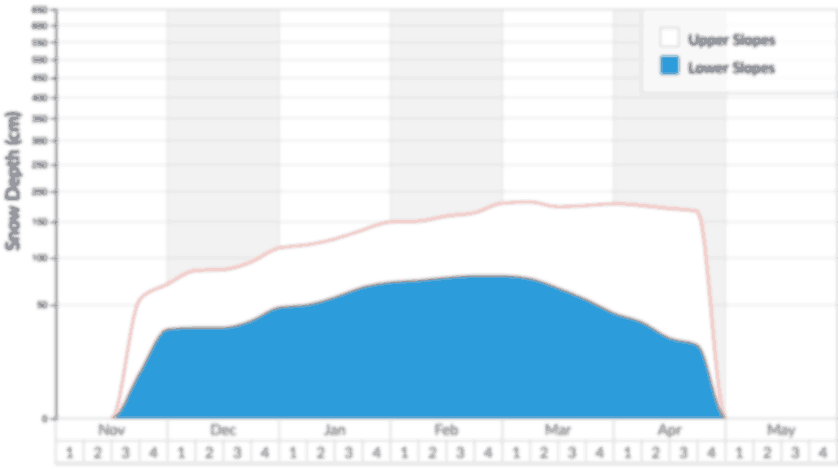
Kandel (Kandellifte) Snow Depths
Recorded snow depths for the upper and lower slopes in Kandel (Kandellifte) and (2018 – 2026).

The most cherished days on the mountain in Kandel (Kandellifte) are Bluebird Powder days when it is mostly sunny with light winds following very recent snowfall. Poorer weather conditions may prevail on Powder days when the visibility can be limited but the snow is significantly deep and fresh for keen powder-hounds. Bluebird days can suit many skiers that aren’t necessarily hunting powder but want to enjoy the snowy mountains in sunnier conditions and light winds.

The snowiest weeks of the year in Kandel (Kandellifte) are shown but also bear in mind the number of days that it typically snows each week if you want regular fresh tracks. The risk of a rainy day is shown but be sure to switch between elevations to see if lower lifts are rain affected or higher lifts remain snowy despite any rain further down the mountain.

The highest and lowest temperatures averaged for each week of the year in Kandel (Kandellifte) are shown. Check out the risk of freze-thaw conditions prevailing at different elevations for any given week. We also show the extremes of temperature (blue/red dots) that reveal the chance of unusually warm or cold conditions.
 Nearest