

Portillo Re-Opens To Guests Arriving By Helicopter
Chile’s famous Portillo ski resort is reported to have re-opened to guests arriving by helicopter after being cut off by road for more than two weeks by over 6m/20 feet of snowfall.

Next 3 days weather summary:Heavy rain (total 21.0mm), heaviest during Wed night. Very mild (max 17°C on Mon afternoon, min 11°C on Wed night). Wind will be generally light. | Days 4-6 weather summary:Heavy rain (total 39.0mm), heaviest during Thu night. Very mild (max 15°C on Thu afternoon, min 9°C on Thu night). Wind will be generally light. | |||||||||||||||||
Monday 3 | Tuesday 4 | Wednesday 5 | Thursday 6 | Friday 7 | Saturday 8 | |||||||||||||
AM | PM | night | AM | PM | night | AM | PM | night | AM | PM | night | AM | PM | night | AM | PM | night | |
clear | t-storm risk | some clouds | clear | t-storm risk | rain shwrs | t-storm risk | t-storm risk | rain shwrs | t-storm risk | t-storm risk | heavy rain | cloudy | t-storm risk | rain shwrs | clear | t-storm risk | rain shwrs | |
km/h | ||||||||||||||||||
Snow map |  |  |  |  |  |  | ||||||||||||
— | — | — | — | — | — | — | — | — | — | — | — | — | — | — | — | — | — | |
mm | — | 2 | — | — | 3 | 2 | 1 | 3 | 10 | 3 | 7 | 20 | — | 3 | 2 | — | 3 | 1 |
max °C | 16 | 17 | 15 | 16 | 17 | 15 | 14 | 16 | 13 | 14 | 15 | 12 | 10 | 11 | 10 | 11 | 12 | 11 |
min °C | 13 | 16 | 12 | 14 | 15 | 12 | 12 | 15 | 11 | 12 | 14 | 9 | 9 | 11 | 9 | 9 | 12 | 10 |
chill °C | 13 | 16 | 11 | 14 | 15 | 12 | 12 | 15 | 11 | 12 | 14 | 8 | 9 | 11 | 9 | 9 | 12 | 9 |
Humid % | 47 | 56 | 70 | 53 | 65 | 72 | 67 | 70 | 82 | 67 | 79 | 91 | 77 | 89 | 90 | 79 | 80 | 62 |
Freeze m | 4500 | 4550 | 4450 | 4500 | 4650 | 4500 | 4400 | 4500 | 4400 | 4350 | 4400 | 3950 | 4000 | 4000 | 4000 | 4000 | 4100 | 4250 |
5:56 | — | — | 5:58 | — | — | 5:58 | — | — | 6:01 | — | — | 6:01 | — | — | 6:03 | — | — | |
— | — | 8:46 | — | — | 8:45 | — | — | 8:45 | — | — | 8:43 | — | — | 8:42 | — | — | 8:39 | |
Go pro and carve into:
Avalanche information: European Avalanche Warning Services (EAWS)
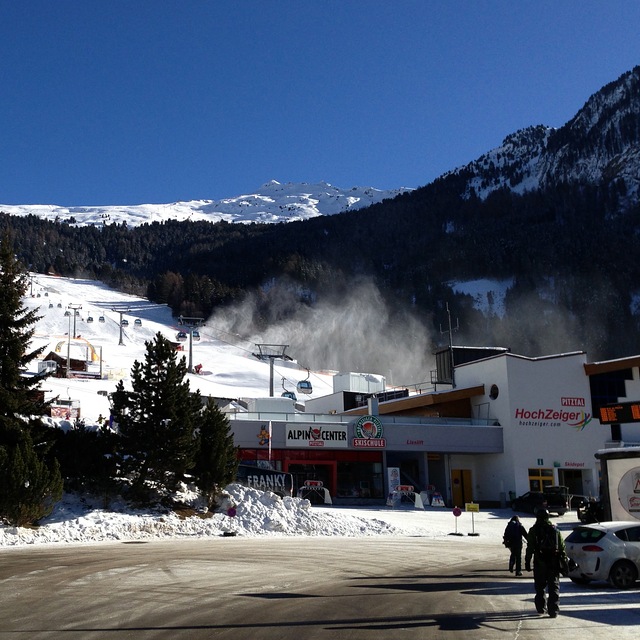
Latest snow reports near Hochzeiger:
| Top snow depth: | — |
|---|---|
| Bottom snow depth: | — |
| Fresh snowfall depth: | — |
| Last snowfall: | 10 Jun 2026 |
| Snow Alerts | Create Alert |
0.0 | Bluebird Powder days Fresh snow, mostly sunny, light wind. |
|---|---|
0.0 | Powder days Fresh snow, limited sun, any wind. |
0.0 | Bluebird days Average snow, mostly sunny, light wind. |
The above table gives the weather forecast for Hochzeiger at the specific elevation of 2370 m. Our sophisticated weather models allow us to provide snow forecasts for the top, middle and bottom ski stations of Hochzeiger. To access the weather forecasts for the other elevations, use the tab navigation above the table. For a wider view of the weather, check out the Weather Map of Austria.
Click here to read further information on freezing levels and how we forecast our temperatures.
Overall 3.3 Based on 3 votes and 1 review
Hochzeiger resort is a great place to find that has not been over run by Brits. I have been going to this area since my army days of serious cross country skiing in 1967, when I was fit. My German friend introduced me to Hochzeiger 10 years ago and we normally stay in Wenns 6kms away. The hotel Schirgantblick is fantastic and will pick you up from the bars at the bottom of the lifts if you miss the last bus. The costs at this resort are a fraction of the large ones like St Anton. Last year, Feb 2008, we didn't come across any other Brits in the area and the hotel found us almost a novelty. Can't fault Hochzeiger, except my wife isn't keen on the free bus from Wenns (20mins) and 20 hairpin bends. Recommend it but fly to Innsbruck as the journey is only 55mins and the hotel will collect you free of charge.
mike Bourne from United Kingdom writes:
Hochzeiger resort is a great place to find that has not been over run by Brits. I have been going to this area since my army days of serious cross country skiing in 1967, when I was fit. My German friend introduced me to Hochzeiger 10 years ago and we normally stay in Wenns 6kms away. The hotel Schirgantblick is fantastic and will pick you up from the bars at the bottom of the lifts if you miss the last bus. The costs at this resort are a fraction of the large ones like St Anton. Last year, Feb 2008, we didn't come across any other Brits in the area and the hotel found us almost a novelty. Can't fault Hochzeiger, except my wife isn't keen on the free bus from Wenns (20mins) and 20 hairpin bends. Recommend it but fly to Innsbruck as the journey is only 55mins and the hotel will collect you free of charge.


 Nearest