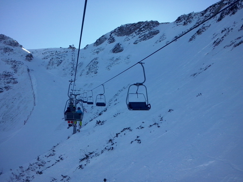


Portillo Re-Opens To Guests Arriving By Helicopter
Chile’s famous Portillo ski resort is reported to have re-opened to guests arriving by helicopter after being cut off by road for more than two weeks by over 6m/20 feet of snowfall.

Next 3 days weather summary:Light rain (total 4.0mm), mostly falling on Wed night. Warm (max 25°C on Tue afternoon, min 17°C on Wed night). Wind will be generally light. | Days 4-6 weather summary:Heavy rain (total 20.0mm), heaviest during Thu afternoon. Warm (max 22°C on Thu afternoon, min 11°C on Fri morning). Wind will be generally light. | |||||||||||||||||
Monday 3 | Tuesday 4 | Wednesday 5 | Thursday 6 | Friday 7 | Saturday 8 | |||||||||||||
AM | PM | night | AM | PM | night | AM | PM | night | AM | PM | night | AM | PM | night | AM | PM | night | |
clear | clear | clear | clear | clear | clear | clear | clear | t-storm risk | t-storm risk | mod. rain | mod. rain | light rain | light rain | some clouds | clear | some clouds | clear | |
km/h | ||||||||||||||||||
Snow map |  |  |  |  |  |  | ||||||||||||
— | — | — | — | — | — | — | — | — | — | — | — | — | — | — | — | — | — | |
mm | — | — | — | — | — | — | — | — | 4 | 2 | 6 | 9 | 1 | 2 | — | — | — | — |
max °C | 21 | 23 | 23 | 22 | 25 | 24 | 19 | 22 | 21 | 18 | 22 | 19 | 11 | 13 | 13 | 14 | 17 | 16 |
min °C | 20 | 23 | 22 | 21 | 24 | 20 | 19 | 22 | 17 | 18 | 18 | 12 | 11 | 12 | 12 | 12 | 16 | 15 |
chill °C | 20 | 23 | 22 | 21 | 24 | 20 | 19 | 22 | 17 | 18 | 18 | 10 | 10 | 12 | 12 | 12 | 16 | 15 |
Humid % | 40 | 37 | 39 | 43 | 34 | 38 | 68 | 54 | 63 | 75 | 70 | 95 | 94 | 86 | 77 | 62 | 57 | 58 |
Freeze m | 4450 | 4450 | 4600 | 4600 | 4550 | 4600 | 4450 | 4550 | 4500 | 4450 | 4450 | 4300 | 4000 | 4150 | 3950 | 3950 | 3900 | 3850 |
5:39 | — | — | 5:39 | — | — | 5:41 | — | — | 5:43 | — | — | 5:43 | — | — | 5:45 | — | — | |
— | — | 8:32 | — | — | 8:30 | — | — | 8:30 | — | — | 8:28 | — | — | 8:27 | — | — | 8:24 | |
Go pro and carve into:
Avalanche information: European Avalanche Warning Services (EAWS)
Latest snow reports near Hochkar-Göstling:
| Top snow depth: | 0 cm |
|---|---|
| Bottom snow depth: | 0 cm |
| Fresh snowfall depth: | — |
| Last snowfall: | 10 Jun 2026 |
| Snow Alerts | Create Alert |
0.0 | Bluebird Powder days Fresh snow, mostly sunny, light wind. |
|---|---|
0.0 | Powder days Fresh snow, limited sun, any wind. |
0.0 | Bluebird days Average snow, mostly sunny, light wind. |
The above table gives the weather forecast for Hochkar-Göstling at the specific elevation of 1593 m. Our sophisticated weather models allow us to provide snow forecasts for the top, middle and bottom ski stations of Hochkar-Göstling. To access the weather forecasts for the other elevations, use the tab navigation above the table. For a wider view of the weather, check out the Weather Map of Austria.
Click here to read further information on freezing levels and how we forecast our temperatures.
Resort name is also written as Hochkar-Gostling.
Overall 3.7 Based on 12 votes and 1 review
I skied here on their last open weekend in April of 2008. With about 10 cm of fresh snow and about 20 other skiers on the mountain, it was an amazing day. Unfortunately the low clouds limited my ability to explore, but I was in untracked powder all day, often in the low trees. Most of the on-mountain facilities were closed for the season, but I only needed the one chalet that was open for a Kasekrainer and Almdudler. As I pulled out of the parking lot at the end of the day, the clouds lifted to show more of the mountain that I hadn't had time to reach. This isn't a destination ski resort, but it's close enough to Vienna to provide, for me at least, some excellent unexpected thrills.
BRich from United States writes:
I skied here on their last open weekend in April of 2008. With about 10 cm of fresh snow and about 20 other skiers on the mountain, it was an amazing day. Unfortunately the low clouds limited my ability to explore, but I was in untracked powder all day, often in the low trees. Most of the on-mountain facilities were closed for the season, but I only needed the one chalet that was open for a Kasekrainer and Almdudler. As I pulled out of the parking lot at the end of the day, the clouds lifted to show more of the mountain that I hadn't had time to reach. This isn't a destination ski resort, but it's close enough to Vienna to provide, for me at least, some excellent unexpected thrills.


 Nearest