


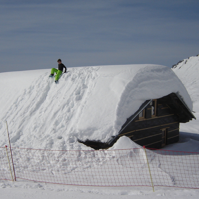
Portillo Storm Snowfall Total Passes 5m / 17 Feet
A snow storm that has now continued for nine days has taken Chilean ski resort Portillo to a snowfall total of 5.2 metres (17 feet) so far, with more snow forecast.

Next 3 days weather summary:Moderate rain (total 12.0mm), heaviest on Fri night. Warm (max 27°C on Fri afternoon, min 15°C on Fri night). Wind will be generally light. | Days 4-6 weather summary:Moderate rain (total 15.0mm), heaviest on Mon night. Warm (max 26°C on Sun afternoon, min 15°C on Mon night). Wind will be generally light. | |||||||||||||||||
Wednesday 29 | Thursday 30 | Friday 31 | Saturday 1 | Sunday 2 | Monday 3 | |||||||||||||
AM | PM | night | AM | PM | night | AM | PM | night | AM | PM | night | AM | PM | night | AM | PM | night | |
clear | clear | clear | clear | some clouds | some clouds | clear | some clouds | rain shwrs | rain shwrs | some clouds | rain shwrs | clear | clear | some clouds | clear | t-storm risk | rain shwrs | |
km/h | ||||||||||||||||||
Snow map |  |  |  |  |  |  | ||||||||||||
— | — | — | — | — | — | — | — | — | — | — | — | — | — | — | — | — | — | |
mm | — | — | — | — | — | — | — | — | 12 | 1 | — | 1 | — | — | — | — | 1 | 12 |
max °C | 21 | 24 | 23 | 24 | 26 | 25 | 24 | 27 | 18 | 21 | 24 | 22 | 22 | 26 | 24 | 22 | 25 | 17 |
min °C | 18 | 23 | 20 | 21 | 25 | 21 | 21 | 25 | 15 | 19 | 23 | 18 | 19 | 25 | 18 | 19 | 23 | 15 |
chill °C | 18 | 23 | 20 | 21 | 25 | 21 | 21 | 25 | 14 | 19 | 23 | 18 | 19 | 25 | 18 | 19 | 23 | 15 |
Humid % | 52 | 29 | 30 | 23 | 21 | 40 | 33 | 31 | 58 | 47 | 37 | 58 | 39 | 30 | 56 | 42 | 48 | 63 |
Freeze m | 4450 | 4600 | 4650 | 4600 | 4700 | 4750 | 4700 | 4700 | 4650 | 4450 | 4650 | 4650 | 4600 | 4800 | 4650 | 4650 | 4550 | 4550 |
6:11 | — | — | 6:13 | — | — | 6:13 | — | — | 6:16 | — | — | 6:16 | — | — | 6:18 | — | — | |
— | — | 9:07 | — | — | 9:05 | — | — | 9:04 | — | — | 9:02 | — | — | 9:00 | — | — | 9:00 | |
Go pro and carve into:
Avalanche information: European Avalanche Warning Services (EAWS)
Latest snow reports near Hauteluce Val Joly:
No information received. Another glorious day. from La Giettaz en Aravis
| Top snow depth: | — |
|---|---|
| Bottom snow depth: | — |
| Fresh snowfall depth: | — |
| Last snowfall: | 15 May 2026 |
| Snow Alerts | Create Alert |
0.0 | Bluebird Powder days Fresh snow, mostly sunny, light wind. |
|---|---|
0.0 | Powder days Fresh snow, limited sun, any wind. |
0.0 | Bluebird days Average snow, mostly sunny, light wind. |
The above table gives the weather forecast for Hauteluce Val Joly at the specific elevation of 1650 m. Our sophisticated weather models allow us to provide snow forecasts for the top, middle and bottom ski stations of Hauteluce Val Joly. To access the weather forecasts for the other elevations, use the tab navigation above the table. For a wider view of the weather, check out the Weather Map of France.
Click here to read further information on freezing levels and how we forecast our temperatures.
Overall 3.0 Based on 2 votes and 1 review
Hauteluce is a small resort in itself, but it is linked into the Espace Diamant at one end of the commune, and into Les Contamines Montjoie at the other end. Unfortunately, there's no common lift pass, but either area is plenty big enough for everyone except the "mileage" skiers of this world (and frankly I don't see the fun in any of that). Hauteluce is also very close to Albertville.
James Smith from United Kingdom writes:
Hauteluce is a small resort in itself, but it is linked into the Espace Diamant at one end of the commune, and into Les Contamines Montjoie at the other end. Unfortunately, there's no common lift pass, but either area is plenty big enough for everyone except the "mileage" skiers of this world (and frankly I don't see the fun in any of that). Hauteluce is also very close to Albertville.


 Nearest