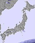
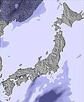
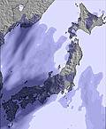
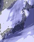
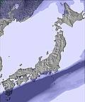
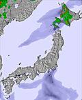
The above table gives the weather forecast for Grandeko Ski Resort at the specific elevation of 1300 m. Our sophisticated weather models allow us to provide snow forecasts for the top, middle and bottom ski stations of Grandeko Ski Resort. To access the weather forecasts for the other elevations, use the tab navigation above the table. For a wider view of the weather, check out the Weather Map of Japan.
Click here to read further information on freezing levels and how we forecast our temperatures.
It could be a much better resort if its management had any idea of what it was doing!
The grooming manager should be sacked. The amount of useless grooming where no one skis, particularly at the bottom of the mountain, is atrocious. They groom to the top of the black runs, seducing the beginners onto the run with no option to get out and then leave the steep part un-groomed. Then they groom the last twenty metres. The widest runs are groomed right to the edges, again an unnecessary expense, with untracked grooming late in the day.
Every lift is too low. Suit a 3 year old but no one older. At the top of each lift there is no off-ramp but a hill climb to get off. Then it is an uphill hike to get to the runs.
They are anal about off-piste skiing with useless restrictions. Long fences everywhere near the top of runs trying to stop you getting to the best skiing. Under the lift lines, where the best wide open powder lives, is supposedly banned. Why they do not allow it is beyond common sense when the chairs are way above skiers heads and the only decent vertical is there.
The whole place is too flat for anyone above intermediate but could be made very good with a different company attitude plus a decent mountain and grooming manager.
Nekoma and Alts Bandai are much better, even though both could be a lot better with some better lift exits and more relaxed attitudes to off-piste skiing.
If it snows here the skiing is great. Without consistent powder all 3 are boring.
Free Snow-Forecast.com weather widget for your website
Embed the Grandeko Ski Resort weather widget on your site for free. It provides a weekly snapshot of snow and rain conditions across all elevations. Follow the two quick steps to grab your custom code and paste it into your site. Choose between metric or imperial units. Click here to get the code.


 Nearest