

Banff Sunshine Village Opening for Summer Skiing
Banff Sunshine Village has confirmed it will reopen for a fortnight of summer skiing, from this weekend. The only ski area in Canada to be open into July.

Next 3 days weather summary:Moderate rain (total 10.0mm), heaviest on Sat night. Very mild (max 16°C on Fri afternoon, min 6°C on Sat night). Winds decreasing (fresh winds from the SW on Fri night, calm by Sun night). | Days 4-6 weather summary:Some drizzle, heaviest during Tue night. Very mild (max 18°C on Wed afternoon, min 9°C on Mon morning). Winds increasing (calm on Tue night, strong winds from the WSW by Wed afternoon). | |||||||||||||||||
Friday 19 | Saturday 20 | Sunday 21 | Monday 22 | Tuesday 23 | Wednesday 24 | |||||||||||||
AM | PM | night | AM | PM | night | AM | PM | night | AM | PM | night | AM | PM | night | AM | PM | night | |
clear | clear | some clouds | some clouds | t-storm risk | rain shwrs | rain shwrs | some clouds | clear | clear | clear | clear | clear | clear | rain shwrs | clear | clear | some clouds | |
km/h | ||||||||||||||||||
Snow map |  |  | 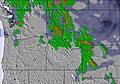 | 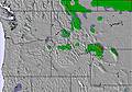 | 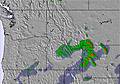 | 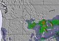 | ||||||||||||
— | — | — | — | — | — | — | — | — | — | — | — | — | — | — | — | — | — | |
mm | — | — | — | — | 2 | 7 | 1 | — | — | — | — | — | — | — | 1 | — | — | — |
max °C | 14 | 16 | 16 | 13 | 12 | 10 | 9 | 13 | 12 | 11 | 13 | 12 | 13 | 16 | 16 | 15 | 18 | 16 |
min °C | 11 | 16 | 13 | 11 | 11 | 6 | 7 | 11 | 8 | 9 | 12 | 11 | 11 | 15 | 14 | 14 | 17 | 14 |
chill °C | 9 | 14 | 11 | 8 | 8 | 4 | 5 | 8 | 6 | 8 | 10 | 10 | 9 | 14 | 13 | 12 | 15 | 13 |
Humid % | 18 | 18 | 24 | 40 | 63 | 74 | 73 | 50 | 35 | 45 | 39 | 36 | 33 | 18 | 25 | 31 | 24 | 26 |
Freeze m | 4350 | 4750 | 4850 | 4450 | 4250 | 4050 | 3900 | 4300 | 4400 | 4100 | 4400 | 4550 | 4450 | 4750 | 4900 | 4650 | 4900 | 4800 |
5:41 | — | — | 5:41 | — | — | 5:41 | — | — | 5:41 | — | — | 5:41 | — | — | 5:41 | — | — | |
— | — | 9:07 | — | — | 9:08 | — | — | 9:08 | — | — | 9:08 | — | — | 9:08 | — | — | 9:08 | |
Go pro and carve into:
Avalanche information: National Avalanche Center
Latest snow reports near Grand Targhee:
| Top snow depth: | 0 cm |
|---|---|
| Bottom snow depth: | 0 cm |
| Fresh snowfall depth: | — |
| Last snowfall: | 10 Jun 2026 |
| Snow Alerts | Create Alert |
0.0 | Bluebird Powder days Fresh snow, mostly sunny, light wind. |
|---|---|
0.2 | Powder days Fresh snow, limited sun, any wind. |
0.1 | Bluebird days Average snow, mostly sunny, light wind. |
The above table gives the weather forecast for Grand Targhee at the specific elevation of 2772 m. Our sophisticated weather models allow us to provide snow forecasts for the top, middle and bottom ski stations of Grand Targhee. To access the weather forecasts for the other elevations, use the tab navigation above the table. For a wider view of the weather, check out the Weather Map of United States.
Click here to read further information on freezing levels and how we forecast our temperatures.
Overall 3.5 Based on 17 votes and 5 reviews
I went to Targhee and bought 3 full-priced lift tickets. I learned after the fact that my local season pass entitled me to Mountain Collective benefits. The Activities Center was unwilling to provide a refund. Interestingly, the two people I spoke to both had very different reasons for why they wouldn't refund me, neither of which were honest or honourable. I was stupid for not reading the fine print, they were greedy and unethical. Despicable Customer Service. Targhee used to be a great mountain when its prices were competitive and they offered Snowcat skiing. Now lift tickets cost almost as much as Jackson Hole ($135 vs. $200), as does the food and lodging. Jackson Hole is an infinitely better mountain, and Jackson or Teton Village, WY are infinitely better places to stay than Victor or Driggs, ID. Don't waste your time and money at Targhee, they certainly don't deserve it. [note from the editor: names of individuals are not included in reviews.]
Greg Robinson from United States writes:
I went to Targhee and bought 3 full-priced lift tickets. I learned after the fact that my local season pass entitled me to Mountain Collective benefits. The Activities Center was unwilling to provide a refund. Interestingly, the two people I spoke to both had very different reasons for why they wouldn't refund me, neither of which were honest or honourable.
I was stupid for not reading the fine print, they were greedy and unethical.
Despicable Customer Service.
Targhee used to be a great mountain when its prices were competitive and they offered Snowcat skiing. Now lift tickets cost almost as much as Jackson Hole ($135 vs. $200), as does the food and lodging. Jackson Hole is an infinitely better mountain, and Jackson or Teton Village, WY are infinitely better places to stay than Victor or Driggs, ID.
Don't waste your time and money at Targhee, they certainly don't deserve it.
[note from the editor: names of individuals are not included in reviews.]


 Nearest