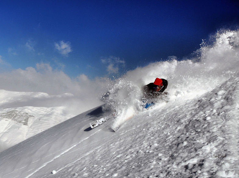


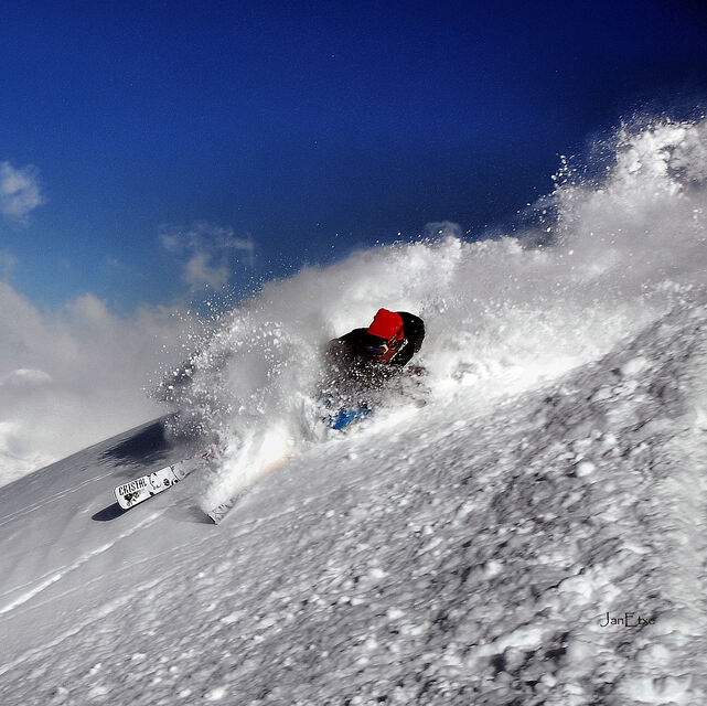
Portillo Storm Snowfall Total Passes 5m / 17 Feet
A snow storm that has now continued for nine days has taken Chilean ski resort Portillo to a snowfall total of 5.2 metres (17 feet) so far, with more snow forecast.

Next 3 days weather summary:Some drizzle, heaviest during Fri morning. Warm (max 22°C on Thu afternoon, min 15°C on Fri night). Wind will be generally light. | Days 4-6 weather summary:Moderate rain (total 10.0mm), heaviest on Mon night. Warm (max 21°C on Sun afternoon, min 14°C on Mon night). Wind will be generally light. | |||||||||||||||||
Thursday 30 | Friday 31 | Saturday 1 | Sunday 2 | Monday 3 | Tuesday 4 | |||||||||||||
AM | PM | night | AM | PM | night | AM | PM | night | AM | PM | night | AM | PM | night | AM | PM | night | |
some clouds | some clouds | some clouds | rain shwrs | clear | clear | clear | some clouds | clear | clear | clear | clear | some clouds | t-storm risk | rain shwrs | some clouds | some clouds | clear | |
km/h | ||||||||||||||||||
Snow map |  |  |  |  |  |  | ||||||||||||
— | — | — | — | — | — | — | — | — | — | — | — | — | — | — | — | — | — | |
mm | — | — | — | 1 | — | — | — | — | — | — | — | — | — | 3 | 7 | — | — | — |
max °C | 21 | 22 | 21 | 18 | 19 | 16 | 17 | 19 | 18 | 20 | 21 | 20 | 16 | 16 | 15 | 16 | 17 | 17 |
min °C | 18 | 21 | 17 | 16 | 18 | 15 | 15 | 18 | 17 | 18 | 20 | 16 | 15 | 16 | 14 | 15 | 17 | 14 |
chill °C | 18 | 21 | 16 | 15 | 18 | 15 | 14 | 18 | 17 | 18 | 20 | 16 | 15 | 16 | 14 | 15 | 17 | 14 |
Humid % | 34 | 41 | 49 | 49 | 53 | 60 | 57 | 55 | 52 | 43 | 42 | 50 | 55 | 68 | 64 | 60 | 65 | 72 |
Freeze m | 4750 | 4850 | 4850 | 4600 | 4700 | 4650 | 4650 | 4700 | 4800 | 4700 | 4750 | 4700 | 4500 | 4400 | 4500 | 4400 | 4450 | 4650 |
6:48 | — | — | 6:50 | — | — | 6:50 | — | — | 6:52 | — | — | 6:52 | — | — | 6:54 | — | — | |
— | — | 9:24 | — | — | 9:23 | — | — | 9:22 | — | — | 9:21 | — | — | 9:20 | — | — | 9:19 | |
Go pro and carve into:
Avalanche information: European Avalanche Warning Services (EAWS)
Latest snow reports near Gourette:
| Top snow depth: | 0 cm |
|---|---|
| Bottom snow depth: | 0 cm |
| Fresh snowfall depth: | — |
| Last snowfall: | 16 May 2026 |
| Snow Alerts | Create Alert |
0.0 | Bluebird Powder days Fresh snow, mostly sunny, light wind. |
|---|---|
0.0 | Powder days Fresh snow, limited sun, any wind. |
0.0 | Bluebird days Average snow, mostly sunny, light wind. |
The above table gives the weather forecast for Gourette at the specific elevation of 1900 m. Our sophisticated weather models allow us to provide snow forecasts for the top, middle and bottom ski stations of Gourette. To access the weather forecasts for the other elevations, use the tab navigation above the table. For a wider view of the weather, check out the Weather Map of France.
Click here to read further information on freezing levels and how we forecast our temperatures.
Overall 3.6 Based on 21 votes and 6 reviews
Excellente station avec plus de mètres de dénivelé,de 2450 à 1400 mètres d'altitude! Trés bonnes pistes bien préparées et toujours bien enneigées de novembre à fin avril grace à une exposition nord de l'ensemble du domaine.
ERIC BASTIE from France writes:
Excellente station avec plus de mètres de dénivelé,de 2450 à 1400 mètres d'altitude!
Trés bonnes pistes bien préparées et toujours bien enneigées de novembre à fin avril grace à une exposition nord de l'ensemble du domaine.


 Nearest