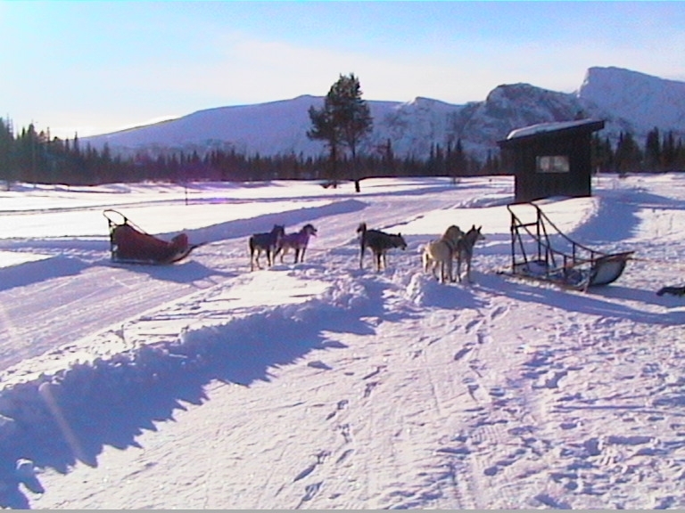


Portillo Re-Opens To Guests Arriving By Helicopter
Chile’s famous Portillo ski resort is reported to have re-opened to guests arriving by helicopter after being cut off by road for more than two weeks by over 6m/20 feet of snowfall.

Next 3 days weather summary:Heavy rain (total 32.0mm), heaviest during Wed night. Very mild (max 13°C on Tue afternoon, min 3°C on Mon morning). Wind will be generally light. | Days 4-6 weather summary:Moderate rain (total 15.0mm), heaviest on Thu morning. Very mild (max 11°C on Thu afternoon, min 5°C on Fri night). Winds increasing (calm on Fri morning, fresh winds from the SSW by Sat afternoon). | |||||||||||||||||
Monday 3 | Tuesday 4 | Wednesday 5 | Thursday 6 | Friday 7 | Saturday 8 | |||||||||||||
AM | PM | night | AM | PM | night | AM | PM | night | AM | PM | night | AM | PM | night | AM | PM | night | |
cloudy | clear | some clouds | some clouds | some clouds | mod. rain | light rain | light rain | heavy rain | light rain | light rain | rain shwrs | light rain | rain shwrs | some clouds | cloudy | light rain | rain shwrs | |
km/h | ||||||||||||||||||
Snow map | 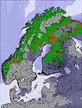 | 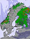 | 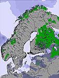 | 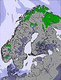 | 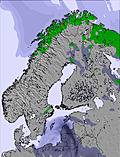 | 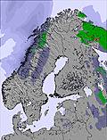 | ||||||||||||
— | — | — | — | — | — | — | — | — | — | — | — | — | — | — | — | — | — | |
mm | — | — | — | — | — | 7 | 1 | 5 | 19 | 3 | 3 | 3 | 1 | 2 | — | — | 2 | 1 |
max °C | 4 | 7 | 6 | 8 | 13 | 10 | 9 | 10 | 10 | 10 | 11 | 10 | 9 | 10 | 9 | 7 | 7 | 8 |
min °C | 3 | 6 | 4 | 5 | 11 | 8 | 8 | 10 | 9 | 9 | 10 | 8 | 8 | 10 | 5 | 5 | 7 | 5 |
chill °C | -1 | 3 | 2 | 5 | 10 | 8 | 8 | 9 | 8 | 7 | 8 | 7 | 7 | 9 | 3 | 2 | 2 | 2 |
Humid % | 91 | 63 | 74 | 60 | 45 | 100 | 98 | 98 | 99 | 78 | 84 | 81 | 76 | 59 | 75 | 76 | 91 | 81 |
Freeze m | 1800 | 2400 | 2300 | 2800 | 2700 | 3250 | 3150 | 3150 | 3000 | 2650 | 2700 | 2550 | 2450 | 2550 | 2300 | 2400 | 2400 | 2150 |
5:07 | — | — | 5:09 | — | — | 5:11 | — | — | 5:13 | — | — | 5:16 | — | — | 5:18 | — | — | |
— | — | 9:57 | — | — | 9:54 | — | — | 9:52 | — | — | 9:49 | — | — | 9:46 | — | — | 9:44 | |
Go pro and carve into:
Avalanche information: Varsom.no Avalanche Warnings
Latest snow reports near Geilo:
| Top snow depth: | 0 cm |
|---|---|
| Bottom snow depth: | 0 cm |
| Fresh snowfall depth: | — |
| Last snowfall: | 15 May 2026 |
| Snow Alerts | Create Alert |
0.0 | Bluebird Powder days Fresh snow, mostly sunny, light wind. |
|---|---|
0.0 | Powder days Fresh snow, limited sun, any wind. |
0.0 | Bluebird days Average snow, mostly sunny, light wind. |


The above table gives the weather forecast for Geilo at the specific elevation of 1175 m. Our sophisticated weather models allow us to provide snow forecasts for the top, middle and bottom ski stations of Geilo. To access the weather forecasts for the other elevations, use the tab navigation above the table. For a wider view of the weather, check out the Weather Map of Norway.
Click here to read further information on freezing levels and how we forecast our temperatures.
Overall 3.9 Based on 22 votes and 9 reviews
I have skied at Geilo many times with my family. I have been told that Geilo is the oldest downhill ski resort in the world and that Dr Holms is the oldest ski-in ski-out hotel. Fly to Oslo/Bergen and take the train (easy to book online in English); one of the top 10 train journeys in the world. The resort is a brilliant place to learn to ski. The instructors are multilingual and very good with children. The runs are not challenging for advanced skiers but the cold crisp snow creates a perfect environment to improve technique.
Edwin Harrell from United Kingdom writes:
I have skied at Geilo many times with my family. I have been told that Geilo is the oldest downhill ski resort in the world and that Dr Holms is the oldest ski-in ski-out hotel. Fly to Oslo/Bergen and take the train (easy to book online in English); one of the top 10 train journeys in the world. The resort is a brilliant place to learn to ski. The instructors are multilingual and very good with children. The runs are not challenging for advanced skiers but the cold crisp snow creates a perfect environment to improve technique.


 Nearest