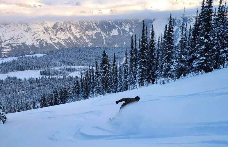


Portillo Re-Opens To Guests Arriving By Helicopter
Chile’s famous Portillo ski resort is reported to have re-opened to guests arriving by helicopter after being cut off by road for more than two weeks by over 6m/20 feet of snowfall.

Next 3 days weather summary:Light rain (total 4.0mm), mostly falling on Mon morning. Warm (max 21°C on Wed afternoon, min 5°C on Mon night). Wind will be generally light. | Days 4-6 weather summary:Moderate rain (total 16.0mm), heaviest on Sat night. Warm (max 23°C on Thu afternoon, min 8°C on Thu night). Wind will be generally light. | |||||||||||||||||
Monday 3 | Tuesday 4 | Wednesday 5 | Thursday 6 | Friday 7 | Saturday 8 | |||||||||||||
AM | PM | night | AM | PM | night | AM | PM | night | AM | PM | night | AM | PM | night | AM | PM | night | |
rain shwrs | light rain | rain shwrs | some clouds | some clouds | some clouds | some clouds | clear | clear | clear | clear | clear | some clouds | light rain | rain shwrs | rain shwrs | t-storm risk | mod. rain | |
km/h | ||||||||||||||||||
Snow map | 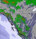 | 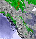 | 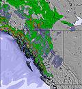 | 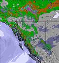 | 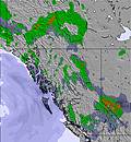 | 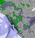 | ||||||||||||
— | — | — | — | — | — | — | — | — | — | — | — | — | — | — | — | — | — | |
mm | 1 | 2 | 1 | — | — | — | — | — | — | — | — | — | — | 1 | 1 | 1 | 5 | 8 |
max °C | 11 | 14 | 10 | 16 | 18 | 13 | 19 | 21 | 16 | 20 | 23 | 14 | 21 | 22 | 13 | 17 | 19 | 11 |
min °C | 6 | 13 | 5 | 11 | 18 | 8 | 14 | 21 | 9 | 14 | 23 | 8 | 14 | 17 | 8 | 12 | 15 | 8 |
chill °C | 6 | 13 | 5 | 11 | 18 | 8 | 14 | 21 | 9 | 14 | 23 | 8 | 14 | 17 | 8 | 12 | 15 | 8 |
Humid % | 80 | 41 | 65 | 52 | 28 | 43 | 45 | 27 | 52 | 56 | 28 | 84 | 57 | 32 | 91 | 80 | 46 | 90 |
Freeze m | 2650 | 3150 | 3300 | 3250 | 3850 | 4000 | 3850 | 4350 | 4400 | 4150 | 4450 | 4500 | 4400 | 4350 | 4150 | 3950 | 4100 | 4050 |
6:09 | — | — | 6:11 | — | — | 6:11 | — | — | 6:13 | — | — | 6:15 | — | — | 6:16 | — | — | |
— | — | 9:22 | — | — | 9:21 | — | — | 9:20 | — | — | 9:17 | — | — | 9:15 | — | — | 9:14 | |
Go pro and carve into:
Avalanche information: Avalanche Canada
Latest snow reports near Fortress Mountain:
| Top snow depth: | — |
|---|---|
| Bottom snow depth: | — |
| Fresh snowfall depth: | — |
| Last snowfall: | 12 Jun 2026 |
| Snow Alerts | Create Alert |
0.0 | Bluebird Powder days Fresh snow, mostly sunny, light wind. |
|---|---|
0.0 | Powder days Fresh snow, limited sun, any wind. |
0.0 | Bluebird days Average snow, mostly sunny, light wind. |
The above table gives the weather forecast for Fortress Mountain at the specific elevation of 1800 m. Our sophisticated weather models allow us to provide snow forecasts for the top, middle and bottom ski stations of Fortress Mountain. To access the weather forecasts for the other elevations, use the tab navigation above the table. For a wider view of the weather, check out the Weather Map of Canada.
Click here to read further information on freezing levels and how we forecast our temperatures.
Overall 3.3 Based on 2 votes and 10 reviews
I remember skiing Fortress back in the late 80's and loved it. Hope it will open again - hope they reopen the old lodge too - was a great place to stay - totally old school skiing and lots of good fun.
Kathleen from Canada writes:
I remember skiing Fortress back in the late 80's and loved it. Hope it will open again - hope they reopen the old lodge too - was a great place to stay - totally old school skiing and lots of good fun.


 Nearest