
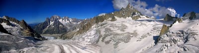
New Record High Temperatures in The Alps
Mont Blanc has been thawing at all levels with the freezing point rising several hundred metres above its summit for the first time ever in June and remaining so through the night.
By using Snow-Forecast, you agree to our Terms & Services.
Don't have an account? Join now
Alternatively, you can now use your Outside account to sign in to any brand in the Outside digital ecosystem, including Snow-Forecast, Surf-Forecast, and Mountain-Forecast.


Engelberg Weather (Next 3 days): The snow forecast for Engelberg is: Heavy rain (total 28.0mm), heaviest during Wed afternoon. Very mild (max 17°C on Wed afternoon, min 12°C on Thu night). Wind will be generally light.
Engelberg Weather (Days 4-6): Heavy rain (total 33.0mm), heaviest during Sun night. Very mild (max 16°C on Sun morning, min 5°C on Mon night). Wind will be generally light.
| Resort | Snow Depth | Temp. (°C) | Wind (km/h) | Weather | ||
|---|---|---|---|---|---|---|
| Top Lift: | 0.0 m | 8 | ||||
| Middle Lift: | 14 | |||||
| Bottom Lift: | 0.0 m | 17 |
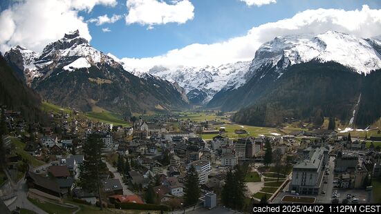
Latest snow reports near Engelberg:

Wednesday 2 | Thursday 3 | Friday 4 | Saturday 5 | Sunday 6 | Monday 7 | Tuesday 8 | |||||||||||||||
AM | PM | night | AM | PM | night | AM | PM | night | AM | PM | night | AM | PM | night | AM | PM | night | AM | PM | night | |
clear | risk thun- der | light rain | some clouds | risk thun- der | rain shwrs | risk thun- der | risk thun- der | rain shwrs | clear | risk thun- der | rain shwrs | clear | light rain | heavy rain | light rain | light rain | rain shwrs | some clouds | rain shwrs | rain shwrs | |
km/h | |||||||||||||||||||||
Snow map |  |  |  |  |  |  |  | ||||||||||||||
— | — | — | — | — | — | — | — | — | — | — | — | — | — | — | — | — | — | — | — | — | |
— | 5 | 4 | — | 7 | 7 | 2 | 2 | 1 | — | 3 | 4 | — | 4 | 16 | 2 | 2 | 2 | — | 2 | 1 | |
max°C | 16 | 17 | 14 | 14 | 14 | 13 | 12 | 13 | 13 | 14 | 15 | 14 | 16 | 15 | 8 | 6 | 7 | 6 | 6 | 8 | 7 |
min°C | 15 | 14 | 13 | 14 | 14 | 12 | 12 | 13 | 12 | 12 | 14 | 13 | 14 | 11 | 7 | 6 | 6 | 5 | 5 | 7 | 6 |
15 | 14 | 12 | 14 | 14 | 11 | 11 | 13 | 12 | 12 | 14 | 12 | 14 | 11 | 5 | 4 | 4 | 3 | 3 | 6 | 5 | |
53 | 74 | 56 | 66 | 76 | 69 | 74 | 74 | 65 | 68 | 74 | 61 | 48 | 86 | 94 | 95 | 87 | 75 | 69 | 74 | 68 | |
4250 | 4300 | 4200 | 4200 | 4200 | 4300 | 3950 | 4050 | 4200 | 4100 | 4200 | 4150 | 4100 | 3850 | 3350 | 3100 | 3100 | 3000 | 2800 | 3000 | 2950 | |
5:35 | — | — | 5:35 | — | — | 5:37 | — | — | 5:37 | — | — | 5:39 | — | — | 5:39 | — | — | 5:39 | — | — | |
— | — | 9:23 | — | — | 9:22 | — | — | 9:22 | — | — | 9:22 | — | — | 9:22 | — | — | 9:22 | — | — | 9:21 | |
Heavy rain (total 28.0mm), heaviest during Wed afternoon. Very mild (max 17°C on Wed afternoon, min 12°C on Thu night). Wind will be generally light.
Heavy rain (total 33.0mm), heaviest during Sun night. Very mild (max 16°C on Sun morning, min 5°C on Mon night). Wind will be generally light.
Latest snow reports near Engelberg:
| Top snow depth: | 0 cm |
|---|---|
| Bottom snow depth: | 0 cm |
| Fresh snowfall depth: | — |
| Last snowfall: | 24 May 2025 |
| Snow Alerts | Create Alert |
0.0 | Bluebird Powder days Fresh snow, mostly sunny, light wind. |
|---|---|
0.0 | Powder days Fresh snow, limited sun, any wind. |
0.0 | Bluebird days Average snow, mostly sunny, light wind. |


The above table gives the weather forecast for Engelberg at the specific elevation of 2085 m. Our sophisticated weather models allow us to provide snow forecasts for the top, middle and bottom ski stations of Engelberg. To access the weather forecasts for the other elevations, use the tab navigation above the table. For a wider view of the weather, check out the Weather Map of Switzerland.
Click here to read further information on freezing levels and how we forecast our temperatures.
Overall 3.8 Based on 22 votes and 21 reviews
Moved here from Chamonix, worse decision ever. Compared to Chamonix this area is busy and lacking in off-piste, ski touring and variety. I would not recommend any expert skiers coming here. This place is horrendous. Can’t wait to move out at the end of season.
Anna Nykvist from Switzerland writes:
Moved here from Chamonix, worse decision ever. Compared to Chamonix this area is busy and lacking in off-piste, ski touring and variety. I would not recommend any expert skiers coming here. This place is horrendous. Can’t wait to move out at the end of season.
The Engelberg skiing weather widget is available to embed on external websites free of charge. It provides a daily summary of our Engelberg snow forecast and current weather conditions. Simply go to the feed configuration page and follow the 3 simple steps to grab the custom html code snippet and paste it into your own site. You can choose the snow forecast elevation (summit, mid-mountain or bottom lift) and metric/imperial units for the snow forecast feed to suit your own website…. Click here to get the code.
View detailed snow forecast for Engelberg at:
snow-forecast.com


 Nearest