

Portillo Re-Opens To Guests Arriving By Helicopter
Chile’s famous Portillo ski resort is reported to have re-opened to guests arriving by helicopter after being cut off by road for more than two weeks by over 6m/20 feet of snowfall.

Next 3 days weather summary:Heavy rain (total 25.0mm), heaviest during Tue night. Very mild (max 12°C on Mon afternoon, min 8°C on Tue night). Wind will be generally light. | Days 4-6 weather summary:Moderate rain (total 14.0mm), heaviest on Thu afternoon. Mild temperatures (max 9°C on Thu morning, min 7°C on Thu afternoon). Wind will be generally light. | Days 7-9 weather summary:Light rain (total 6.0mm), mostly falling on Tue night. Very mild (max 12°C on Mon afternoon, min 8°C on Sun morning). Wind will be generally light. | Days 10-12 weather summary:Moderate rain (total 11.0mm), heaviest on Thu night. Freeze-thaw conditions (max 11°C on Wed afternoon, min 0°C on Fri night). Wind will be generally light. | Days 13-16 weather summary:Light rain (total 8.0mm), mostly falling on Tue afternoon. Freeze-thaw conditions (max 9°C on Mon afternoon, min 0°C on Sat night). Wind will be generally light. | |||||||||||||||||||||||||||||||||||||||||||
Monday 3 | Tuesday 4 | Wednesday 5 | Thursday 6 | Friday 7 | Saturday 8 | Sunday 9 | Monday 10 | Tuesday 11 | Wednesday 12 | Thursday 13 | Friday 14 | Saturday 15 | Sunday 16 | Monday 17 | Tue 18 | ||||||||||||||||||||||||||||||||
AM | PM | night | AM | PM | night | AM | PM | night | AM | PM | night | AM | PM | night | AM | PM | night | AM | PM | night | AM | PM | night | AM | PM | night | AM | PM | night | AM | PM | night | AM | PM | night | AM | PM | night | AM | PM | night | AM | PM | night | AM | PM | |
clear | some clouds | rain shwrs | clear | t-storm risk | rain shwrs | rain shwrs | t-storm risk | rain shwrs | clear | mod. rain | rain shwrs | clear | some clouds | some clouds | clear | rain shwrs | rain shwrs | clear | clear | clear | clear | clear | rain shwrs | some clouds | some clouds | rain shwrs | clear | clear | clear | clear | t-storm risk | rain shwrs | rain shwrs | t-storm risk | clear | clear | clear | snow shwrs | clear | clear | clear | some clouds | clear | rain shwrs | cloudy | light rain | |
km/h | |||||||||||||||||||||||||||||||||||||||||||||||
Snow map |  |  |  |  |  |  |  |  |  |  |  |  |  |  |  |  | |||||||||||||||||||||||||||||||
— | — | — | — | — | — | — | — | — | — | — | — | — | — | — | — | — | — | — | — | — | — | — | — | — | — | — | — | — | — | — | — | — | — | — | — | — | — | — | — | — | — | — | — | — | — | — | |
mm | — | — | 6 | — | 4 | 8 | 1 | 3 | 3 | — | 6 | 6 | — | — | — | — | 1 | 1 | — | — | — | — | — | 2 | — | — | 4 | — | — | — | — | 1 | 5 | 3 | 2 | — | — | — | — | — | — | — | — | — | 1 | — | 4 |
max °C | 11 | 12 | 10 | 10 | 11 | 9 | 9 | 9 | 9 | 9 | 9 | 7 | 8 | 8 | 8 | 8 | 8 | 9 | 8 | 10 | 10 | 10 | 12 | 12 | 11 | 12 | 11 | 10 | 11 | 10 | 9 | 10 | 8 | 5 | 4 | 2 | 2 | 1 | 4 | 6 | 6 | 8 | 8 | 9 | 9 | 8 | 6 |
min °C | 10 | 11 | 9 | 9 | 9 | 8 | 8 | 9 | 8 | 9 | 7 | 7 | 7 | 8 | 7 | 7 | 8 | 8 | 8 | 9 | 9 | 9 | 11 | 10 | 10 | 12 | 9 | 9 | 10 | 9 | 9 | 9 | 5 | 4 | 3 | 0 | 1 | 1 | 0 | 5 | 6 | 7 | 8 | 9 | 6 | 7 | 6 |
chill °C | 10 | 11 | 8 | 8 | 7 | 8 | 8 | 9 | 7 | 9 | 5 | 6 | 7 | 7 | 6 | 6 | 8 | 7 | 7 | 8 | 8 | 9 | 11 | 9 | 9 | 11 | 8 | 9 | 10 | 8 | 7 | 7 | 2 | 0 | -1 | -3 | -2 | -1 | -3 | 3 | 5 | 6 | 6 | 7 | 5 | 4 | 5 |
Humid % | 52 | 63 | 70 | 62 | 80 | 75 | 70 | 87 | 64 | 56 | 91 | 69 | 58 | 79 | 63 | 46 | 72 | 39 | 61 | 54 | 49 | 44 | 45 | 55 | 51 | 49 | 71 | 55 | 63 | 60 | 58 | 65 | 83 | 83 | 93 | 45 | 44 | 84 | 26 | 34 | 57 | 20 | 21 | 45 | 52 | 67 | 85 |
Freeze m | 4550 | 4650 | 4450 | 4450 | 4450 | 4400 | 4400 | 4400 | 4400 | 4350 | 4250 | 4200 | 4100 | 4150 | 4250 | 4200 | 4200 | 4350 | 4150 | 4350 | 4400 | 4400 | 4600 | 4500 | 4450 | 4650 | 4450 | 4450 | 4550 | 4400 | 4300 | 4400 | 4000 | 3700 | 3550 | 3250 | 3350 | 3200 | 3500 | 4000 | 3850 | 4250 | 4200 | 4350 | 4400 | 4150 | 4000 |
6:13 | — | — | 6:13 | — | — | 6:15 | — | — | 6:16 | — | — | 6:18 | — | — | 6:18 | — | — | 6:20 | — | — | 6:22 | — | — | 6:22 | — | — | 6:24 | — | — | 6:24 | — | — | 6:26 | — | — | 6:28 | — | — | 6:28 | — | — | 6:30 | — | — | 6:31 | — | |
— | — | 8:58 | — | — | 8:57 | — | — | 8:55 | — | — | 8:53 | — | — | 8:52 | — | — | 8:51 | — | — | 8:50 | — | — | 8:47 | — | — | 8:46 | — | — | 8:45 | — | — | 8:43 | — | — | 8:42 | — | — | 8:39 | — | — | 8:38 | — | — | 8:37 | — | 8:35 | |
Avalanche information: European Avalanche Warning Services (EAWS)
Latest snow reports near Crans Montana:
| Top snow depth: | 0 cm |
|---|---|
| Bottom snow depth: | 0 cm |
| Fresh snowfall depth: | — |
| Last snowfall: | 10 Jun 2026 |
| Snow Alerts | Create Alert |
0.0 | Bluebird Powder days Fresh snow, mostly sunny, light wind. |
|---|---|
0.2 | Powder days Fresh snow, limited sun, any wind. |
0.1 | Bluebird days Average snow, mostly sunny, light wind. |

The above table gives the weather forecast for Crans Montana at the specific elevation of 3000 m. Our sophisticated weather models allow us to provide snow forecasts for the top, middle and bottom ski stations of Crans Montana. To access the weather forecasts for the other elevations, use the tab navigation above the table. For a wider view of the weather, check out the Weather Map of Switzerland.
Click here to read further information on freezing levels and how we forecast our temperatures.
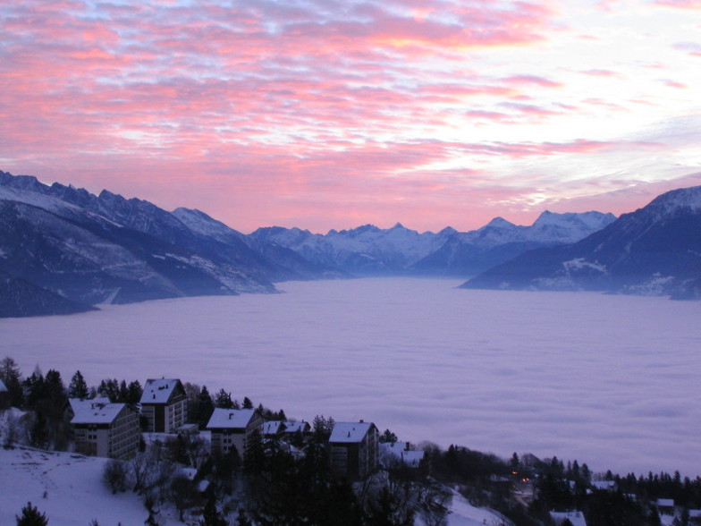
dave liddle from United Kingdom writes:
We have owned an apartment here for the past 6 years and been coming a few times every year since. My son learned to ski here and is now 12 and very proficient. The resort has everything; great runs, great restaurants and cool bars like Amadeus and Zero Dix. That said the apres-ski and night life is not like some of the Austrian resorts and is much more reserved. The views and a beer at Amadeus overlooking the valley is something to look forward to every year. We enjoy this resort and it is improving each year with new faster lifts and restaurants. There are also no queues like France and most of the other more popular resorts. It is a great place!


 Nearest