


Portillo Storm Snowfall Total Passes 5m / 17 Feet
A snow storm that has now continued for nine days has taken Chilean ski resort Portillo to a snowfall total of 5.2 metres (17 feet) so far, with more snow forecast.

Next 4 days weather summary:Moderate rain (total 11.0mm), heaviest on Thu afternoon. Very mild (max 17°C on Thu morning, min 14°C on Fri night). Wind will be generally light. | Days 5-7 weather summary:Mostly dry. Very mild (max 19°C on Mon morning, min 14°C on Sat night). Wind will be generally light. | |||||||||||||||
Thursday 30 | Friday 31 | Saturday 1 | Sunday 2 | Monday 3 | ||||||||||||
night | AM | PM | night | AM | PM | night | AM | PM | night | AM | PM | night | AM | PM | night | |
light rain | cloudy | light rain | light rain | light rain | rain shwrs | cloudy | cloudy | cloudy | clear | some clouds | some clouds | clear | some clouds | some clouds | some clouds | |
km/h | ||||||||||||||||
Snow map |  |  | 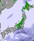 |  |  |  | ||||||||||
— | — | — | — | — | — | — | — | — | — | — | — | — | — | — | — | |
mm | 4 | — | 3 | 2 | 1 | 1 | — | — | — | — | — | — | — | — | — | — |
max °C | 16 | 17 | 17 | 16 | 16 | 17 | 15 | 16 | 16 | 15 | 18 | 18 | 16 | 19 | 19 | 17 |
min °C | 16 | 17 | 16 | 15 | 16 | 16 | 14 | 16 | 16 | 14 | 17 | 17 | 16 | 18 | 18 | 16 |
chill °C | 15 | 17 | 16 | 15 | 16 | 15 | 14 | 16 | 16 | 14 | 17 | 17 | 16 | 18 | 18 | 16 |
Humid % | 98 | 93 | 96 | 99 | 95 | 78 | 73 | 64 | 68 | 75 | 78 | 81 | 83 | 82 | 82 | 91 |
Freeze m | 4300 | 4350 | 4250 | 4150 | 4100 | 4200 | 4450 | 4550 | 4650 | 4800 | 4900 | 5000 | 5100 | 5050 | 5200 | 5300 |
— | 4:24 | — | — | 4:26 | — | — | 4:26 | — | — | 4:28 | — | — | 4:30 | — | — | |
— | — | 7:00 | — | — | 7:00 | — | — | 6:59 | — | — | 6:58 | — | — | 6:57 | — | |
Go pro and carve into:
Avalanche information: Japan Avalanche Network
Latest snow reports near Chisenupurri:
| Top snow depth: | — |
|---|---|
| Bottom snow depth: | — |
| Fresh snowfall depth: | — |
| Last snowfall: | 4 May 2026 |
| Snow Alerts | Create Alert |
0.0 | Bluebird Powder days Fresh snow, mostly sunny, light wind. |
|---|---|
0.0 | Powder days Fresh snow, limited sun, any wind. |
0.0 | Bluebird days Average snow, mostly sunny, light wind. |
The above table gives the weather forecast for Chisenupurri at the specific elevation of 827 m. Our sophisticated weather models allow us to provide snow forecasts for the top, middle and bottom ski stations of Chisenupurri. To access the weather forecasts for the other elevations, use the tab navigation above the table. For a wider view of the weather, check out the Weather Map of Japan.
Click here to read further information on freezing levels and how we forecast our temperatures.
Chisenupurri is pretty sweet for a single day of skiing, but there is, simply, not enough terrain for anything more. That said, it's a great spot, a little flat in places but there's always untracked powder. Make sure you don't go on a big powder day, as you won't be able to go downhill! We were knee to thigh deep and it was great.
Joe from Australia writes:
Chisenupurri is pretty sweet for a single day of skiing, but there is, simply, not enough terrain for anything more.
That said, it's a great spot, a little flat in places but there's always untracked powder. Make sure you don't go on a big powder day, as you won't be able to go downhill! We were knee to thigh deep and it was great.


 Nearest