
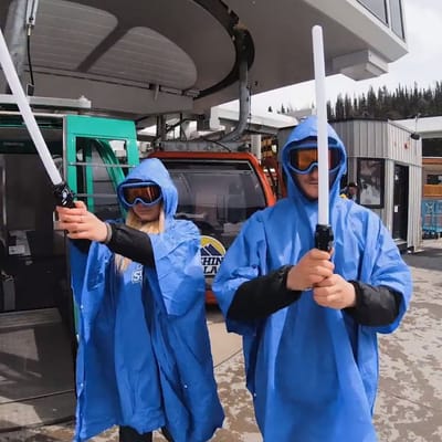
Ski Areas Ready for Star Wars Day
Several North American ski areas that are still open plan to celebrate the unofficial Star Wars Day tomorrow, May the Fourth (be with you).
Please sign in with your Snow-Forecast account details below.
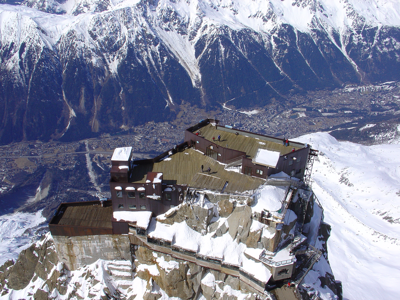


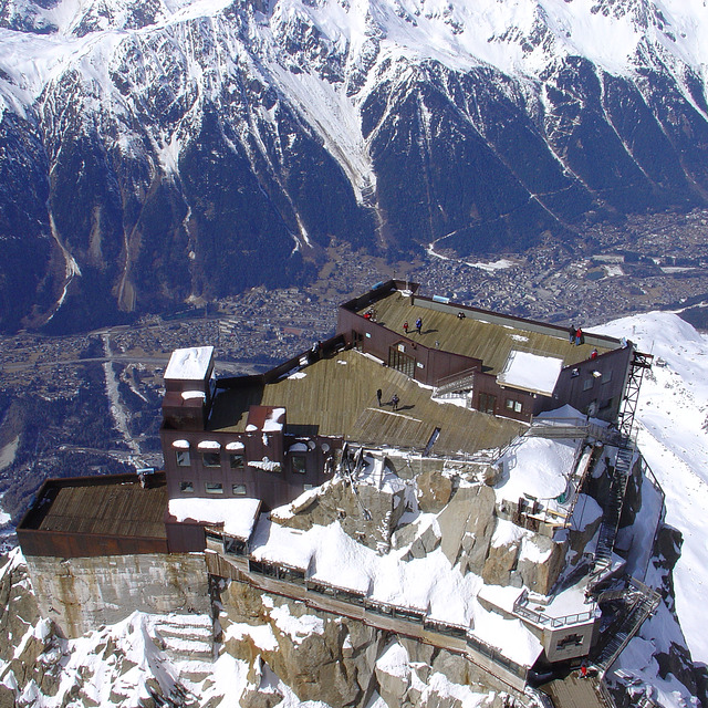
Chamonix Weather (Next 3 days): The snow forecast for Chamonix is: A heavy fall of snow, heaviest during Sun night. Temperatures will be well below freezing (max -6°C on Sun afternoon, min -10°C on Mon night). Wind will be generally light.
Chamonix Weather (Days 4-6): A moderate fall of snow, heaviest on Wed night. Temperatures will be well below freezing (max -9°C on Fri afternoon, min -12°C on Wed night). Wind will be generally light.
| Resort | Snow Depth | Temp. (°C) | Wind (km/h) | Weather | ||
|---|---|---|---|---|---|---|
| Top Lift: | -6 | |||||
| Middle Lift: | 3 | |||||
| Bottom Lift: | 10 |
Latest snow reports near Chamonix:
Light rain reported from Sion at 339 metres elevation 5 kms WNW of Thyon-Printze but it is forecast cold enough for snow at higher elevations in the ski area from Thyon-Printze
Heavy rain reported from Sion at 339 metres elevation 5 kms WNW of Thyon-Printze but it is forecast cold enough for snow at higher elevations in the ski area from Thyon-Printze
Thunderstorm light rain thunderstorm reported from Sion at 339 metres elevation 5 kms WNW of Thyon-Printze but it is forecast cold enough for snow at higher elevations in the ski area from Thyon-Printze

Sun 4 | Monday 5 | Tuesday 6 | Wednesday 7 | Thursday 8 | Friday 9 | Saturday 10 | ||||||||||||||
PM | night | AM | PM | night | AM | PM | night | AM | PM | night | AM | PM | night | AM | PM | night | AM | PM | night | |
light snow | heavy snow | light snow | light snow | light snow | some clouds | snow shwrs | snow shwrs | snow shwrs | light snow | mod. snow | snow shwrs | snow shwrs | clear | clear | light snow | light snow | some clouds | snow shwrs | snow shwrs | |
km/h | ||||||||||||||||||||
Snow map |  |  |  |  |  |  |  | |||||||||||||
3 | 15 | 5 | 3 | 2.0 | — | — | — | — | 4 | 8 | — | — | — | — | 3 | 4 | — | 2.0 | 4 | |
— | — | — | — | — | — | — | — | — | — | — | — | — | — | — | — | — | — | — | — | |
max°C | -6 | -6 | -8 | -9 | -9 | -10 | -9 | -9 | -10 | -10 | -10 | -12 | -10 | -10 | -10 | -9 | -9 | -9 | -8 | -7 |
min°C | -6 | -8 | -9 | -9 | -10 | -10 | -9 | -10 | -10 | -10 | -12 | -12 | -11 | -11 | -10 | -9 | -9 | -9 | -8 | -8 |
-12 | -11 | -9 | -9 | -13 | -14 | -13 | -14 | -14 | -14 | -12 | -15 | -11 | -16 | -14 | -13 | -14 | -9 | -11 | -12 | |
95 | 94 | 99 | 99 | 98 | 94 | 92 | 92 | 96 | 99 | 98 | 94 | 97 | 83 | 82 | 94 | 93 | 90 | 86 | 80 | |
2950 | 2750 | 2500 | 2350 | 2200 | 2350 | 2550 | 2400 | 2350 | 2250 | 2000 | 2050 | 2350 | 2250 | 2450 | 2600 | 2450 | 2600 | 2800 | 2750 | |
— | — | 6:13 | — | — | 6:13 | — | — | 6:11 | — | — | 6:09 | — | — | 6:09 | — | — | 6:07 | — | — | |
— | 8:43 | — | — | 8:44 | — | — | 8:45 | — | — | 8:46 | — | — | 8:47 | — | — | 8:49 | — | — | 8:50 | |
A heavy fall of snow, heaviest during Sun night. Temperatures will be well below freezing (max -6°C on Sun afternoon, min -10°C on Mon night). Wind will be generally light.
A moderate fall of snow, heaviest on Wed night. Temperatures will be well below freezing (max -9°C on Fri afternoon, min -12°C on Wed night). Wind will be generally light.
Latest snow reports near Chamonix:
Light rain reported from Sion at 339 metres elevation 5 kms WNW of Thyon-Printze but it is forecast cold enough for snow at higher elevations in the ski area from Thyon-Printze
Heavy rain reported from Sion at 339 metres elevation 5 kms WNW of Thyon-Printze but it is forecast cold enough for snow at higher elevations in the ski area from Thyon-Printze
Thunderstorm light rain thunderstorm reported from Sion at 339 metres elevation 5 kms WNW of Thyon-Printze but it is forecast cold enough for snow at higher elevations in the ski area from Thyon-Printze
| Top snow depth: | — |
|---|---|
| Bottom snow depth: | — |
| Fresh snowfall depth: | — |
| Last snowfall: | 27 Apr 2025 |
| Snow Alerts | Create Alert |
1.9 | Bluebird Powder days Fresh snow, mostly sunny, light wind. |
|---|---|
1.8 | Powder days Fresh snow, limited sun, any wind. |
2.2 | Bluebird days Average snow, mostly sunny, light wind. |
The above table gives the weather forecast for Chamonix at the specific elevation of 3842 m. Our sophisticated weather models allow us to provide snow forecasts for the top, middle and bottom ski stations of Chamonix. To access the weather forecasts for the other elevations, use the tab navigation above the table. For a wider view of the weather, check out the Weather Map of France.
Click here to read further information on freezing levels and how we forecast our temperatures.
Overall 4.1 Based on 56 votes and 92 reviews
I have been going to Chamonix for several years now, both winter and summer, and it just gets better and better. The thing about Chamonix is not only does it have world class skiing, but it is a bustling beautiful town that has a huge array of bars and restaurants, fantastic varied accommodation and fabulous shops. I like to experience different resorts across Europe but whilst skiing may be great, the off-piste can be limiting and you will only go once. With Chamonix (and a few other bigger resorts) you get an ever changing resort, suitable to budgets of all sizes and plenty to do for non-skiers too. The summer there is also just as good as the winter! If you want a purpose built ski-in / ski-out ski resort, then Chamonix is not for you. If you want the original and authentic ski town, then I can't recommend enough..
Spencer from United Kingdom writes:
I have been going to Chamonix for several years now, both winter and summer, and it just gets better and better. The thing about Chamonix is not only does it have world class skiing, but it is a bustling beautiful town that has a huge array of bars and restaurants, fantastic varied accommodation and fabulous shops. I like to experience different resorts across Europe but whilst skiing may be great, the off-piste can be limiting and you will only go once. With Chamonix (and a few other bigger resorts) you get an ever changing resort, suitable to budgets of all sizes and plenty to do for non-skiers too. The summer there is also just as good as the winter! If you want a purpose built ski-in / ski-out ski resort, then Chamonix is not for you. If you want the original and authentic ski town, then I can't recommend enough..
The Chamonix skiing weather widget is available to embed on external websites free of charge. It provides a daily summary of our Chamonix snow forecast and current weather conditions. Simply go to the feed configuration page and follow the 3 simple steps to grab the custom html code snippet and paste it into your own site. You can choose the snow forecast elevation (summit, mid-mountain or bottom lift) and metric/imperial units for the snow forecast feed to suit your own website…. Click here to get the code.
View detailed snow forecast for Chamonix at:
snow-forecast.com


 Nearest