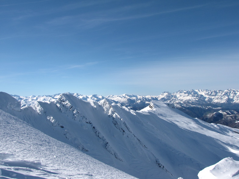


Banff Sunshine Village Opening for Summer Skiing
Banff Sunshine Village has confirmed it will reopen for a fortnight of summer skiing, from this weekend. The only ski area in Canada to be open into July.

Next 3 days weather summary:Light rain (total 3.0mm), mostly falling on Wed night. Warm (max 27°C on Tue afternoon, min 12°C on Thu night). Winds increasing (light winds from the SSE on Wed afternoon, strong winds from the SSW by Thu afternoon). | Days 4-6 weather summary:Light rain (total 2.0mm), mostly falling on Sun night. Warm (max 21°C on Sat afternoon, min 10°C on Sun night). Wind will be generally light. | |||||||||||||||||
Tuesday 23 | Wednesday 24 | Thursday 25 | Friday 26 | Saturday 27 | Sunday 28 | |||||||||||||
AM | PM | night | AM | PM | night | AM | PM | night | AM | PM | night | AM | PM | night | AM | PM | night | |
clear | clear | clear | clear | some clouds | rain shwrs | rain shwrs | some clouds | clear | clear | clear | clear | clear | clear | some clouds | clear | clear | rain shwrs | |
km/h | ||||||||||||||||||
Snow map | 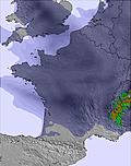 |  | 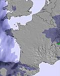 | 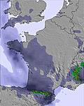 | 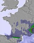 | 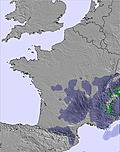 | ||||||||||||
— | — | — | — | — | — | — | — | — | — | — | — | — | — | — | — | — | — | |
mm | — | — | — | — | — | 2 | 1 | — | — | — | — | — | — | — | — | — | — | 2 |
max °C | 25 | 27 | 25 | 24 | 26 | 22 | 19 | 20 | 16 | 17 | 20 | 19 | 18 | 21 | 18 | 15 | 19 | 12 |
min °C | 21 | 27 | 21 | 21 | 26 | 18 | 17 | 19 | 12 | 13 | 19 | 14 | 15 | 20 | 11 | 11 | 18 | 10 |
chill °C | 21 | 27 | 21 | 21 | 26 | 18 | 16 | 18 | 11 | 12 | 18 | 13 | 14 | 20 | 10 | 11 | 18 | 10 |
Humid % | 18 | 19 | 23 | 28 | 25 | 38 | 48 | 39 | 52 | 53 | 43 | 42 | 48 | 40 | 80 | 73 | 68 | 81 |
Freeze m | 4750 | 4750 | 4750 | 4650 | 4700 | 4650 | 4350 | 4050 | 4100 | 4050 | 3950 | 4150 | 4050 | 4150 | 4350 | 4250 | 4300 | 4300 |
6:37 | — | — | 6:37 | — | — | 6:39 | — | — | 6:39 | — | — | 6:39 | — | — | 6:39 | — | — | |
— | — | 10:00 | — | — | 10:00 | — | — | 10:00 | — | — | 10:00 | — | — | 10:00 | — | — | 10:00 | |
Go pro and carve into:
Avalanche information: European Avalanche Warning Services (EAWS)
Latest snow reports near Alto Campoo:
| Top snow depth: | — |
|---|---|
| Bottom snow depth: | — |
| Fresh snowfall depth: | — |
| Last snowfall: | 15 May 2026 |
| Snow Alerts | Create Alert |
0.0 | Bluebird Powder days Fresh snow, mostly sunny, light wind. |
|---|---|
0.0 | Powder days Fresh snow, limited sun, any wind. |
0.0 | Bluebird days Average snow, mostly sunny, light wind. |
The above table gives the weather forecast for Alto Campoo at the specific elevation of 1649 m. Our sophisticated weather models allow us to provide snow forecasts for the top, middle and bottom ski stations of Alto Campoo. To access the weather forecasts for the other elevations, use the tab navigation above the table. For a wider view of the weather, check out the Weather Map of Spain.
Click here to read further information on freezing levels and how we forecast our temperatures.
Overall 3.2 Based on 115 votes and 81 reviews
Hioy dia 8 de Febrero y con un dia maravilloso y con una increible nieve polvo hemos subido a disfrutar el dia Hubiera sido mucho mas divertido si hubieran pisado las pistas. Subimos a Tres Mares y aquello parecia un patatal. Lo mismo los Asnos, los Castros y el Cuchillon. El remonte del Cuchillon sigue siendo el mismo, quiero decir que en un dia como hoy de poca gente, hemos tardado una hora en hacer dos bajadas. Infumable.
Pilar from Spain writes:
Hioy dia 8 de Febrero y con un dia maravilloso y con una increible nieve polvo hemos subido a disfrutar el dia Hubiera sido mucho mas divertido si hubieran pisado las pistas. Subimos a Tres Mares y aquello parecia un patatal. Lo mismo los Asnos, los Castros y el Cuchillon. El remonte del Cuchillon sigue siendo el mismo, quiero decir que en un dia como hoy de poca gente, hemos tardado una hora en hacer dos bajadas. Infumable.


 Nearest