

Global Weekly Snow Roundup #314
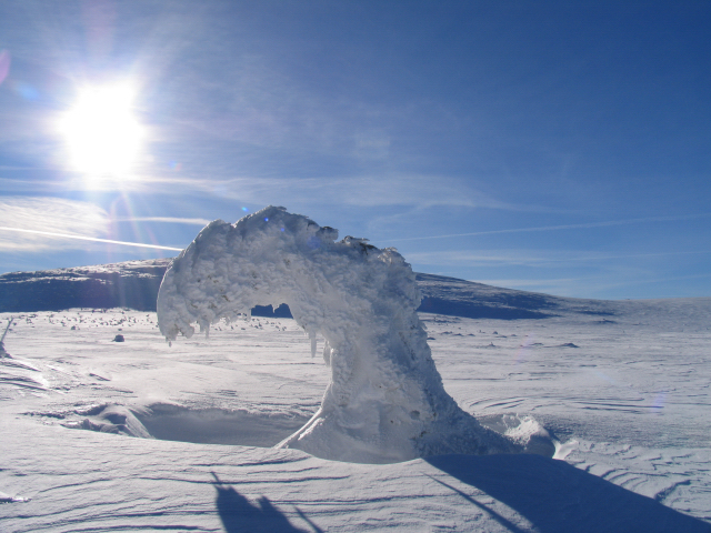
Weekly Global Snow News, updated 14 May 2026: Fresh snowfall in Argentina, Australia and Lesotho signals winter’s approach, while Japan maintains the world’s deepest snowpack.

Next 3 days weather summary:Light rain (total 7.0mm), mostly falling on Sat afternoon. Very mild (max 11°C on Mon afternoon, min 4°C on Sat night). Wind will be generally light. | Days 4-6 weather summary:Heavy rain (total 20.0mm), heaviest during Thu afternoon. Very mild (max 12°C on Thu afternoon, min 7°C on Wed night). Wind will be generally light. | ||||||||||||||||
Sat 16 | Sunday 17 | Monday 18 | Tuesday 19 | Wednesday 20 | Thursday 21 | ||||||||||||
PM | night | AM | PM | night | AM | PM | night | AM | PM | night | AM | PM | night | AM | PM | night | |
light rain | light rain | cloudy | light rain | rain shwrs | clear | some clouds | light rain | light rain | risk thun- der | rain shwrs | light rain | rain shwrs | rain shwrs | light rain | risk thun- der | rain shwrs | |
km/h | |||||||||||||||||
Snow map |  |  |  | 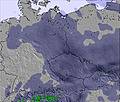 | 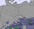 | 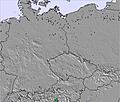 | |||||||||||
— | — | — | — | — | — | — | — | — | — | — | — | — | — | — | — | — | |
2 | 1 | — | 1 | 1 | — | — | 1 | 1 | 4 | 1 | 1 | 2 | 1 | 1 | 4 | 3 | |
max °C | 6 | 5 | 6 | 8 | 7 | 8 | 11 | 10 | 11 | 10 | 10 | 8 | 10 | 10 | 10 | 12 | 11 |
min °C | 5 | 4 | 5 | 8 | 5 | 6 | 10 | 8 | 9 | 10 | 8 | 8 | 10 | 7 | 9 | 12 | 8 |
2 | 1 | 3 | 6 | 4 | 5 | 10 | 7 | 9 | 9 | 6 | 6 | 7 | 5 | 8 | 11 | 6 | |
92 | 78 | 73 | 74 | 76 | 66 | 61 | 78 | 70 | 78 | 84 | 87 | 79 | 85 | 84 | 86 | 84 | |
1750 | 1800 | 1700 | 1900 | 1950 | 2050 | 2250 | 2300 | 2300 | 2450 | 2400 | 2300 | 2500 | 2450 | 2450 | 2700 | 2600 | |
— | — | 5:05 | — | — | 5:03 | — | — | 5:01 | — | — | 5:01 | — | — | 5:00 | — | — | |
— | 8:35 | — | — | 8:37 | — | — | 8:37 | — | — | 8:38 | — | — | 8:40 | — | — | 8:42 | |
Latest snow reports near Zieleniec:
| Top snow depth: | — |
|---|---|
| Bottom snow depth: | — |
| Fresh snowfall depth: | — |
| Last snowfall: | 11 May 2026 |
| Snow Alerts | Create Alert |
0.0 | Bluebird Powder days Fresh snow, mostly sunny, light wind. |
|---|---|
0.0 | Powder days Fresh snow, limited sun, any wind. |
0.0 | Bluebird days Average snow, mostly sunny, light wind. |
The above table gives the weather forecast for Zieleniec at the specific elevation of 935 m. Our sophisticated weather models allow us to provide snow forecasts for the top, middle and bottom ski stations of Zieleniec. To access the weather forecasts for the other elevations, use the tab navigation above the table. For a wider view of the weather, check out the Weather Map of Poland.
Click here to read further information on freezing levels and how we forecast our temperatures.
Overall 2.5 Based on 10 votes and 3 reviews
Zieleniec is a great resort for learner and beginner skiers/boarders. It's also good for more experienced riders looking to break in the legs prior to a real holiday. They have two new chairlifts built in 2008 making three in total and plenty of other drags accessing many other runs. Basically the whole resort is on one side of a hill, Czech Republic being the other side. Zieleniec has a surprisingly decent snow park near the church at the bottom and three big air hits on the first run as you drive in to resort, a 5, 10 and 15 m hit, they're not too user friendly but there if you have the skills. The drag lift accessing these is only open on weekends. They dug out a Half pipe in 2008, this should be open for the 09/10 season. Due to the unreliable climate in Poland snow conditions vary considerably.
The Dude from United Kingdom writes:
Zieleniec is a great resort for learner and beginner skiers/boarders. It's also good for more experienced riders looking to break in the legs prior to a real holiday. They have two new chairlifts built in 2008 making three in total and plenty of other drags accessing many other runs. Basically the whole resort is on one side of a hill, Czech Republic being the other side.
Zieleniec has a surprisingly decent snow park near the church at the bottom and three big air hits on the first run as you drive in to resort, a 5, 10 and 15 m hit, they're not too user friendly but there if you have the skills. The drag lift accessing these is only open on weekends. They dug out a Half pipe in 2008, this should be open for the 09/10 season.
Due to the unreliable climate in Poland snow conditions vary considerably.


 Nearest