

Global Weekly Snow Roundup #314
Weekly Global Snow News, updated 14 May 2026: Fresh snowfall in Argentina, Australia and Lesotho signals winter’s approach, while Japan maintains the world’s deepest snowpack.

Next 3 days weather summary:A light covering of new snow, mostly falling on Mon afternoon. Temperatures will be below freezing (max -1°C on Sun afternoon, min -9°C on Sat morning). Wind will be generally light. | Days 4-6 weather summary:A dusting of new snow. Freeze-thaw conditions (max 8°C on Thu night, min -1°C on Tue morning). Wind will be generally light. | |||||||||||||||||
Saturday 16 | Sunday 17 | Monday 18 | Tuesday 19 | Wednesday 20 | Thursday 21 | |||||||||||||
AM | PM | night | AM | PM | night | AM | PM | night | AM | PM | night | AM | PM | night | AM | PM | night | |
light snow | snow shwrs | snow shwrs | some clouds | cloudy | snow shwrs | light snow | snow shwrs | light snow | cloudy | light snow | snow shwrs | clear | some clouds | some clouds | some clouds | some clouds | clear | |
km/h | ||||||||||||||||||
Snow map |  |  |  |  |  |  | ||||||||||||
— | 1 | — | — | — | — | — | 2 | 2 | — | 1 | — | — | — | — | — | — | — | |
— | — | — | — | — | — | — | — | — | — | — | — | — | — | — | — | — | — | |
max °C | -8 | -6 | -4 | -2 | -1 | -1 | -3 | -2 | -2 | -1 | 0 | 1 | 2 | 4 | 4 | 6 | 7 | 8 |
min °C | -9 | -7 | -6 | -3 | -2 | -3 | -3 | -2 | -3 | -1 | -1 | 0 | 1 | 3 | 4 | 4 | 7 | 7 |
-13 | -11 | -8 | -3 | -5 | -8 | -8 | -8 | -8 | -4 | -5 | -3 | -1 | 1 | 3 | 3 | 6 | 7 | |
89 | 85 | 64 | 28 | 82 | 80 | 91 | 85 | 95 | 86 | 96 | 72 | 66 | 68 | 46 | 26 | 32 | 23 | |
1600 | 1900 | 1550 | 2300 | 2500 | 2200 | 2250 | 2300 | 2150 | 2500 | 2650 | 2700 | 2950 | 3100 | 3450 | 3650 | 3700 | 4050 | |
5:58 | — | — | 5:58 | — | — | 5:56 | — | — | 5:56 | — | — | 5:54 | — | — | 5:54 | — | — | |
— | — | 8:59 | — | — | 9:00 | — | — | 9:00 | — | — | 9:01 | — | — | 9:04 | — | — | 9:05 | |
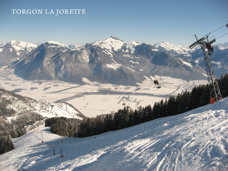
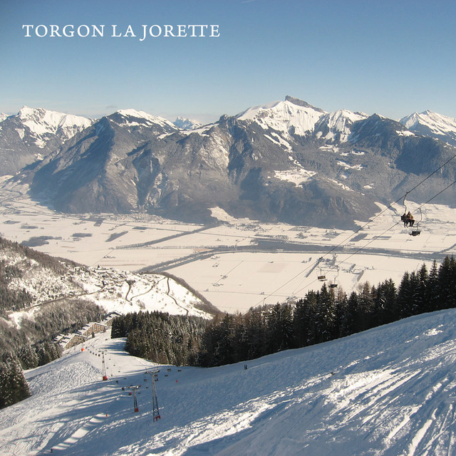
Latest snow reports near Torgon-Les Portes du Soleil:
| Top snow depth: | — |
|---|---|
| Bottom snow depth: | — |
| Fresh snowfall depth: | 18 cm |
| Last snowfall: | 15 May 2026 |
| Snow Alerts | Create Alert |
0.2 | Bluebird Powder days Fresh snow, mostly sunny, light wind. |
|---|---|
0.9 | Powder days Fresh snow, limited sun, any wind. |
0.3 | Bluebird days Average snow, mostly sunny, light wind. |
The above table gives the weather forecast for Torgon-Les Portes du Soleil at the specific elevation of 2613 m. Our sophisticated weather models allow us to provide snow forecasts for the top, middle and bottom ski stations of Torgon-Les Portes du Soleil. To access the weather forecasts for the other elevations, use the tab navigation above the table. For a wider view of the weather, check out the Weather Map of Switzerland.
Click here to read further information on freezing levels and how we forecast our temperatures.
Overall 3.9 Based on 11 votes and 9 reviews
In Torgon de voorjaarsvakantie 2013 doorgebracht tijdens een ongelooflijk fraaie zonnige week met extreem veel sneeuw. Geen wachttijden bij de liften. Top geprepareerde pistes. Het mooie van Torgon zijn de uitdagende pistes. Het is niet nodig de portes du soleil in te trekken. Genoeg variatie in Torgon. La Jorette is een uitdagende piste met een fraaie hellingshoek. Le Djeu des Tetes is iets eenvoudiger maar ook spannend genoeg. Le Tronchey is zeer uitdagend. Mijn idee steiler dan de muur bij Crosets. Dan de Braitaz bij Chapelle. Vol op de zon met in het begin een schitterende helling om te carven. In Torgon genoeg tentjes om te lunchen. Le Tseudron, La Bourri, Le Mousseron, Les Aiguilletes, La Panoramique (met uitzicht over het meer van Geneve). Apres-ski in Le Perroquet of de Chocolat-Bar of Le Verre a Soi, Les Caprins. 2 snowparks op Le Braitaz en Djeu des Tetes. Kortom genoeg voorh et hele gezin. Absolute aanrader. Job
Job from Netherlands writes:
In Torgon de voorjaarsvakantie 2013 doorgebracht tijdens een ongelooflijk fraaie zonnige week met extreem veel sneeuw. Geen wachttijden bij de liften. Top geprepareerde pistes. Het mooie van Torgon zijn de uitdagende pistes. Het is niet nodig de portes du soleil in te trekken. Genoeg variatie in Torgon. La Jorette is een uitdagende piste met een fraaie hellingshoek. Le Djeu des Tetes is iets eenvoudiger maar ook spannend genoeg. Le Tronchey is zeer uitdagend. Mijn idee steiler dan de muur bij Crosets. Dan de Braitaz bij Chapelle. Vol op de zon met in het begin een schitterende helling om te carven. In Torgon genoeg tentjes om te lunchen. Le Tseudron, La Bourri, Le Mousseron, Les Aiguilletes, La Panoramique (met uitzicht over het meer van Geneve). Apres-ski in Le Perroquet of de Chocolat-Bar of Le Verre a Soi, Les Caprins. 2 snowparks op Le Braitaz en Djeu des Tetes. Kortom genoeg voorh et hele gezin. Absolute aanrader. Job
Read 8 more reviews of Torgon-Les Portes du Soleil or submit your own


 Nearest