

Global Weekly Snow Roundup #314
Weekly Global Snow News, updated 14 May 2026: Fresh snowfall in Argentina, Australia and Lesotho signals winter’s approach, while Japan maintains the world’s deepest snowpack.

Next 3 days weather summary:A dusting of snow giving way to moderate rain (total 18.0mm) heaviest on Mon night. Freeze-thaw conditions (max 11°C on Mon afternoon, min 0°C on Sat morning). Wind will be generally light. | Days 4-6 weather summary:Heavy rain (total 21.0mm), heaviest during Tue night. Very mild (max 14°C on Thu afternoon, min 5°C on Tue morning). Wind will be generally light. | |||||||||||||||||
Saturday 16 | Sunday 17 | Monday 18 | Tuesday 19 | Wednesday 20 | Thursday 21 | |||||||||||||
AM | PM | night | AM | PM | night | AM | PM | night | AM | PM | night | AM | PM | night | AM | PM | night | |
light snow | light snow | rain shwrs | clear | rain shwrs | rain shwrs | rain shwrs | risk thun- der | mod. rain | some clouds | light rain | light rain | light rain | rain shwrs | light rain | rain shwrs | rain shwrs | rain shwrs | |
km/h | ||||||||||||||||||
Snow map |  |  |  |  |  |  | ||||||||||||
3 | — | — | — | — | — | — | — | — | — | — | — | — | — | — | — | — | — | |
— | 1 | 1 | — | 1 | 1 | 1 | 3 | 10 | — | 2 | 5 | 3 | 3 | 4 | 1 | 2 | 1 | |
max °C | 0 | 2 | 2 | 4 | 8 | 7 | 9 | 11 | 7 | 8 | 10 | 7 | 8 | 8 | 9 | 9 | 14 | 12 |
min °C | 0 | 1 | 1 | 2 | 7 | 6 | 7 | 10 | 5 | 5 | 10 | 7 | 8 | 8 | 8 | 8 | 11 | 9 |
-2 | 1 | 1 | 2 | 7 | 6 | 7 | 10 | 3 | 5 | 10 | 6 | 8 | 7 | 7 | 8 | 11 | 9 | |
99 | 94 | 90 | 77 | 63 | 72 | 63 | 63 | 91 | 76 | 75 | 92 | 85 | 83 | 85 | 82 | 55 | 87 | |
1300 | 1600 | 1600 | 1900 | 2300 | 2250 | 2400 | 2550 | 2150 | 2400 | 2650 | 2550 | 2500 | 2600 | 2550 | 2600 | 2950 | 2900 | |
5:33 | — | — | 5:31 | — | — | 5:31 | — | — | 5:30 | — | — | 5:28 | — | — | 5:28 | — | — | |
— | — | 8:42 | — | — | 8:43 | — | — | 8:44 | — | — | 8:45 | — | — | 8:46 | — | — | 8:47 | |
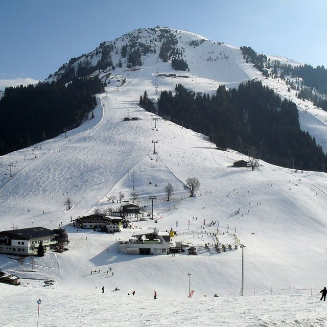
Latest snow reports near Söll (SkiWelt):
| Top snow depth: | — |
|---|---|
| Bottom snow depth: | — |
| Fresh snowfall depth: | 16 cm |
| Last snowfall: | 15 May 2026 |
| Snow Alerts | Create Alert |
0.0 | Bluebird Powder days Fresh snow, mostly sunny, light wind. |
|---|---|
0.0 | Powder days Fresh snow, limited sun, any wind. |
0.0 | Bluebird days Average snow, mostly sunny, light wind. |
The above table gives the weather forecast for Söll (SkiWelt) at the specific elevation of 1288 m. Our sophisticated weather models allow us to provide snow forecasts for the top, middle and bottom ski stations of Söll (SkiWelt). To access the weather forecasts for the other elevations, use the tab navigation above the table. For a wider view of the weather, check out the Weather Map of Austria.
Click here to read further information on freezing levels and how we forecast our temperatures.
Resort name is also written as Soll.
Overall 4.2 Based on 36 votes and 52 reviews
The Ski Welt is one of the biggest and best ski areas in Austria. The lift system is efficient and modern. It is really an intermediates paradise. There are a number of black runs and reasonable off-piste for experts. Those new to the sport have many blues to explore but limited facilities for beginners in the village of Söll itself and the home mountain (Hohe Salve) has a long blue into town, but otherwise more for experienced skiers. Mountain restaurants in the whole area are excellent and plentiful. Söll itself used to be quite a lively resort in the evenings but in the last 3 or 4 years has quietened down a lot to the extent nightlife is almost non existent apart from a few bars, a couple with live music some days. The resort made a decision to focus on families.
Stephen Henry from United Kingdom writes:
The Ski Welt is one of the biggest and best ski areas in Austria. The lift system is efficient and modern. It is really an intermediates paradise. There are a number of black runs and reasonable off-piste for experts. Those new to the sport have many blues to explore but limited facilities for beginners in the village of Söll itself and the home mountain (Hohe Salve) has a long blue into town, but otherwise more for experienced skiers. Mountain restaurants in the whole area are excellent and plentiful. Söll itself used to be quite a lively resort in the evenings but in the last 3 or 4 years has quietened down a lot to the extent nightlife is almost non existent apart from a few bars, a couple with live music some days. The resort made a decision to focus on families.


 Nearest