


View forecast
Snowy Range Ski and Recreation Area at 3045 m altitude
Issued by Snow-Forecast.com at: 5 am (local time) / 26 Apr 2024
Now
Friday 26 | Saturday 27 | Sunday 28 | Monday 29 | Tuesday 30 | Wednesday 1 | Thursday 2 | |||||||||||||||
AM | PM | night | AM | PM | night | AM | PM | night | AM | PM | night | AM | PM | night | AM | PM | night | AM | PM | night | |
cloudy | light snow | light snow | light snow | light snow | light snow | some clouds | snow shwrs | clear | some clouds | some clouds | snow shwrs | some clouds | some clouds | rain shwrs | snow shwrs | snow shwrs | some clouds | light snow | cloudy | clear | |
km/h | |||||||||||||||||||||
Snow map | 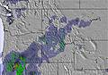 | 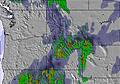 | 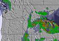 |  |  |  |  | ||||||||||||||
— | 1.0 | 5 | 4 | 4 | 2.0 | — | — | — | — | — | — | — | — | — | — | — | — | — | — | — | |
— | 1.0 | — | — | — | — | — | — | — | — | — | — | — | — | 1.0 | — | — | — | — | — | — | |
max°C | 1 | 2 | 0 | -3 | -4 | -4 | -2 | 1 | 1 | 1 | 4 | 0 | 2 | 7 | 3 | -5 | -5 | -6 | -5 | -1 | -2 |
min°C | -1 | 1 | -3 | -3 | -4 | -5 | -4 | 0 | -2 | -2 | 4 | -3 | -2 | 5 | -2 | -7 | -6 | -9 | -8 | -3 | -3 |
-9 | -4 | -10 | -12 | -13 | -9 | -12 | -8 | -12 | -11 | -3 | -11 | -11 | -2 | -10 | -19 | -18 | -19 | -16 | -10 | -6 | |
77 | 62 | 86 | 98 | 98 | 98 | 83 | 75 | 58 | 72 | 53 | 79 | 56 | 38 | 62 | 74 | 61 | 61 | 95 | 48 | 59 | |
2900 | 3350 | 2850 | 2600 | 2450 | 2250 | 2400 | 3000 | 2850 | 2850 | 3550 | 2800 | 2800 | 3650 | 3500 | 2350 | 2400 | 2000 | 2050 | 2750 | 2450 | |
6:05 | — | — | 6:03 | — | — | 6:03 | — | — | 6:01 | — | — | 6:00 | — | — | 5:58 | — | — | 5:56 | — | — | |
— | 7:54 | — | — | 7:55 | — | — | 7:57 | — | — | 7:58 | — | — | 7:59 | — | — | 8:00 | — | — | 8:00 | — | |
Next 0-3 days weather summary:
Drizzle on Fri afternoon followed by colder weather and a moderate fall of snow, heaviest on Fri night. Freeze-thaw conditions (max 2°C on Fri afternoon, min -5°C on Sat night). Winds increasing (light winds from the NNE on Sat night, near gales from the W by Sun night).
Next 4-6 days weather summary:
Drizzle at first, then turning colder with dusting of snow on Wed morning. Freeze-thaw conditions (max 7°C on Tue afternoon, min -9°C on Wed night). Mainly gales.
Popular Snowy Range Ski and Recreation Area Pages
Snow Radar
Latest snow reports near Snowy Range Ski and Recreation Area:
Snowy Range Ski and Recreation Area Snow Conditions
| Top snow depth: | — |
|---|---|
| Bottom snow depth: | — |
| Fresh snowfall depth: | — |
| Last snowfall: | 20 Apr 2024 |
| Snow Alerts | Create Alert |
Other resorts in USA - Wyoming are reporting: powder (0) / good piste (0)
Snow-Forecast Partner Offers
Show your business here
Snow History
Week 4 of April has on average:
0.1 | Bluebird Powder days Fresh snow, mostly sunny, light wind. |
|---|---|
1.5 | Powder days Fresh snow, limited sun, any wind. |
0.4 | Bluebird days Average snow, mostly sunny, light wind. |

Snowy Range Ski and Recreation Area Forecast Snowfall


Other resorts in USA - Wyoming are reporting: powder (0) / good piste (0)
The above table gives the weather forecast for Snowy Range Ski and Recreation Area at the specific elevation of 3045 m. Our sophisticated weather models allow us to provide snow forecasts for the top, middle and bottom ski stations of Snowy Range Ski and Recreation Area. To access the weather forecasts for the other elevations, use the tab navigation above the table. For a wider view of the weather, check out the Weather Map of United States.
Click here to read further information on freezing levels and how we forecast our temperatures.
Visitor Reviews of Snowy Range Ski and Recreation Area
- Torak from United States writes:
My first skiing experience was when I was 14 years old. That wasn't very long ago so I still remember everything. I came to snowy range with some family and had the time of my life. Skiing turned out to be my favorite memory of my life. Snowy Range has great helpers. I took ski lessons and learned a lot. My 2nd year, my cousin and I wore these outrageous hats, which we have made an annual thing, and the person running the ski lift at the top threw snowballs at us. The next we were prepared and had our own snowballs. The staff are friendly and it was the perfect place for me to grow up learning skiing. I took to skiing right away. The trails have about everything you could ever want from them. They have bumpy and smooth trails. They have nice long relaxing ones and really fun twisty trails.
Visitor Reviews of Snowy Range Ski and Recreation Area
Torak from United States writes:
My first skiing experience was when I was 14 years old. That wasn't very long ago so I still remember everything. I came to snowy range with some family and had the time of my life. Skiing turned out to be my favorite memory of my life. Snowy Range has great helpers. I took ski lessons and learned a lot. My 2nd year, my cousin and I wore these outrageous hats, which we have made an annual thing, and the person running the ski lift at the top threw snowballs at us. The next we were prepared and had our own snowballs. The staff are friendly and it was the perfect place for me to grow up learning skiing. I took to skiing right away. The trails have about everything you could ever want from them. They have bumpy and smooth trails. They have nice long relaxing ones and really fun twisty trails.
Read 1 more reviews of Snowy Range Ski and Recreation Area or submit your own
Free Snow-Forecast.com weather widget for your website
The Snowy Range Ski and Recreation Area skiing weather widget is available to embed on external websites free of charge. It provides a daily summary of our Snowy Range Ski and Recreation Area snow forecast and current weather conditions. Simply go to the feed configuration page and follow the 3 simple steps to grab the custom html code snippet and paste it into your own site. You can choose the snow forecast elevation (summit, mid-mountain or bottom lift) and metric/imperial units for the snow forecast feed to suit your own website…. Click here to get the code.
View detailed snow forecast for Snowy Range Ski and Recreation Area at:
snow-forecast.com

 Nearest