

Global Weekly Snow Roundup #318
Weekly Snow News for the world, updated 11 June 2026: Australia's season begins, Val d’Isère reopens and major snowfall is forecast for the Andes.

Next 3 days weather summary:Light rain (total 3.0mm), mostly falling on Fri morning. Very mild (max 13°C on Sun afternoon, min 1°C on Fri morning). Wind will be generally light. | Days 4-6 weather summary:Moderate rain (total 17.0mm), heaviest on Tue afternoon. Very mild (max 13°C on Mon afternoon, min 4°C on Tue night). Winds decreasing (fresh winds from the WNW on Tue afternoon, calm by Wed night). | |||||||||||||||||
Friday 12 | Saturday 13 | Sunday 14 | Monday 15 | Tuesday 16 | Wednesday 17 | |||||||||||||
AM | PM | night | AM | PM | night | AM | PM | night | AM | PM | night | AM | PM | night | AM | PM | night | |
snow shwrs | light rain | clear | rain shwrs | some clouds | some clouds | clear | some clouds | some clouds | cloudy | cloudy | rain shwrs | t-storm risk | rain shwrs | rain shwrs | clear | some clouds | clear | |
km/h | ||||||||||||||||||
Snow map | 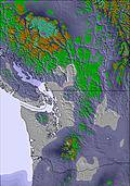 | 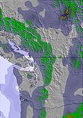 | 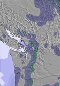 | 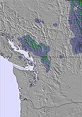 | 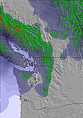 | 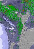 | ||||||||||||
— | — | — | — | — | — | — | — | — | — | — | — | — | — | — | — | — | — | |
1 | 1 | — | 1 | — | — | — | — | — | — | — | 3 | 6 | 7 | 1 | — | — | — | |
max °C | 3 | 6 | 5 | 6 | 9 | 9 | 10 | 13 | 12 | 12 | 13 | 10 | 8 | 9 | 7 | 7 | 10 | 10 |
min °C | 1 | 5 | 3 | 3 | 8 | 6 | 7 | 12 | 10 | 10 | 13 | 7 | 8 | 8 | 4 | 5 | 10 | 6 |
-1 | 3 | 3 | 3 | 8 | 6 | 7 | 12 | 10 | 9 | 12 | 4 | 5 | 4 | 2 | 3 | 8 | 6 | |
66 | 66 | 73 | 67 | 53 | 56 | 48 | 47 | 54 | 52 | 59 | 82 | 78 | 65 | 60 | 57 | 46 | 53 | |
2600 | 2850 | 2750 | 2850 | 3150 | 3250 | 3300 | 3750 | 4000 | 3850 | 4000 | 3700 | 3400 | 3050 | 3000 | 3000 | 3450 | 3500 | |
4:37 | — | — | 4:37 | — | — | 4:37 | — | — | 4:37 | — | — | 4:37 | — | — | 4:37 | — | — | |
— | — | 9:06 | — | — | 9:07 | — | — | 9:07 | — | — | 9:07 | — | — | 9:07 | — | — | 9:08 | |
Go pro and carve into:
Avalanche information: Avalanche Canada
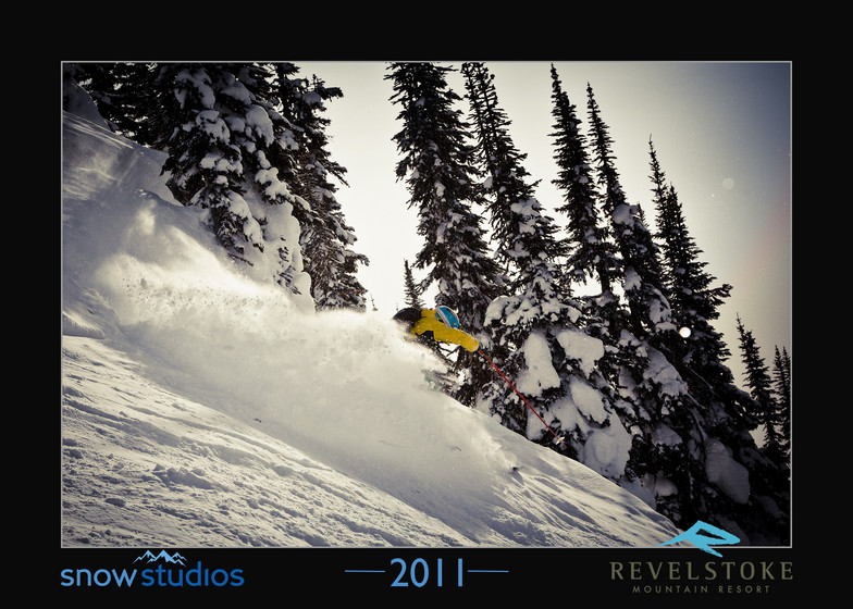
Latest snow reports near Revelstoke Mountain Resort:
| Top snow depth: | 0 cm |
|---|---|
| Bottom snow depth: | 0 cm |
| Fresh snowfall depth: | — |
| Last snowfall: | 19 May 2026 |
| Snow Alerts | Create Alert |
0.1 | Bluebird Powder days Fresh snow, mostly sunny, light wind. |
|---|---|
0.6 | Powder days Fresh snow, limited sun, any wind. |
0.0 | Bluebird days Average snow, mostly sunny, light wind. |
The above table gives the weather forecast for Revelstoke Mountain Resort at the specific elevation of 2225 m. Our sophisticated weather models allow us to provide snow forecasts for the top, middle and bottom ski stations of Revelstoke Mountain Resort. To access the weather forecasts for the other elevations, use the tab navigation above the table. For a wider view of the weather, check out the Weather Map of Canada.
Click here to read further information on freezing levels and how we forecast our temperatures.
Overall 3.4 Based on 76 votes and 111 reviews
Skied first time there for 3 days end of December 2024. Positives: seems to be snowsure mid-mountain and upper, unreal/fun terrain and tree runs (Ripper chair all day), base village is very close to Town (8 min drive to downtown), quiet runs (rarely saw a soul off Ripper in the trees), warm temps usually Neutrals: intermediate-advanced only (if you want to have any fun), sidecountry has great runs but can get cliffed out, gondola line bottleneck can be a wait on a good snow day if you're there late. Negatives: perennial fog and poorly marked mountain means getting lost often. Skied around 10 resorts in CA and EU and never seen fog so bad. Locals commented the good runs were 'gatekept' and it felt like that. Would recommend this hill to someone who books trips in advance. Great chance of having good conditions, but would tell first-timers to get a lesson or guide to show them around. I felt like I missed out on a lot as the runs are poorly marked (then you add on fog), and a lot of the "good" spots are tough to traverse to and back. Especially because everything around mid-mountain and lower had bad conditions, so you don't prefer to end up down there. That, with the short lift hours, makes for a short day if you're bumbling around looking for the right run. I'm a level 6 advanced skier of 20 yrs, but this is a steep drop and it messes with your mind. It was super fun, but I was skiing cautious b/c I didn't ever know where I was, and locals warned me you can get cliffed out in a few areas. Whole town and resort feels like a fun local hill where their infrastructure hasn't kept up with the demand a little. All that being said, I can't wait to get back and find my bearings, I did the same chair (Ripper) for 3 days and had a blast and would do it again, though looking forward to exploring more of the hill.
Kloey from Canada writes:
Skied first time there for 3 days end of December 2024.
Positives: seems to be snowsure mid-mountain and upper, unreal/fun terrain and tree runs (Ripper chair all day), base village is very close to Town (8 min drive to downtown), quiet runs (rarely saw a soul off Ripper in the trees), warm temps usually
Neutrals: intermediate-advanced only (if you want to have any fun), sidecountry has great runs but can get cliffed out, gondola line bottleneck can be a wait on a good snow day if you're there late.
Negatives: perennial fog and poorly marked mountain means getting lost often. Skied around 10 resorts in CA and EU and never seen fog so bad. Locals commented the good runs were 'gatekept' and it felt like that.
Would recommend this hill to someone who books trips in advance. Great chance of having good conditions, but would tell first-timers to get a lesson or guide to show them around.
I felt like I missed out on a lot as the runs are poorly marked (then you add on fog), and a lot of the "good" spots are tough to traverse to and back. Especially because everything around mid-mountain and lower had bad conditions, so you don't prefer to end up down there. That, with the short lift hours, makes for a short day if you're bumbling around looking for the right run.
I'm a level 6 advanced skier of 20 yrs, but this is a steep drop and it messes with your mind. It was super fun, but I was skiing cautious b/c I didn't ever know where I was, and locals warned me you can get cliffed out in a few areas.
Whole town and resort feels like a fun local hill where their infrastructure hasn't kept up with the demand a little.
All that being said, I can't wait to get back and find my bearings, I did the same chair (Ripper) for 3 days and had a blast and would do it again, though looking forward to exploring more of the hill.
Read 110 more reviews of Revelstoke Mountain Resort or submit your own


 Nearest