

Global Weekly Snow Roundup #314
Weekly Global Snow News, updated 14 May 2026: Fresh snowfall in Argentina, Australia and Lesotho signals winter’s approach, while Japan maintains the world’s deepest snowpack.

Next 3 days weather summary:Mostly dry. Mild temperatures (max 6°C on Sat afternoon, min 4°C on Mon night). Wind will be generally light. | Days 4-6 weather summary:Heavy rain (total 48.0mm), heaviest during Fri morning. Mild temperatures (max 5°C on Tue afternoon, min 3°C on Thu afternoon). Winds increasing (light winds from the NW on Tue afternoon, fresh winds from the NNW by Fri morning). | ||||||||||||||||
Sat 16 | Sunday 17 | Monday 18 | Tuesday 19 | Wednesday 20 | Thursday 21 | ||||||||||||
PM | night | AM | PM | night | AM | PM | night | AM | PM | night | AM | PM | night | AM | PM | night | |
clear | clear | clear | clear | clear | clear | clear | clear | some clouds | some clouds | cloudy | cloudy | cloudy | cloudy | cloudy | some clouds | mod. rain | |
km/h | |||||||||||||||||
Snow map |  |  |  |  |  |  | |||||||||||
— | — | — | — | — | — | — | — | — | — | — | — | — | — | — | — | — | |
— | — | — | — | — | — | — | — | — | — | — | — | — | — | — | — | 8 | |
max °C | 6 | 6 | 6 | 6 | 5 | 5 | 5 | 5 | 5 | 5 | 5 | 5 | 5 | 5 | 4 | 3 | 5 |
min °C | 6 | 6 | 6 | 5 | 5 | 5 | 5 | 4 | 4 | 4 | 5 | 5 | 4 | 4 | 4 | 3 | 3 |
6 | 6 | 6 | 5 | 5 | 4 | 4 | 4 | 2 | 2 | 3 | 2 | 1 | 1 | 1 | -1 | -1 | |
31 | 17 | 22 | 40 | 37 | 20 | 35 | 25 | 13 | 33 | 18 | 23 | 35 | 24 | 70 | 86 | 94 | |
2950 | 2900 | 2800 | 2750 | 2650 | 2600 | 2600 | 2600 | 2800 | 2700 | 2950 | 3000 | 3100 | 2750 | 2550 | 2050 | 2850 | |
— | — | 7:50 | — | — | 7:52 | — | — | 7:52 | — | — | 7:54 | — | — | 7:54 | — | — | |
5:23 | — | — | 5:22 | — | — | 5:22 | — | — | 5:21 | — | — | 5:20 | — | — | 5:19 | — | |
Latest snow reports near Ohau:
| Top snow depth: | — |
|---|---|
| Bottom snow depth: | — |
| Fresh snowfall depth: | — |
| Last snowfall: | 8 May 2026 |
| Snow Alerts | Create Alert |
0.6 | Bluebird Powder days Fresh snow, mostly sunny, light wind. |
|---|---|
0.6 | Powder days Fresh snow, limited sun, any wind. |
0.3 | Bluebird days Average snow, mostly sunny, light wind. |

The above table gives the weather forecast for Ohau at the specific elevation of 1625 m. Our sophisticated weather models allow us to provide snow forecasts for the top, middle and bottom ski stations of Ohau. To access the weather forecasts for the other elevations, use the tab navigation above the table. For a wider view of the weather, check out the Weather Map of New Zealand.
Click here to read further information on freezing levels and how we forecast our temperatures.
Overall 3.4 Based on 10 votes and 3 reviews
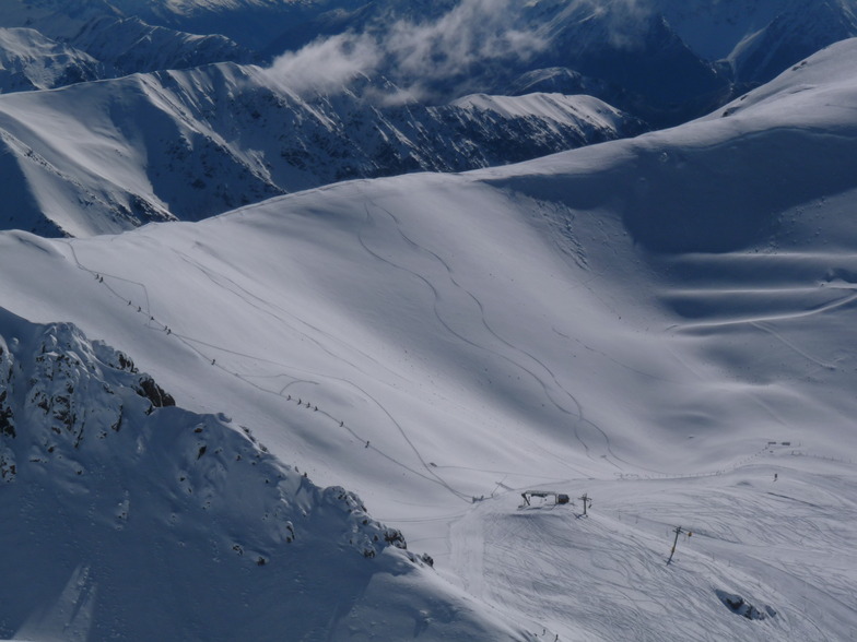
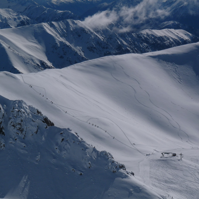
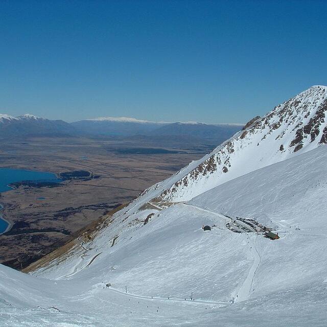
I just returned from an epic skiing adventure from Ohau 17/08/2008 - 20/08/2008. I agree with the previous reviews. This place packs a "wicked" punch and defiantly punches above it's weight for both terrain and atmosphere. First of all, the view from the ski field over lake Ohau has to be seen in person to be believed, and some photo's although look awesome, just are not as good as the real thing! The Staff on the Mountain and Ohau lodge are excellent, and in my mind should be retained. The day lodge up on the mountain makes an excellent coffee, and provides plenty of refreshment after all the walking up to Sutton’s peak. The groomed runs first thing in the morning are a great way to warm up the legs. What terrain in bounds not to mention all the Off Piste walking! Some in our group managed 800 vertical meters from the top of Sutton's to the digger on one of the bends in the road coming up the Mountain! Not bad for such a little ski field!!!! The Ohau Lodge at the base of the drive up to the ski area, was a beautiful place to stay, It had a rustic old world charm with modern day creature comforts, once again the hiring policy has to be recommended (Yay for the English Girls, very pleasant on the eyes indeed), the food was much better than I would of imagined and the rooms were very warm and comfortable. What a pleasure to wake up to some of the best views in the world!!!! I’m bringing my kids next time! One of New Zealand’s best kept secrets and I hope it stays that way!!!!
Chris Barnett from Australia writes:
I just returned from an epic skiing adventure from Ohau 17/08/2008 - 20/08/2008. I agree with the previous reviews. This place packs a "wicked" punch and defiantly punches above it's weight for both terrain and atmosphere. First of all, the view from the ski field over lake Ohau has to be seen in person to be believed, and some photo's although look awesome, just are not as good as the real thing! The Staff on the Mountain and Ohau lodge are excellent, and in my mind should be retained. The day lodge up on the mountain makes an excellent coffee, and provides plenty of refreshment after all the walking up to Sutton’s peak. The groomed runs first thing in the morning are a great way to warm up the legs. What terrain in bounds not to mention all the Off Piste walking! Some in our group managed 800 vertical meters from the top of Sutton's to the digger on one of the bends in the road coming up the Mountain! Not bad for such a little ski field!!!!
The Ohau Lodge at the base of the drive up to the ski area, was a beautiful place to stay, It had a rustic old world charm with modern day creature comforts, once again the hiring policy has to be recommended (Yay for the English Girls, very pleasant on the eyes indeed), the food was much better than I would of imagined and the rooms were very warm and comfortable. What a pleasure to wake up to some of the best views in the world!!!! I’m bringing my kids next time!
One of New Zealand’s best kept secrets and I hope it stays that way!!!!


 Nearest