

Global Weekly Snow Roundup #314
Weekly Global Snow News, updated 14 May 2026: Fresh snowfall in Argentina, Australia and Lesotho signals winter’s approach, while Japan maintains the world’s deepest snowpack.

Next 3 days weather summary:A moderate fall of snow, heaviest on Mon night. Temperatures will be below freezing (max -4°C on Mon afternoon, min -10°C on Sat morning). Wind will be generally light. | Days 4-6 weather summary:A dusting of new snow. Freeze-thaw conditions (max 3°C on Thu afternoon, min -4°C on Tue morning). Wind will be generally light. | |||||||||||||||||
Saturday 16 | Sunday 17 | Monday 18 | Tuesday 19 | Wednesday 20 | Thursday 21 | |||||||||||||
AM | PM | night | AM | PM | night | AM | PM | night | AM | PM | night | AM | PM | night | AM | PM | night | |
light snow | snow shwrs | snow shwrs | clear | light snow | light snow | light snow | light snow | mod. snow | some clouds | light snow | light snow | some clouds | snow shwrs | snow shwrs | clear | clear | clear | |
km/h | ||||||||||||||||||
Snow map |  |  |  |  |  |  | ||||||||||||
3 | 1 | — | — | — | — | 1 | 2 | 10 | — | — | — | — | — | — | — | — | — | |
— | — | — | — | — | — | — | — | — | — | — | — | — | — | — | — | — | — | |
max °C | -10 | -9 | -8 | -7 | -5 | -5 | -5 | -4 | -4 | -4 | -2 | -2 | -3 | -1 | 0 | -1 | 3 | 3 |
min °C | -10 | -9 | -9 | -7 | -6 | -6 | -6 | -4 | -5 | -4 | -3 | -3 | -3 | -2 | -1 | -1 | 2 | 2 |
-17 | -15 | -14 | -7 | -9 | -6 | -8 | -8 | -8 | -7 | -3 | -3 | -6 | -4 | -4 | -4 | 0 | 0 | |
88 | 87 | 64 | 68 | 84 | 91 | 89 | 89 | 94 | 76 | 79 | 96 | 83 | 81 | 73 | 84 | 62 | 37 | |
1750 | 2000 | 1300 | 2150 | 2450 | 2150 | 2350 | 2550 | 2150 | 2450 | 2750 | 2600 | 2750 | 3000 | 2950 | 3000 | 3450 | 3450 | |
5:39 | — | — | 5:39 | — | — | 5:37 | — | — | 5:37 | — | — | 5:35 | — | — | 5:35 | — | — | |
— | — | 8:44 | — | — | 8:45 | — | — | 8:46 | — | — | 8:47 | — | — | 8:49 | — | — | 8:50 | |
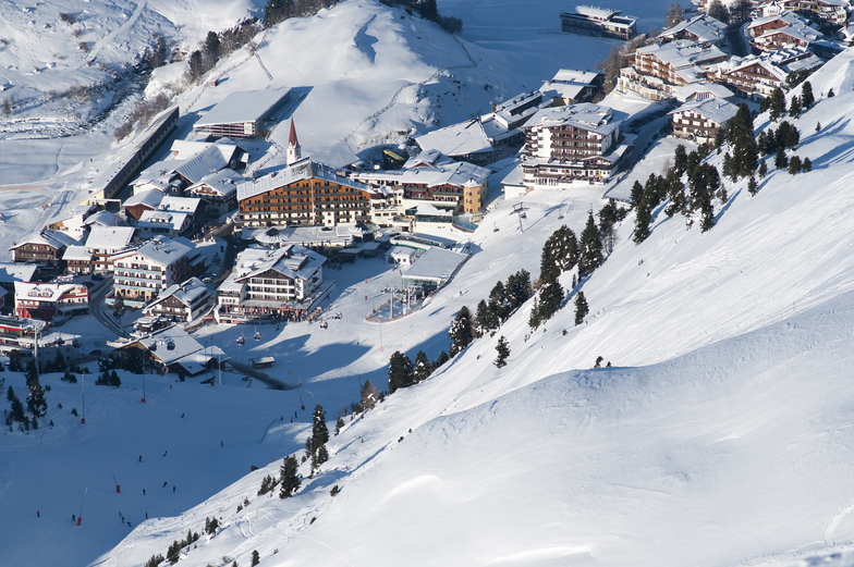
Latest snow reports near Obergurgl:
| Top snow depth: | 0 cm |
|---|---|
| Bottom snow depth: | 0 cm |
| Fresh snowfall depth: | 46 cm |
| Last snowfall: | 15 May 2026 |
| Snow Alerts | Create Alert |
0.4 | Bluebird Powder days Fresh snow, mostly sunny, light wind. |
|---|---|
2.1 | Powder days Fresh snow, limited sun, any wind. |
0.8 | Bluebird days Average snow, mostly sunny, light wind. |
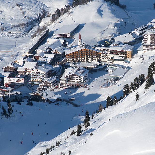
The above table gives the weather forecast for Obergurgl at the specific elevation of 3080 m. Our sophisticated weather models allow us to provide snow forecasts for the top, middle and bottom ski stations of Obergurgl. To access the weather forecasts for the other elevations, use the tab navigation above the table. For a wider view of the weather, check out the Weather Map of Austria.
Click here to read further information on freezing levels and how we forecast our temperatures.
Overall 4.0 Based on 47 votes and 47 reviews
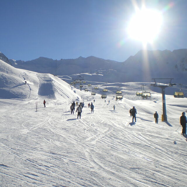
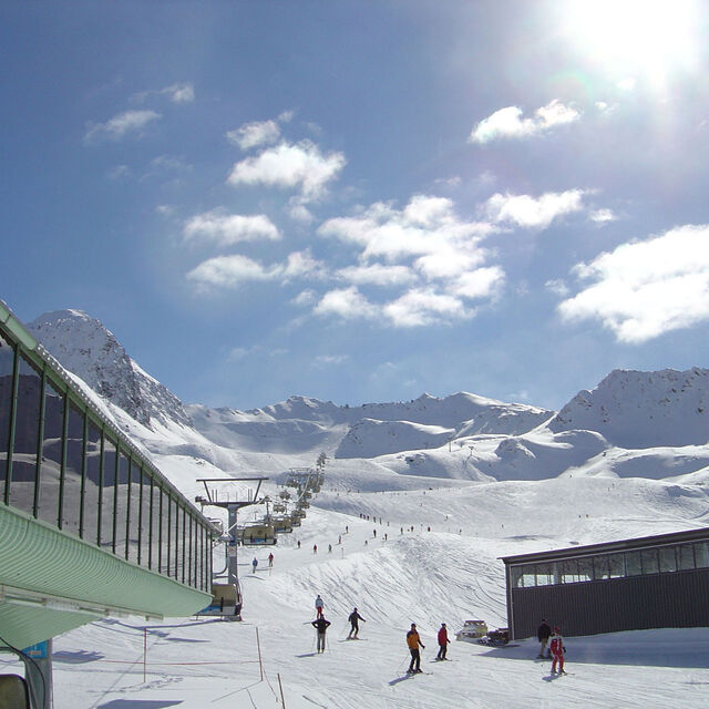
Just returned from a week in Obergurgl staying at Haus Verwall Apartments. Accommodation was excellent, clean, modern, great breakfasts, wonderful host and right by ski school and bottom lifts. Would recommend this accommodation to anybody with a number of restaurants and takeaways within a few minutes walk. Weather was excellent, blue skies, no wind and the slopes well groomed. Temperatures slightly higher than normal so best skiing in the morning leaving the afternoons for playing in the sun. Nederhutte can't be beaten for apres-ski and you can still ski down to the town or ride on a skidoo if you've overdone the partying. Overall, a good family oriented resort with a good mix of runs for all abilities. If you run out of pistes to explore there is a free bus service to Solden and the lift pass covers it all. Great time was had by all from age 4 to 62.
TonyS from United Kingdom writes:
Just returned from a week in Obergurgl staying at Haus Verwall Apartments. Accommodation was excellent, clean, modern, great breakfasts, wonderful host and right by ski school and bottom lifts. Would recommend this accommodation to anybody with a number of restaurants and takeaways within a few minutes walk. Weather was excellent, blue skies, no wind and the slopes well groomed. Temperatures slightly higher than normal so best skiing in the morning leaving the afternoons for playing in the sun. Nederhutte can't be beaten for apres-ski and you can still ski down to the town or ride on a skidoo if you've overdone the partying. Overall, a good family oriented resort with a good mix of runs for all abilities. If you run out of pistes to explore there is a free bus service to Solden and the lift pass covers it all. Great time was had by all from age 4 to 62.


 Nearest