

Global Weekly Snow Roundup #318
Weekly Snow News for the world, updated 11 June 2026: Australia's season begins, Val d’Isère reopens and major snowfall is forecast for the Andes.

Next 3 days weather summary:Light rain (total 2.0mm), mostly falling on Thu afternoon. Warm (max 21°C on Sun morning, min 6°C on Thu night). Wind will be generally light. | Days 4-6 weather summary:Mostly dry. Warm (max 23°C on Sun afternoon, min 7°C on Tue night). Wind will be generally light. | ||||||||||||||||
Thu 11 | Friday 12 | Saturday 13 | Sunday 14 | Monday 15 | Tuesday 16 | ||||||||||||
PM | night | AM | PM | night | AM | PM | night | AM | PM | night | AM | PM | night | AM | PM | night | |
light rain | rain shwrs | some clouds | clear | clear | clear | some clouds | some clouds | clear | some clouds | some clouds | cloudy | cloudy | some clouds | some clouds | some clouds | some clouds | |
km/h | |||||||||||||||||
Snow map | 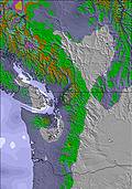 | 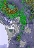 | 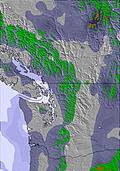 | 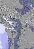 | 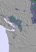 | 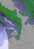 | |||||||||||
— | — | — | — | — | — | — | — | — | — | — | — | — | — | — | — | — | |
1 | 1 | — | — | — | — | — | — | — | — | — | — | — | — | — | — | — | |
max °C | 11 | 9 | 12 | 16 | 14 | 18 | 20 | 18 | 21 | 23 | 20 | 19 | 17 | 15 | 14 | 15 | 11 |
min °C | 10 | 6 | 9 | 15 | 10 | 14 | 20 | 14 | 18 | 23 | 16 | 17 | 16 | 9 | 11 | 14 | 7 |
10 | 5 | 8 | 15 | 10 | 14 | 20 | 14 | 18 | 23 | 16 | 17 | 16 | 9 | 11 | 14 | 7 | |
76 | 78 | 56 | 37 | 43 | 39 | 39 | 39 | 37 | 43 | 56 | 51 | 54 | 76 | 74 | 75 | 93 | |
2450 | 2900 | 3000 | 3200 | 3700 | 3850 | 3950 | 4250 | 4250 | 4400 | 4500 | 4150 | 3900 | 3700 | 3400 | 2950 | 2700 | |
— | — | 5:13 | — | — | 5:13 | — | — | 5:11 | — | — | 5:11 | — | — | 5:11 | — | — | |
— | 9:28 | — | — | 9:29 | — | — | 9:29 | — | — | 9:30 | — | — | 9:30 | — | — | 9:30 | |
Go pro and carve into:
Avalanche information: Avalanche Canada
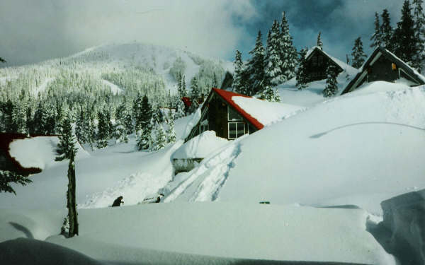
Latest snow reports near Mount Washington:
| Top snow depth: | — |
|---|---|
| Bottom snow depth: | — |
| Fresh snowfall depth: | — |
| Last snowfall: | 8 Jun 2026 |
| Snow Alerts | Create Alert |
0.0 | Bluebird Powder days Fresh snow, mostly sunny, light wind. |
|---|---|
0.0 | Powder days Fresh snow, limited sun, any wind. |
0.0 | Bluebird days Average snow, mostly sunny, light wind. |
The above table gives the weather forecast for Mount Washington at the specific elevation of 1084 m. Our sophisticated weather models allow us to provide snow forecasts for the top, middle and bottom ski stations of Mount Washington. To access the weather forecasts for the other elevations, use the tab navigation above the table. For a wider view of the weather, check out the Weather Map of Canada.
Click here to read further information on freezing levels and how we forecast our temperatures.
Overall 3.2 Based on 220 votes and 377 reviews
The grooming has gotten a lot better after they re built the grooming team. The last grooming leader was terrible. Treated crew like garbage. Nice to see the resort get some new red on the slopes. And finally the grooming of powder face. Well done team. Glad to see some fresh ideas!
Westcoast from Canada writes:
The grooming has gotten a lot better after they re built the grooming team. The last grooming leader was terrible. Treated crew like garbage. Nice to see the resort get some new red on the slopes. And finally the grooming of powder face. Well done team. Glad to see some fresh ideas!
Read 376 more reviews of Mount Washington or submit your own


 Nearest