

Global Weekly Snow Roundup #314
Weekly Global Snow News, updated 14 May 2026: Fresh snowfall in Argentina, Australia and Lesotho signals winter’s approach, while Japan maintains the world’s deepest snowpack.

Next 3 days weather summary:A light fall of snow, heaviest on Fri afternoon. Turning milder with light rain (total 5.0mm) on Sat afternoon. Freeze-thaw conditions (max 7°C on Sun afternoon, min -2°C on Fri night). Wind will be generally light. | Days 4-6 weather summary:Moderate rain (total 14.0mm), heaviest on Mon morning. Mild temperatures (max 9°C on Wed afternoon, min 3°C on Mon night). Wind will be generally light. | |||||||||||||||||
Friday 15 | Saturday 16 | Sunday 17 | Monday 18 | Tuesday 19 | Wednesday 20 | |||||||||||||
AM | PM | night | AM | PM | night | AM | PM | night | AM | PM | night | AM | PM | night | AM | PM | night | |
light snow | mod. snow | light snow | light snow | light snow | light snow | some clouds | light rain | light rain | light rain | light rain | rain shwrs | rain shwrs | light rain | rain shwrs | some clouds | light rain | light rain | |
km/h | ||||||||||||||||||
Snow map | 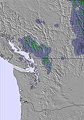 | 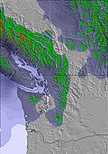 | 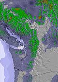 | 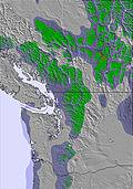 | 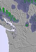 | 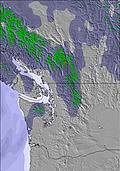 | ||||||||||||
2 | 6 | 2 | 2 | — | — | — | — | — | — | — | — | — | — | — | — | — | — | |
— | — | — | — | 2 | 1 | — | 1 | 1 | 1 | 2 | 3 | 2 | 2 | 1 | — | 2 | 1 | |
max °C | 1 | 1 | 1 | 1 | 3 | 2 | 4 | 7 | 5 | 6 | 8 | 5 | 6 | 8 | 6 | 8 | 9 | 8 |
min °C | 1 | 1 | -2 | 0 | 2 | -1 | 2 | 5 | 2 | 4 | 7 | 3 | 5 | 7 | 3 | 6 | 9 | 5 |
-1 | -2 | -4 | -2 | 0 | -1 | 1 | 5 | 2 | 4 | 6 | 3 | 5 | 6 | 3 | 6 | 9 | 5 | |
99 | 99 | 97 | 97 | 89 | 96 | 92 | 87 | 91 | 89 | 58 | 95 | 88 | 79 | 74 | 79 | 80 | 76 | |
1200 | 1200 | 1050 | 1200 | 1400 | 1250 | 1500 | 2050 | 1850 | 1850 | 2000 | 1750 | 1900 | 2150 | 2100 | 2300 | 2400 | 3100 | |
5:26 | — | — | 5:24 | — | — | 5:22 | — | — | 5:22 | — | — | 5:20 | — | — | 5:18 | — | — | |
— | — | 8:40 | — | — | 8:43 | — | — | 8:44 | — | — | 8:45 | — | — | 8:46 | — | — | 8:47 | |
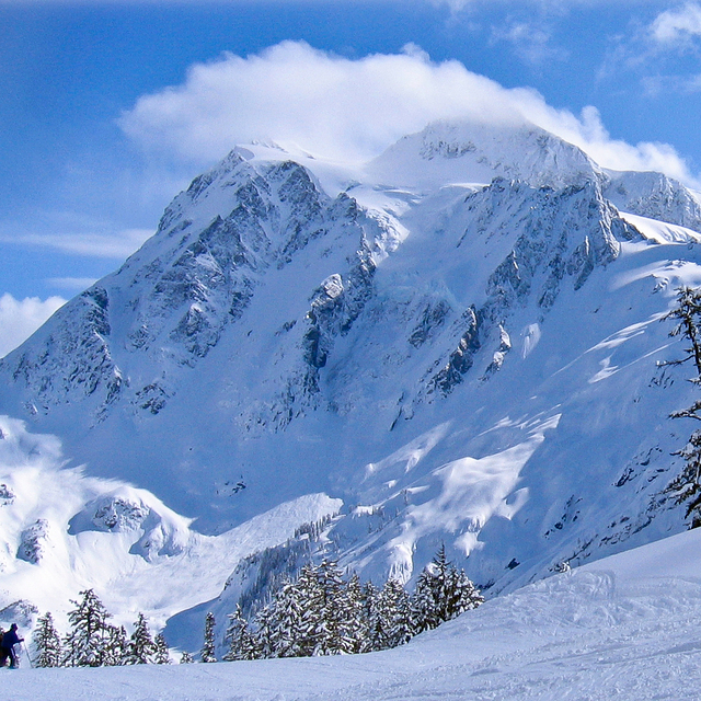
Latest snow reports near Mount Baker:
| Top snow depth: | — |
|---|---|
| Bottom snow depth: | — |
| Fresh snowfall depth: | 10 cm |
| Last snowfall: | 14 May 2026 |
| Snow Alerts | Create Alert |
0.0 | Bluebird Powder days Fresh snow, mostly sunny, light wind. |
|---|---|
0.0 | Powder days Fresh snow, limited sun, any wind. |
0.0 | Bluebird days Average snow, mostly sunny, light wind. |
The above table gives the weather forecast for Mount Baker at the specific elevation of 1067 m. Our sophisticated weather models allow us to provide snow forecasts for the top, middle and bottom ski stations of Mount Baker. To access the weather forecasts for the other elevations, use the tab navigation above the table. For a wider view of the weather, check out the Weather Map of United States.
Click here to read further information on freezing levels and how we forecast our temperatures.
Overall 2.7 Based on 101 votes and 80 reviews
Baker is... Baker. There's nothing like it. That's good, and not so good. But you don't come here for the glitzy, corporate, mani-pedi, $20 apres drink, packed like sardines gondola, sleep in your king-sized goose down comforter bed. You come here to shred, without all the B.S. I've skied all over N. America and Europe for 50 years, and for me, Baker is heaven. Sure, Alta has better snow. Sure, Whistler has a cool village. But they also cost you $2,000 for a weekend and you're surrounded by thousands and thousands of people, Not all of whom you really want to mingle with. Yeah, I've made the (short) drive only to find rain and sleet. But I've also skied untouched powder out of bounds (legally) with not a soul around. That's winter sports. Mother nature is fickle, so deal with it. Some days you win, some days you lose. But it's always real.
KBinPNW from United States writes:
Baker is... Baker. There's nothing like it. That's good, and not so good. But you don't come here for the glitzy, corporate, mani-pedi, $20 apres drink, packed like sardines gondola, sleep in your king-sized goose down comforter bed. You come here to shred, without all the B.S. I've skied all over N. America and Europe for 50 years, and for me, Baker is heaven. Sure, Alta has better snow. Sure, Whistler has a cool village. But they also cost you $2,000 for a weekend and you're surrounded by thousands and thousands of people, Not all of whom you really want to mingle with. Yeah, I've made the (short) drive only to find rain and sleet. But I've also skied untouched powder out of bounds (legally) with not a soul around. That's winter sports. Mother nature is fickle, so deal with it. Some days you win, some days you lose. But it's always real.


 Nearest