

Global Weekly Snow Roundup #314
Weekly Global Snow News, updated 14 May 2026: Fresh snowfall in Argentina, Australia and Lesotho signals winter’s approach, while Japan maintains the world’s deepest snowpack.

Next 4 days weather summary:Light rain (total 6.0mm), mostly falling on Sat night. Freeze-thaw conditions (max 6°C on Sat afternoon, min -2°C on Fri night). Wind will be generally light. | Days 5-7 weather summary:Light rain (total 8.0mm), mostly falling on Tue morning. Very mild (max 12°C on Thu morning, min 3°C on Mon night). Winds increasing (light winds from the ESE on Tue afternoon, fresh winds from the W by Wed morning). | |||||||||||||||
Saturday 16 | Sunday 17 | Monday 18 | Tuesday 19 | Wednesday 20 | ||||||||||||
night | AM | PM | night | AM | PM | night | AM | PM | night | AM | PM | night | AM | PM | night | |
snow shwrs | cloudy | cloudy | light snow | rain shwrs | rain shwrs | some clouds | cloudy | light rain | some clouds | light rain | light rain | rain shwrs | clear | some clouds | rain shwrs | |
km/h | ||||||||||||||||
Snow map |  |  |  |  | 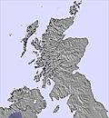 |  | ||||||||||
— | — | — | — | — | — | — | — | — | — | — | — | — | — | — | — | |
— | — | — | 1 | 1 | 2 | — | — | 2 | — | 2 | 1 | 2 | — | — | 1 | |
max °C | 0 | 4 | 6 | 3 | 5 | 5 | 3 | 5 | 6 | 4 | 4 | 5 | 5 | 7 | 8 | 8 |
min °C | -2 | 1 | 3 | 2 | 3 | 5 | 2 | 4 | 5 | 3 | 4 | 5 | 4 | 6 | 8 | 6 |
-7 | -2 | 0 | -2 | -1 | 1 | -2 | 2 | 1 | -1 | -1 | 3 | -1 | 1 | 4 | 3 | |
92 | 73 | 47 | 97 | 78 | 69 | 83 | 78 | 71 | 89 | 89 | 98 | 97 | 67 | 53 | 78 | |
600 | 900 | 1500 | 1100 | 1200 | 1350 | 1300 | 1300 | 1500 | 1450 | 1400 | 1750 | 1800 | 1450 | 1850 | 2100 | |
— | 4:52 | — | — | 4:50 | — | — | 4:48 | — | — | 4:47 | — | — | 4:45 | — | — | |
— | — | 9:27 | — | — | 9:29 | — | — | 9:30 | — | — | 9:32 | — | — | 9:35 | — | |
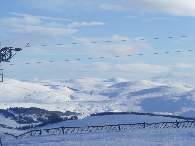
Latest snow reports near The Lecht:
| Top snow depth: | — |
|---|---|
| Bottom snow depth: | — |
| Fresh snowfall depth: | 6 cm |
| Last snowfall: | 14 May 2026 |
| Snow Alerts | Create Alert |
0.0 | Bluebird Powder days Fresh snow, mostly sunny, light wind. |
|---|---|
0.4 | Powder days Fresh snow, limited sun, any wind. |
0.0 | Bluebird days Average snow, mostly sunny, light wind. |


The above table gives the weather forecast for The Lecht at the specific elevation of 823 m. Our sophisticated weather models allow us to provide snow forecasts for the top, middle and bottom ski stations of The Lecht. To access the weather forecasts for the other elevations, use the tab navigation above the table. For a wider view of the weather, check out the Weather Map of United Kingdom.
Click here to read further information on freezing levels and how we forecast our temperatures.
Overall 2.5 Based on 19 votes and 18 reviews
Been to the Lecht many times and always had a hoot. The owners are a lovely family; very friendly and helpful. Thankfully it is still family owned so they are not just in the game to make fast cash, unlike natural retreats aka 'the gorm'. A much smaller resort than 'the gorm', but cheaper and not as busy which means more runs and is also hidden from the wind that closed Cairngorm every other day. Best food in any resort in Scotland; well priced unlike the robbing fools at Cairngorm who are only interested in profits. Being over 1000ft below 'the gorm' height, they do suffer from lack of snow at times and have to make do with what they get.
RyanM from United Kingdom writes:
Been to the Lecht many times and always had a hoot.
The owners are a lovely family; very friendly and helpful.
Thankfully it is still family owned so they are not just in the game to make fast cash, unlike natural retreats aka 'the gorm'.
A much smaller resort than 'the gorm', but cheaper and not as busy which means more runs and is also hidden from the wind that closed Cairngorm every other day.
Best food in any resort in Scotland; well priced unlike the robbing fools at Cairngorm who are only interested in profits.
Being over 1000ft below 'the gorm' height, they do suffer from lack of snow at times and have to make do with what they get.


 Nearest