

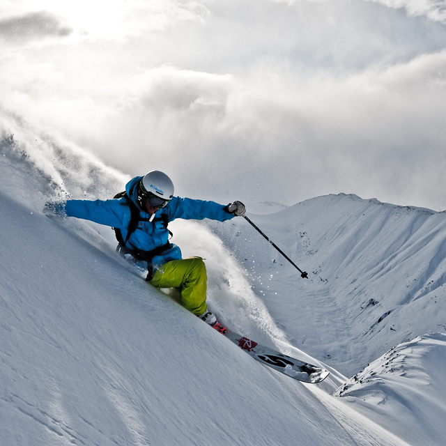
Portillo Re-Opens To Guests Arriving By Helicopter
Chile’s famous Portillo ski resort is reported to have re-opened to guests arriving by helicopter after being cut off by road for more than two weeks by over 6m/20 feet of snowfall.

Next 4 days weather summary:Mostly dry. Mild temperatures (max 8°C on Tue morning, min 2°C on Sun night). Wind will be generally light. | Days 5-7 weather summary:Light rain (total 6.0mm), mostly falling on Fri afternoon. Mild temperatures (max 6°C on Wed night, min 2°C on Fri night). Wind will be generally light. | |||||||||||||||
Monday 3 | Tuesday 4 | Wednesday 5 | Thursday 6 | Friday 7 | ||||||||||||
night | AM | PM | night | AM | PM | night | AM | PM | night | AM | PM | night | AM | PM | night | |
clear | clear | some clouds | clear | some clouds | clear | clear | clear | clear | clear | clear | some clouds | some clouds | rain shwrs | rain shwrs | cloudy | |
km/h | ||||||||||||||||
Snow map | 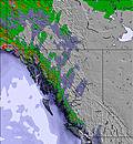 | 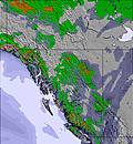 | 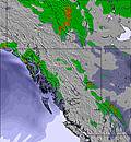 | 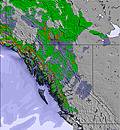 | 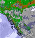 | 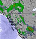 | ||||||||||
— | — | — | — | — | — | — | — | — | — | — | — | — | — | — | — | |
mm | — | — | — | — | — | — | — | — | — | — | — | — | — | 1 | 3 | — |
max °C | 2 | 4 | 5 | 6 | 8 | 8 | 7 | 7 | 7 | 6 | 5 | 6 | 5 | 5 | 4 | 3 |
min °C | 2 | 2 | 5 | 5 | 6 | 8 | 5 | 6 | 7 | 4 | 5 | 5 | 3 | 4 | 4 | 2 |
chill °C | 0 | 1 | 2 | 3 | 5 | 7 | 3 | 4 | 6 | 4 | 4 | 5 | 3 | 4 | 3 | 1 |
Humid % | 81 | 71 | 50 | 39 | 35 | 28 | 40 | 37 | 32 | 42 | 48 | 77 | 76 | 82 | 82 | 96 |
Freeze m | 2950 | 3050 | 3400 | 3900 | 4050 | 4100 | 4050 | 3900 | 3700 | 3550 | 3450 | 3250 | 3300 | 3200 | 3250 | 3100 |
— | 4:41 | — | — | 4:43 | — | — | 4:46 | — | — | 4:48 | — | — | 4:50 | — | — | |
— | — | 8:45 | — | — | 8:44 | — | — | 8:42 | — | — | 8:39 | — | — | 8:37 | — | |
Go pro and carve into:
Avalanche information: Avalanche Canada
Latest snow reports near Last Frontier Heliskiing:
| Top snow depth: | — |
|---|---|
| Bottom snow depth: | — |
| Fresh snowfall depth: | — |
| Last snowfall: | 9 Jul 2026 |
| Snow Alerts | Create Alert |
0.1 | Bluebird Powder days Fresh snow, mostly sunny, light wind. |
|---|---|
0.3 | Powder days Fresh snow, limited sun, any wind. |
0.2 | Bluebird days Average snow, mostly sunny, light wind. |
The above table gives the weather forecast for Last Frontier Heliskiing at the specific elevation of 2599 m. Our sophisticated weather models allow us to provide snow forecasts for the top, middle and bottom ski stations of Last Frontier Heliskiing. To access the weather forecasts for the other elevations, use the tab navigation above the table. For a wider view of the weather, check out the Weather Map of Canada.
Click here to read further information on freezing levels and how we forecast our temperatures.


 Nearest