

Global Weekly Snow Roundup #314
Weekly Global Snow News, updated 14 May 2026: Fresh snowfall in Argentina, Australia and Lesotho signals winter’s approach, while Japan maintains the world’s deepest snowpack.

Next 3 days weather summary:Moderate rain (total 10.0mm), heaviest on Sun afternoon. Freeze-thaw conditions (max 6°C on Mon afternoon, min -3°C on Sat morning). Wind will be generally light. | Days 4-6 weather summary:Light rain (total 3.0mm), mostly falling on Tue afternoon. Very mild (max 16°C on Thu afternoon, min 5°C on Tue morning). Wind will be generally light. | |||||||||||||||||
Saturday 16 | Sunday 17 | Monday 18 | Tuesday 19 | Wednesday 20 | Thursday 21 | |||||||||||||
AM | PM | night | AM | PM | night | AM | PM | night | AM | PM | night | AM | PM | night | AM | PM | night | |
clear | some clouds | cloudy | some clouds | light rain | snow shwrs | light rain | light rain | light rain | some clouds | light rain | rain shwrs | clear | some clouds | rain shwrs | clear | clear | clear | |
km/h | ||||||||||||||||||
Snow map |  |  |  |  |  |  | ||||||||||||
— | — | — | — | — | — | — | — | — | — | — | — | — | — | — | — | — | — | |
— | — | — | — | 3 | 3 | 1 | 2 | 1 | — | 1 | 1 | — | — | 1 | — | — | — | |
max °C | 0 | 4 | 3 | 3 | 3 | 3 | 4 | 6 | 6 | 6 | 8 | 8 | 10 | 13 | 12 | 14 | 16 | 15 |
min °C | -3 | 3 | 1 | 1 | 3 | 1 | 2 | 5 | 4 | 5 | 8 | 7 | 7 | 12 | 10 | 11 | 15 | 12 |
-8 | 0 | 1 | 1 | 3 | -1 | 0 | 3 | 2 | 3 | 8 | 7 | 7 | 12 | 10 | 11 | 15 | 12 | |
69 | 67 | 87 | 74 | 86 | 84 | 76 | 77 | 69 | 75 | 76 | 80 | 53 | 64 | 57 | 37 | 49 | 57 | |
2100 | 2600 | 2300 | 2400 | 2500 | 2350 | 2600 | 2750 | 2800 | 3000 | 3100 | 3200 | 3550 | 3700 | 3950 | 4100 | 4000 | 3950 | |
6:35 | — | — | 6:33 | — | — | 6:33 | — | — | 6:31 | — | — | 6:31 | — | — | 6:30 | — | — | |
— | — | 9:13 | — | — | 9:14 | — | — | 9:15 | — | — | 9:15 | — | — | 9:16 | — | — | 9:17 | |
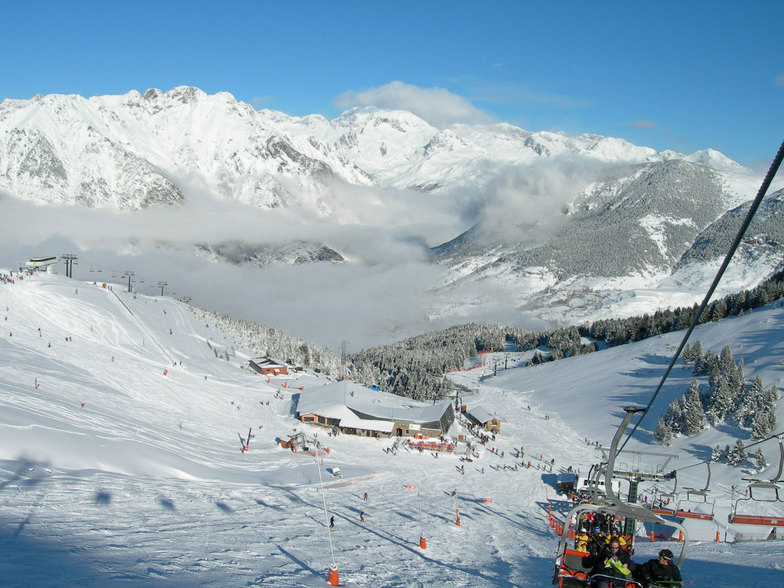
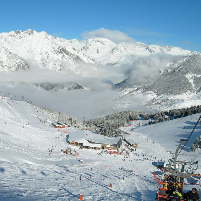
Latest snow reports near Cerler:
| Top snow depth: | — |
|---|---|
| Bottom snow depth: | — |
| Fresh snowfall depth: | 3 cm |
| Last snowfall: | 15 May 2026 |
| Snow Alerts | Create Alert |
0.1 | Bluebird Powder days Fresh snow, mostly sunny, light wind. |
|---|---|
0.1 | Powder days Fresh snow, limited sun, any wind. |
0.0 | Bluebird days Average snow, mostly sunny, light wind. |
The above table gives the weather forecast for Cerler at the specific elevation of 2070 m. Our sophisticated weather models allow us to provide snow forecasts for the top, middle and bottom ski stations of Cerler. To access the weather forecasts for the other elevations, use the tab navigation above the table. For a wider view of the weather, check out the Weather Map of Spain.
Click here to read further information on freezing levels and how we forecast our temperatures.
Overall 4.0 Based on 61 votes and 28 reviews
Just came back from a fantastic weekend at Cerler. I have been meaning to visit the resort, but being tucked nicely deep in the Pyrenees,it is further away than Formigal from Madrid. The resort might look small compared to its bigger siblings, but what Cerler lacks in size, it makes up for the variety of terrain and pistes. The central lift takes you get from 1500 to 2000 mts and from there you can easily access to a couple of mountains that lead back to the 2000 hub or jump to the other sector of Ampriu. Cerler's side is nicely covered with trees and with good snow it's a delight to go off-piste and navigate between the forest. The reds on western most side of the Cielo lift, are good fun while the reds and blacks on the Sarrau lift's side offer a nice challenge. The Ampriu sector has a more traditional bowl arrangement, but is nevertheless as fun as the Cerler sector. With wide red and blues, and some fine off-piste when conditions are ripe, Ampriu offers a good challenge. Its setup is more efficient than Cerler as the central hub makes it faster to reach the different mountains in the bowl. Lifts are also newer and faster than in the Cerler side. Pico de Gallinero is a highlight, as the highest point and with a great drop of between 500-700 mts, it offers a variety of runs for intermediates and advanced skiers. Visibility can be an issue given its exposure, but even with strong gusts of wind like the ones we faced, we could find our way to the bottom of the valley. The new sector, Castaneda, looks fun, however, when we were there the wind and visibility made it difficult to truly enjoy the run. On the other side, the Basibe runs that lead back to Ampriu, are good fun with some great off piste on the sides when there's no considerable avalanche risk. Lastly, Cerler excels where other Pyreneean resorts don't in well groomed long runs. I found that Baqueira, Formigal and to some extent Grandvalira (though have to revisit as when I was there the home runs were all closed due to lack of snow) where good resorts, but with shorter, less playful runs. The famous 9KM run from the top of Gallinero to Cerler's bottom hub is good fun. I skied it down with my son and it took us around 30 mins at a moderate pace and doing side off-piste quests. We ended up clocking 6.7 kms as we took some shorter reds, and even if the full 9kms run short if you do the "proper" itinerary, you'll still have a blast given the diversity of its terrain- drops, tree navigating, cruisy blues, moguly reds, etc. The restaurants on offer are great, on-mountain there's 4 restaurants, and down in the village plenty more. Most people use Benasque as their base, which is considered the Pyrenees Chamonix for a good reason: there's some serious mountaineering going on year round. Skiing is just one of the many activities around Pico Aneto, the tallest mountain in the Pyrenees. I thoroughly enjoyed Cerler given that we had between 120-220 cms of snow. As a mid sized resort, you'd think it would get repetitive fast, but in my experience, the playful terrain, opens up more possibilities than bigger resorts. I would compare it to Les Contamines, in France. Nice hidden gem that locals enjoy and who probably don't want it to be too well known. :)
Alex from Spain writes:
Just came back from a fantastic weekend at Cerler. I have been meaning to visit the resort, but being tucked nicely deep in the Pyrenees,it is further away than Formigal from Madrid.
The resort might look small compared to its bigger siblings, but what Cerler lacks in size, it makes up for the variety of terrain and pistes. The central lift takes you get from 1500 to 2000 mts and from there you can easily access to a couple of mountains that lead back to the 2000 hub or jump to the other sector of Ampriu.
Cerler's side is nicely covered with trees and with good snow it's a delight to go off-piste and navigate between the forest. The reds on western most side of the Cielo lift, are good fun while the reds and blacks on the Sarrau lift's side offer a nice challenge.
The Ampriu sector has a more traditional bowl arrangement, but is nevertheless as fun as the Cerler sector. With wide red and blues, and some fine off-piste when conditions are ripe, Ampriu offers a good challenge. Its setup is more efficient than Cerler as the central hub makes it faster to reach the different mountains in the bowl. Lifts are also newer and faster than in the Cerler side.
Pico de Gallinero is a highlight, as the highest point and with a great drop of between 500-700 mts, it offers a variety of runs for intermediates and advanced skiers. Visibility can be an issue given its exposure, but even with strong gusts of wind like the ones we faced, we could find our way to the bottom of the valley.
The new sector, Castaneda, looks fun, however, when we were there the wind and visibility made it difficult to truly enjoy the run. On the other side, the Basibe runs that lead back to Ampriu, are good fun with some great off piste on the sides when there's no considerable avalanche risk.
Lastly, Cerler excels where other Pyreneean resorts don't in well groomed long runs. I found that Baqueira, Formigal and to some extent Grandvalira (though have to revisit as when I was there the home runs were all closed due to lack of snow) where good resorts, but with shorter, less playful runs.
The famous 9KM run from the top of Gallinero to Cerler's bottom hub is good fun. I skied it down with my son and it took us around 30 mins at a moderate pace and doing side off-piste quests. We ended up clocking 6.7 kms as we took some shorter reds, and even if the full 9kms run short if you do the "proper" itinerary, you'll still have a blast given the diversity of its terrain- drops, tree navigating, cruisy blues, moguly reds, etc.
The restaurants on offer are great, on-mountain there's 4 restaurants, and down in the village plenty more. Most people use Benasque as their base, which is considered the Pyrenees Chamonix for a good reason: there's some serious mountaineering going on year round. Skiing is just one of the many activities around Pico Aneto, the tallest mountain in the Pyrenees.
I thoroughly enjoyed Cerler given that we had between 120-220 cms of snow. As a mid sized resort, you'd think it would get repetitive fast, but in my experience, the playful terrain, opens up more possibilities than bigger resorts.
I would compare it to Les Contamines, in France. Nice hidden gem that locals enjoy and who probably don't want it to be too well known. :)


 Nearest