

Global Weekly Snow Roundup #314
Weekly Global Snow News, updated 14 May 2026: Fresh snowfall in Argentina, Australia and Lesotho signals winter’s approach, while Japan maintains the world’s deepest snowpack.

Next 3 days weather summary:Light rain (total 4.0mm), mostly falling on Sun morning. Mild temperatures (max 8°C on Sat afternoon, min 4°C on Mon night). Winds decreasing (near gales from the NNW on Sat night, light winds from the NW by Sun night). | Days 4-6 weather summary:Mostly dry. Mild temperatures (max 5°C on Thu night, min 1°C on Wed morning). Winds increasing (calm on Tue night, fresh winds from the SW by Thu night). | ||||||||||||||||
Sat 16 | Sunday 17 | Monday 18 | Tuesday 19 | Wednesday 20 | Thursday 21 | ||||||||||||
PM | night | AM | PM | night | AM | PM | night | AM | PM | night | AM | PM | night | AM | PM | night | |
some clouds | some clouds | light rain | light rain | light rain | some clouds | clear | clear | clear | some clouds | some clouds | clear | clear | clear | some clouds | some clouds | clear | |
km/h | |||||||||||||||||
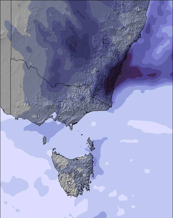
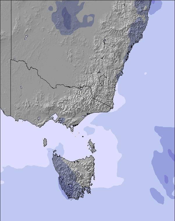
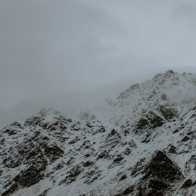
Snow map | 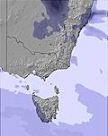 | 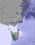 | 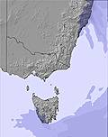 | 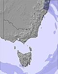 | 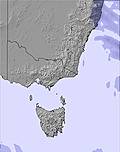 | 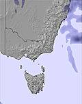 | |||||||||||
— | — | — | — | — | — | — | — | — | — | — | — | — | — | — | — | — | |
— | — | 1 | 2 | 1 | — | — | — | — | — | — | — | — | — | — | — | — | |
max °C | 8 | 8 | 6 | 7 | 6 | 6 | 6 | 5 | 5 | 4 | 3 | 1 | 2 | 4 | 4 | 3 | 5 |
min °C | 7 | 8 | 6 | 6 | 5 | 6 | 6 | 4 | 4 | 4 | 2 | 1 | 2 | 2 | 3 | 3 | 4 |
2 | 3 | 0 | 1 | 4 | 4 | 4 | -1 | 0 | 2 | -1 | -5 | -3 | -3 | -1 | -1 | -1 | |
68 | 57 | 92 | 98 | 99 | 73 | 60 | 76 | 70 | 84 | 73 | 71 | 75 | 49 | 57 | 79 | 72 | |
3000 | 3050 | 2750 | 2650 | 2600 | 2650 | 2600 | 2400 | 2400 | 2350 | 2200 | 2000 | 2500 | 2600 | 2650 | 2450 | 2400 | |
— | — | 7:11 | — | — | 7:11 | — | — | 7:13 | — | — | 7:13 | — | — | 7:15 | — | — | |
4:59 | — | — | 4:58 | — | — | 4:57 | — | — | 4:55 | — | — | 4:54 | — | — | 4:54 | — | |
Latest snow reports near Ben Lomond:
| Top snow depth: | — |
|---|---|
| Bottom snow depth: | — |
| Fresh snowfall depth: | — |
| Last snowfall: | 6 May 2026 |
| Snow Alerts | Create Alert |
0.1 | Bluebird Powder days Fresh snow, mostly sunny, light wind. |
|---|---|
0.2 | Powder days Fresh snow, limited sun, any wind. |
0.2 | Bluebird days Average snow, mostly sunny, light wind. |

The above table gives the weather forecast for Ben Lomond at the specific elevation of 1573 m. Our sophisticated weather models allow us to provide snow forecasts for the top, middle and bottom ski stations of Ben Lomond. To access the weather forecasts for the other elevations, use the tab navigation above the table. For a wider view of the weather, check out the Weather Map of Australia.
Click here to read further information on freezing levels and how we forecast our temperatures.
Overall 2.9 Based on 10 votes and 3 reviews
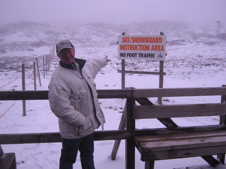
Ben Lomond is the largest of the two fields in Tasmania. It has some 8 tows covering the mountain which is an easy 1 hr drive from Launceston. It is a small field that focuses on fun...cheap lift tickets and easy access to the runs, which make Ben a favorite among locals, and a playground for the states north. It has one resort on mountain offering accomodation and a number or private lodges. There is a bar and restaurant and changing facilities, but the drive up is steep and winding, so check the forecast before you head up, and throw in some chains!!
Nick Russill from United Kingdom writes:
Ben Lomond is the largest of the two fields in Tasmania. It has some 8 tows covering the mountain which is an easy 1 hr drive from Launceston.
It is a small field that focuses on fun...cheap lift tickets and easy access to the runs, which make Ben a favorite among locals, and a playground for the states north. It has one resort on mountain offering accomodation and a number or private lodges. There is a bar and restaurant and changing facilities, but the drive up is steep and winding, so check the forecast before you head up, and throw in some chains!!


 Nearest