


View forecast
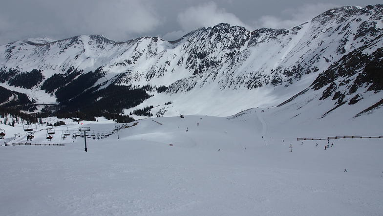
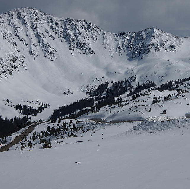
Arapahoe Basin at 3286 m altitude
Issued by Snow-Forecast.com at: 11 am (local time) / 19 May 2024
Now
Sunday 19 | Monday 20 | Tuesday 21 | Wednesday 22 | Thursday 23 | Friday 24 | Saturday 25 | |||||||||||||||
AM | PM | night | AM | PM | night | AM | PM | night | AM | PM | night | AM | PM | night | AM | PM | night | AM | PM | night | |
some clouds | risk thun- der | rain shwrs | clear | cloudy | some clouds | rain shwrs | light snow | snow shwrs | some clouds | cloudy | clear | clear | rain shwrs | snow shwrs | clear | some clouds | some clouds | some clouds | light rain | rain shwrs | |
km/h | |||||||||||||||||||||
Snow map |  |  |  |  |  | 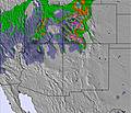 | 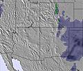 | ||||||||||||||
— | — | — | — | — | — | — | 1.0 | 1.0 | — | — | — | — | — | 3 | — | — | — | — | — | — | |
— | 2.0 | 1.0 | — | — | — | 1.0 | — | — | — | — | — | — | 1.0 | — | — | — | — | — | 2.0 | 1.0 | |
max°C | 8 | 8 | 1 | 9 | 10 | 3 | 5 | 0 | -4 | 6 | 6 | -1 | 8 | 8 | -2 | 5 | 7 | 0 | 10 | 11 | 1 |
min°C | 6 | 7 | -1 | 6 | 8 | -2 | 2 | -2 | -7 | 1 | 5 | -2 | 6 | 5 | -6 | 2 | 5 | -1 | 7 | 3 | -1 |
2 | 4 | -4 | 2 | 4 | -5 | -3 | -8 | -12 | -2 | 1 | -5 | 1 | 1 | -10 | -2 | 1 | -4 | 4 | 0 | -4 | |
46 | 53 | 71 | 37 | 27 | 56 | 50 | 64 | 84 | 30 | 29 | 43 | 25 | 27 | 85 | 31 | 28 | 63 | 40 | 30 | 73 | |
4100 | 4250 | 3550 | 4100 | 4400 | 3350 | 3500 | 3200 | 2400 | 3350 | 4000 | 3250 | 4000 | 4250 | 2900 | 3500 | 4050 | 3350 | 4200 | 4500 | 3400 | |
5:45 | — | — | 5:43 | — | — | 5:43 | — | — | 5:43 | — | — | 5:41 | — | — | 5:41 | — | — | 5:41 | — | — | |
— | 8:15 | — | — | 8:15 | — | — | 8:16 | — | — | 8:16 | — | — | 8:17 | — | — | 8:19 | — | — | 8:20 | — | |
Next 0-3 days weather summary:
Light rain (total 4.0mm) at first, then becoming colder with a dusting of snow on Tue afternoon. Freeze-thaw conditions (max 10°C on Mon afternoon, min -7°C on Tue night). Wind will be generally light.
Next 4-6 days weather summary:
Drizzle at first, then turning colder with dusting of snow on Thu night. Freeze-thaw conditions (max 8°C on Thu morning, min -6°C on Thu night). Winds decreasing (fresh winds from the WSW on Thu afternoon, light winds from the SW by Fri night).
Popular Arapahoe Basin Pages
Snow Radar
Submit a reportLatest snow reports near Arapahoe Basin:
30 km away from Arapahoe Basin
14 hours ago
Light snow reported from Red Cliff Pass Airport at 11732 feet one mile SSE of Copper Mountain Ski Resort from Copper Mountain
Arapahoe Basin Snow Conditions
| Top snow depth: | 168 cm |
|---|---|
| Bottom snow depth: | 50 cm |
| Fresh snowfall depth: | — |
| Last snowfall: | 12 May 2024 |
| Snow Alerts | Create Alert |
Other resorts in USA - Colorado are reporting: powder (0) / good piste (0)
Snow-Forecast Partner Offers
Show your business here
Snow History
Week 3 of May has on average:
0.0 | Bluebird Powder days Fresh snow, mostly sunny, light wind. |
|---|---|
1.0 | Powder days Fresh snow, limited sun, any wind. |
0.3 | Bluebird days Average snow, mostly sunny, light wind. |

Arapahoe Basin Forecast Snowfall


Photos of Arapahoe Basin
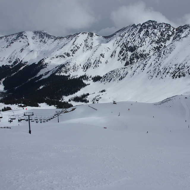
A Basin by Tom
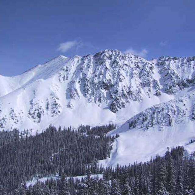
Couloirs above and beyond the East Wall, A-Basin, CO by tw
A Basin by Tom
Other resorts in USA - Colorado are reporting: powder (0) / good piste (0)
The above table gives the weather forecast for Arapahoe Basin at the specific elevation of 3286 m. Our sophisticated weather models allow us to provide snow forecasts for the top, middle and bottom ski stations of Arapahoe Basin. To access the weather forecasts for the other elevations, use the tab navigation above the table. For a wider view of the weather, check out the Weather Map of United States.
Click here to read further information on freezing levels and how we forecast our temperatures.
Visitor Reviews of Arapahoe Basin
Overall 3.6 Based on 4 votes and 3 reviews
- Snowsure
- Variety of pistes
- Vote
- Derek from United States writes:
A-Basin is phenomenal for intermediate and advanced skiers and snowboarders!! I've ridden most of Summit County and still consider this place the best of them all. Great terrain all over the place!!! You can access a ton of really fun terrains by any lift. If you're up for a steep bowl, just get off the main lift and strap on your snowshoes! There's a great trail to the left that leads right up to a peak. This is great, steep and deep if you're up for it. Bomb the fresh snow or carve out some giant flowing curves. Very smooth ride. And if you're not up to it, at least you can watch others brave it in full view from the lift. In the Spring, a ton of locals just hang out in the parking lot and barbeque! It's like a beach party. In fact, they call the front part of the lot...what else?? THE BEACH! Kegs and foosball are a local delight on those beautiful Spring days. So pack 'em up and move 'em out! This place is usually open until July 4!!!!!
Visitor Reviews of Arapahoe Basin
Derek from United States writes:
A-Basin is phenomenal for intermediate and advanced skiers and snowboarders!! I've ridden most of Summit County and still consider this place the best of them all. Great terrain all over the place!!!
You can access a ton of really fun terrains by any lift. If you're up for a steep bowl, just get off the main lift and strap on your snowshoes! There's a great trail to the left that leads right up to a peak. This is great, steep and deep if you're up for it. Bomb the fresh snow or carve out some giant flowing curves. Very smooth ride. And if you're not up to it, at least you can watch others brave it in full view from the lift.
In the Spring, a ton of locals just hang out in the parking lot and barbeque! It's like a beach party. In fact, they call the front part of the lot...what else?? THE BEACH! Kegs and foosball are a local delight on those beautiful Spring days. So pack 'em up and move 'em out! This place is usually open until July 4!!!!!
Free Snow-Forecast.com weather widget for your website
The Arapahoe Basin skiing weather widget is available to embed on external websites free of charge. It provides a daily summary of our Arapahoe Basin snow forecast and current weather conditions. Simply go to the feed configuration page and follow the 3 simple steps to grab the custom html code snippet and paste it into your own site. You can choose the snow forecast elevation (summit, mid-mountain or bottom lift) and metric/imperial units for the snow forecast feed to suit your own website…. Click here to get the code.
View detailed snow forecast for Arapahoe Basin at:
snow-forecast.com

 Nearest