


Global Weekly Snow Roundup #314
Weekly Global Snow News, updated 14 May 2026: Fresh snowfall in Argentina, Australia and Lesotho signals winter’s approach, while Japan maintains the world’s deepest snowpack.

Next 4 days weather summary:A light covering of new snow on Fri night turning to drizzle on Mon afternoon. Freeze-thaw conditions (max 7°C on Mon afternoon, min -1°C on Fri night). Wind will be generally light. | Days 5-7 weather summary:Light rain (total 9.0mm), mostly falling on Mon night. Very mild (max 10°C on Wed afternoon, min 3°C on Mon night). Wind will be generally light. | |||||||||||||||
Saturday 16 | Sunday 17 | Monday 18 | Tuesday 19 | Wednesday 20 | ||||||||||||
night | AM | PM | night | AM | PM | night | AM | PM | night | AM | PM | night | AM | PM | night | |
light snow | light snow | light snow | light snow | light snow | some clouds | some clouds | cloudy | rain shwrs | light rain | light rain | light rain | light rain | cloudy | some clouds | cloudy | |
km/h | ||||||||||||||||
Snow map |  |  | 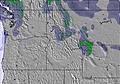 | 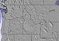 |  |  | ||||||||||
4 | 2 | 1 | 1 | — | — | — | — | — | — | — | — | — | — | — | — | |
— | — | — | — | — | — | — | — | 1 | 2 | 2 | 2 | 3 | — | — | — | |
max °C | 0 | -1 | 1 | 0 | 1 | 6 | 5 | 5 | 7 | 6 | 4 | 6 | 5 | 5 | 10 | 8 |
min °C | -1 | -1 | 0 | -1 | -1 | 3 | 3 | 4 | 6 | 3 | 3 | 5 | 3 | 3 | 9 | 6 |
-5 | -6 | -4 | -5 | -1 | 2 | 1 | 2 | 4 | 1 | 1 | 3 | 1 | 2 | 7 | 4 | |
99 | 98 | 91 | 99 | 94 | 75 | 76 | 84 | 62 | 97 | 97 | 88 | 99 | 87 | 63 | 88 | |
1250 | 1150 | 1400 | 1150 | 1450 | 2150 | 2100 | 2050 | 2250 | 1950 | 2000 | 2200 | 2450 | 2700 | 3250 | 3150 | |
— | 5:28 | — | — | 5:26 | — | — | 5:24 | — | — | 5:24 | — | — | 5:22 | — | — | |
— | — | — | 8:36 | — | — | 8:37 | — | — | 8:38 | — | — | 8:39 | — | — | 8:40 | |
Latest snow reports near Alpental At The Summit:
| Top snow depth: | — |
|---|---|
| Bottom snow depth: | — |
| Fresh snowfall depth: | 6 cm |
| Last snowfall: | 14 May 2026 |
| Snow Alerts | Create Alert |
0.0 | Bluebird Powder days Fresh snow, mostly sunny, light wind. |
|---|---|
0.2 | Powder days Fresh snow, limited sun, any wind. |
0.0 | Bluebird days Average snow, mostly sunny, light wind. |
The above table gives the weather forecast for Alpental At The Summit at the specific elevation of 1304 m. Our sophisticated weather models allow us to provide snow forecasts for the top, middle and bottom ski stations of Alpental At The Summit. To access the weather forecasts for the other elevations, use the tab navigation above the table. For a wider view of the weather, check out the Weather Map of United States.
Click here to read further information on freezing levels and how we forecast our temperatures.
Overall 3.0 Based on 22 votes and 10 reviews
Both Alpental (plus Snoqualmie Pass back country) and Stevens are situated at passes which divide two very different air masses; often cold continental high pressure and maritime low pressure (the later driven by prevailing westerlies, over the longest fetch on the planet). The Cascade Mountains offer up one of the steepest slopes anywhere on earth. Moist air is forced up causing winter precip nearly unmatched anywhere giving these places arguably more powder days per steep than anywhere else. Combine that with the notorious low level "easterly flow" that can maintain lower temps than anywhere at these elevations (just fractions of a mile to the west) and you've got winter wonderlands like no others. Alpental, however, has little in the way of any "bunny" slopes, separating this mountain and it's regulars from other areas with pretty much only serious to hard core skiers. This place is not for Texas wanna-be skiers, or anyone looking for a 5 star hotel with a hot tub....go back to Seattle.
Will from United States writes:
Both Alpental (plus Snoqualmie Pass back country) and Stevens are situated at passes which divide two very different air masses; often cold continental high pressure and maritime low pressure (the later driven by prevailing westerlies, over the longest fetch on the planet). The Cascade Mountains offer up one of the steepest slopes anywhere on earth. Moist air is forced up causing winter precip nearly unmatched anywhere giving these places arguably more powder days per steep than anywhere else. Combine that with the notorious low level "easterly flow" that can maintain lower temps than anywhere at these elevations (just fractions of a mile to the west) and you've got winter wonderlands like no others. Alpental, however, has little in the way of any "bunny" slopes, separating this mountain and it's regulars from other areas with pretty much only serious to hard core skiers. This place is not for Texas wanna-be skiers, or anyone looking for a 5 star hotel with a hot tub....go back to Seattle.
Read 9 more reviews of Alpental At The Summit or submit your own


 Nearest