


Global Weekly Snow Roundup #314
Weekly Global Snow News, updated 14 May 2026: Fresh snowfall in Argentina, Australia and Lesotho signals winter’s approach, while Japan maintains the world’s deepest snowpack.

Next 4 days weather summary:A light covering of new snow, mostly falling on Fri night. Becoming milder with light rain (total 8.0mm) on Fri night. Very mild (max 11°C on Mon afternoon, min 1°C on Fri night). Wind will be generally light. | Days 5-7 weather summary:Light rain (total 9.0mm), mostly falling on Mon night. Very mild (max 14°C on Wed afternoon, min 5°C on Mon night). Wind will be generally light. | |||||||||||||||
Saturday 16 | Sunday 17 | Monday 18 | Tuesday 19 | Wednesday 20 | ||||||||||||
night | AM | PM | night | AM | PM | night | AM | PM | night | AM | PM | night | AM | PM | night | |
light snow | light snow | light rain | light snow | light snow | some clouds | some clouds | cloudy | rain shwrs | light rain | light rain | light rain | light rain | cloudy | some clouds | cloudy | |
km/h | ||||||||||||||||
Snow map |  |  | 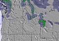 | 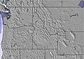 |  |  | ||||||||||
3 | 2 | — | 1 | — | — | — | — | — | — | — | — | — | — | — | — | |
2 | — | 4 | 1 | — | — | — | — | 1 | 2 | 2 | 2 | 3 | — | — | — | |
max °C | 2 | 2 | 4 | 2 | 4 | 9 | 6 | 9 | 11 | 8 | 6 | 9 | 7 | 9 | 14 | 10 |
min °C | 1 | 1 | 3 | 1 | 2 | 8 | 2 | 6 | 10 | 5 | 5 | 8 | 5 | 6 | 13 | 6 |
-2 | -3 | 0 | -2 | 2 | 8 | 1 | 5 | 9 | 4 | 4 | 7 | 4 | 6 | 12 | 4 | |
99 | 98 | 89 | 99 | 90 | 72 | 80 | 80 | 59 | 97 | 95 | 84 | 99 | 82 | 60 | 88 | |
1250 | 1150 | 1400 | 1150 | 1450 | 2150 | 2100 | 2050 | 2250 | 1950 | 2000 | 2200 | 2450 | 2700 | 3250 | 3150 | |
— | 5:28 | — | — | 5:26 | — | — | 5:24 | — | — | 5:24 | — | — | 5:22 | — | — | |
— | — | — | 8:36 | — | — | 8:37 | — | — | 8:38 | — | — | 8:39 | — | — | 8:40 | |
Latest snow reports near Alpental At The Summit:
| Top snow depth: | — |
|---|---|
| Bottom snow depth: | — |
| Fresh snowfall depth: | 6 cm |
| Last snowfall: | 14 May 2026 |
| Snow Alerts | Create Alert |
0.0 | Bluebird Powder days Fresh snow, mostly sunny, light wind. |
|---|---|
0.0 | Powder days Fresh snow, limited sun, any wind. |
0.0 | Bluebird days Average snow, mostly sunny, light wind. |
The above table gives the weather forecast for Alpental At The Summit at the specific elevation of 957 m. Our sophisticated weather models allow us to provide snow forecasts for the top, middle and bottom ski stations of Alpental At The Summit. To access the weather forecasts for the other elevations, use the tab navigation above the table. For a wider view of the weather, check out the Weather Map of United States.
Click here to read further information on freezing levels and how we forecast our temperatures.
Overall 3.0 Based on 22 votes and 10 reviews
Alpental is the worst ever, you should never, ever go there. Stay away, really and truly, stay away. Go to Summit West or Central, or even better, another area entirely. All the rad people go to Crystal or Stevens, man. Yeah, Alpy sucks. That's what makes it so hard living there. I really should move away, but I will probably live there forever with my luck...
Coop from United States writes:
Alpental is the worst ever, you should never, ever go there. Stay away, really and truly, stay away. Go to Summit West or Central, or even better, another area entirely. All the rad people go to Crystal or Stevens, man. Yeah, Alpy sucks. That's what makes it so hard living there. I really should move away, but I will probably live there forever with my luck...
Read 9 more reviews of Alpental At The Summit or submit your own


 Nearest