World Snow Roundup #75
Issued: 19th February 2019
By Patrick “Snowhunter” Thorne
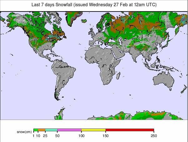
Our latest roundup of snow conditions around the world. Each section that follows below goes into detail country by country. Clicking the map thumbnail will take you to our dynamic snow forecast map for the latest detail (where you can also overlay live weather & reported conditions). Weather outlooks for Europe and North America can be found at the end of this roundup.

INTRODUCTION:
An unusual week for snowfall, this season, in Europe. Particularly compared to the start of this year as there’s hardly been any new snow. After the huge snowfalls in the Eastern Alps in January and the decent snowfalls pretty well everywhere else over the past month, it has simply stopped across much of Europe.
Instead, it seems spring has arrived a little early. Actually, most skiers have been delighted as after the fresh snowfall the weekend before last the wall-to-wall sunshine and pleasant temperatures have led to perfect conditions on the pistes, particularly at higher altitudes. However, powder is proving increasingly difficult to find. For most areas, the week ahead looks like more of the same.
In Scandinavia, it has been a mixed picture with almost every type of weather hitting them: very low temperatures, above zero temperatures, strong winds and fog. Scotland just got the very strong winds and warm temperatures which have, unfortunately, decimated the snow cover there.
Across the Atlantic, it is a very different picture. It has been dumping down from coast to coast in North America and on the Pacific Coast, in particular. The February snow totals are staggering with some resorts reporting 4 – 5
INDEX:
Austria / France / Switzerland / Italy / Andorra / Norway/Sweden / Germany / Bulgaria / Scotland / Japan / USA / Canada / Europe / North America
Austria
This is the first week of 2019 when there’s been (virtually) no snow reported in Austria. Instead,
FRANCE

It’s an almost identical picture for France with the exception of a few flakes down in the far southern Alps and the Pyrenees. A handful of resorts started the week this way. Otherwise, it has been almost wall to wall sunshine and lovely spring snow conditions for those not in search of powder. With no significant snowfall for 10 days it’s getting increasingly hard to find, even high up. The conditions do begin to feel like the start of the main ski touring season, however. Again, relatively healthy snowfalls over the first six weeks of the year mean that the bases are good from top to bottom at most French resorts, enabling them to withstand the thaw. The country’s deepest base stats have dropped only a little on a week ago. However, they are still topped by the Pyrenean resort of Cauterets (300/420cm) with resorts in the Grand Massif region, including Flaine (135/280cm) posting the deepest base in the Alps. But most of the big name ski areas in the French Alps are very close behind, including Les Arcs (150/270cm).
SWITZERLAND

Switzerland, has also enjoyed a dry, sunny week. The
ITALY

There’s been no fresh snow in Italy either. Incidentally, there was very little fresh snow the weekend before last when it was snowing further north in Austria, France
ANDORRA
An almost identical scenario to the Dolomites and the Southern Alps is occurring in the Pyrenees: no fresh snow to note for over a fortnight. There are sunny skies, light to moderate winds and temperatures climbing to +5-8C in resort by

NORWAY/SWEDEN

After the wild weather variations a week ago, things have quietened down a good deal in Scandinavia with fairly stable weather conditions: temperatures around zero celsius and mostly clear skies. Although the area has experienced the occasional light snowfall. Ski areas in Sweden have actually posted some of the biggest snowfalls in Europe over the past week, even though they’re not that big. On Sunday Bjorkliden (70/70cm) reported the biggest 24-hour accumulation on the continent for
GERMANY

Snow kept falling at German ski areas a little longer than elsewhere at the start of last week. However, it is at least a week here too since there was any snowfall of note that fell on German ski slopes. Again, for most well-known resorts in the country, that’s not a huge issue at present as the impressive January snowfalls have built deep bases. The Zugspitze glacier (0/410cm) continues to post the deepest snow in Germany on the country’s highest slopes. Reit
BULGARIA
Bulgaria has had a largely dry and sunny week, in common with much of Europe. However, it has actually stayed a little cooler than the Alps until recent days when temperatures in-resort have tended to climb well above freezing, although remaining mostly sub-zero on the slopes. So with no fresh snow, there’s little change to the snow depth tables with Pamporovo (225/255cm) still on top. Bansko (110/200cm) hosts one of the first World Cup meets, later this week, after the World Championships in Are, Sweden ended at the weekend. It has the race pistes currently closed to the public. However, all other runs are open.
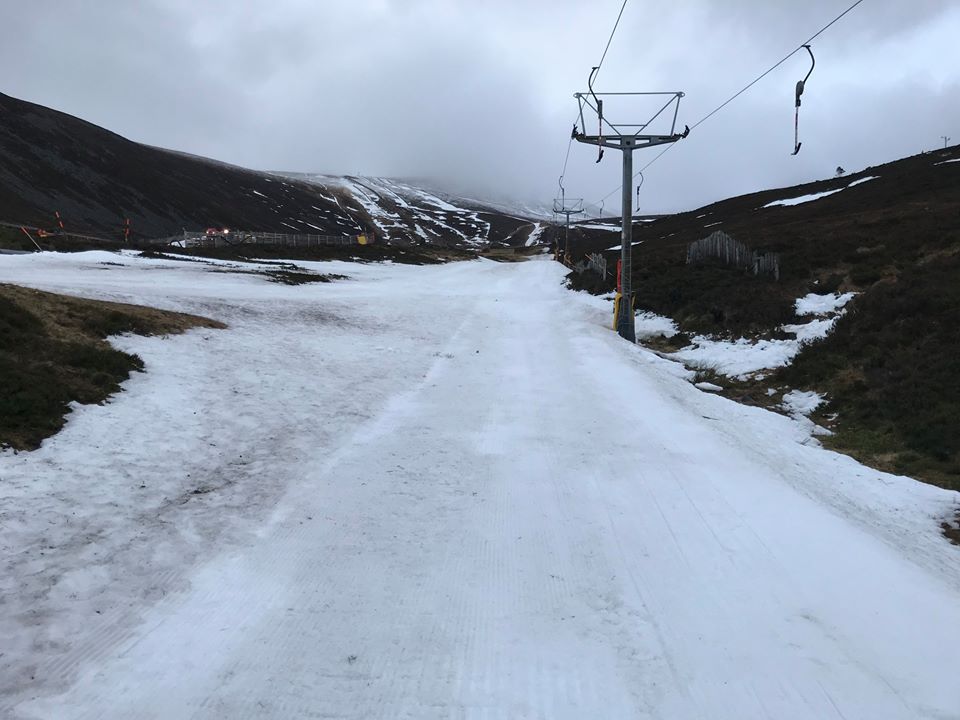
SCOTLAND

Alas, it has not been a happy week for Scottish skiers. After a fortnight of relatively cold conditions and little sign of the strong winds, that are infamous on the country’s slopes, those gales have returned and brought with them warm temperatures day and night which
JAPAN
A fairly usual week of regular 10-20cm powder dumps on Hokkaido with Niseko (165/370cm) just about at its
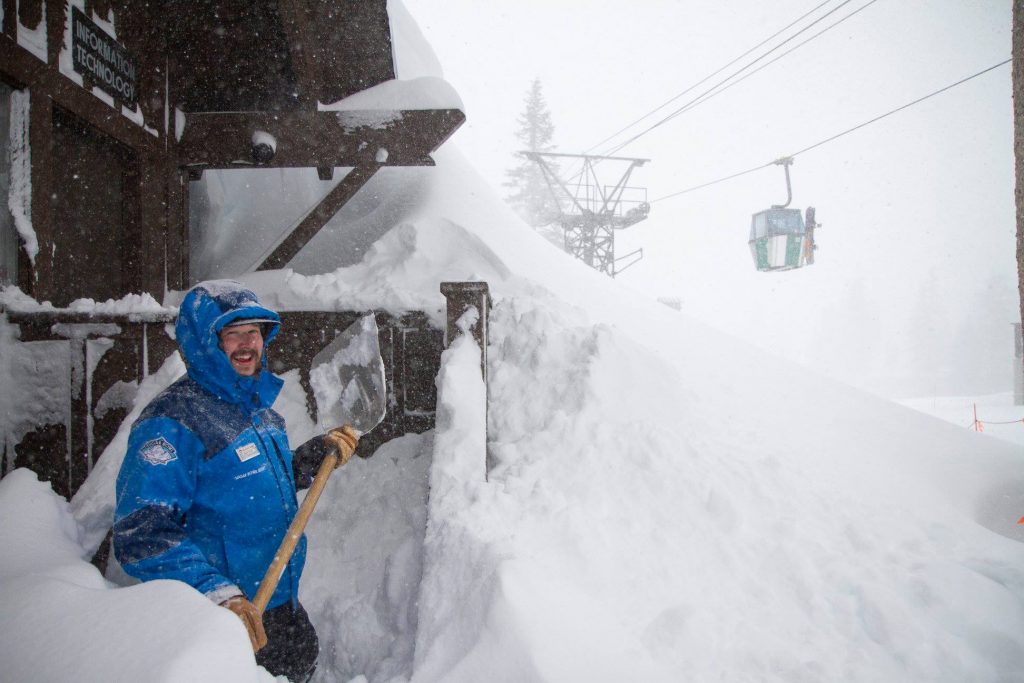
USA

There have been some incredible snowfalls on the US Pacific coast with several Californian ski areas, including Mammoth Mountain (381/572cm) and Squaw Valley (356/566cm), reporting they have now had more snowfall this February than in any previous February in their long histories. In Mammoth’s case, this was breaking a record set in February 1986. February snowfalls are up around the 4 –
CANADA

The past week has been snowier than the one before in Canada with accumulations of up to 50cm over the weekend. The biggest falls have been on the BC coast but there has been more snow for Quebec, in the East, too. Indeed, Mont Tremblant (453/453cm) continues to post the deepest base in the country after another 17cm of snow at the weekend. Whistler Blackcomb (252/252cm) has one of the deepest bases in the West and also reports fresh snow in recent days.
EUROPEAN WEATHER OUTLOOK

After a week with almost no snow in the Alps, there’s not a huge amount in the short-term forecast either; it looks like it should cool towards the end of the week. However, there are early signs of a return to more changeable conditions going into the weekend with light snow forecast on Friday/Saturday for Austria and Germany but nothing really for the western Alps, France or Switzerland, on the horizon as yet. It looks like a continuation of
NORTH AMERICAN WEATHER OUTLOOK

It is looking fairly snowy across much of the US for the week ahead although the huge snowstorms in California look like they’ll now ease away a good deal. However, parts of Colorado and Utah could see as much as 30-40cm more snow over the next few days. There’ll be some more snow on the east coast too. But more like 10-20cm over the next few days here.