World Snow Roundup #70
Issued: 15th January 2019
By Patrick “Snowhunter” Thorne
Our latest roundup of snow conditions around the world. Each section that follows below goes into detail country by country. Clicking the map thumbnail will take you to our dynamic snow forecast map for the latest detail (where you can also overlay live weather & reported conditions). Weather outlooks for Europe and North America can be found at the end of this roundup.

INTRODUCTION:
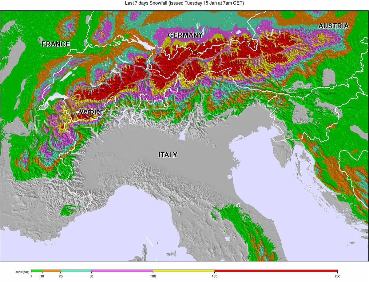
The third successive week of heavy snowfall in the Eastern Alps brought some of the most significant accumulations yet to Austria, southern Germany and Eastern Switzerland over the weekend with some resorts reporting as much as a metre of snow in 24 hours (again) and an accumulation of 3 metres (10 feet) in the past week (again).
The ongoing snowfall closed ski slopes, access roads, rail lines and occasionally airports. The avalanche danger level reached its highest level in parts of Austria making getting on to the slopes somewhat problematic. The good news for everyone from road-workers to skiers and boarders though is that there are signs of it ending, or at least a lull, this week so things should become easier.
INDEX:
Austria / France / Switzerland / Italy / Andorra / Norway/Sweden / Germany / Bulgaria / Scotland / Japan / USA / Canada / Europe / North America
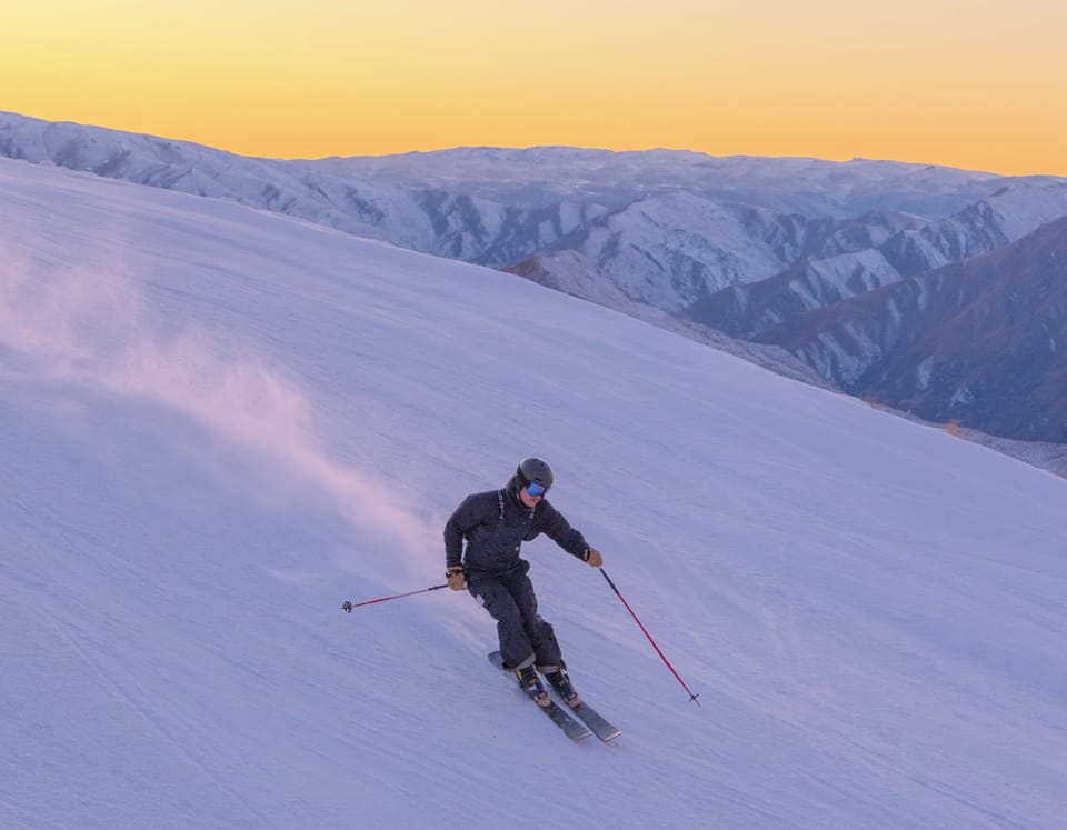
Austria
After the latest huge snowfalls in Austria, the greatest of which were from last Saturday to Monday, it’s finally quietened down a little in Austria after three weeks of heavy snow in the north and west of the country. At the time of writing, avalanche danger levels were down from the maximum level 5, or next highest level 4, to 3; still ‘considerable’ but not quite so dangerous. Always take appropriate precautions. Previously closed ski areas have begun re-opening and resorts that were all but cut off by road closures are mostly accessible again. At the time of writing the deepest reported snow in Austria is at the resort of Loser Altaussee (150/490cm) in the province of Styria and had an avalanche risk of 5. The second deepest in the world at present is St. Anton am Arlberg (95/480cm).
FRANCE

Although the Eastern Alps have been getting the headlines due to the on-going huge snowfalls, it’s a much improved picture in the French Alps after two much more manageable snowfalls over the past week. One storm on Wednesday/Thursday last week, the other last weekend into Monday. These brought between 30 and 60cm of fresh snow over the past 7 days to many of the country’s leading ski areas, refreshing cover on slopes that had seen no natural snowfall since before Christmas (although it had been cold enough for snowmaking most of that time). As a result, the major French resorts continue to enjoy good on-piste snow conditions and now the return of fresh off-piste snow for freeriding but haven’t had the closures and access problems faced by ski regions further East. La Rosiere (90/150cm) has the deepest base in the county with Tignes (105/205cm) and Val d’Isere (105/205cm) not far behind.
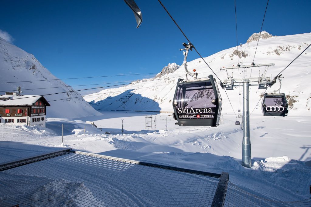
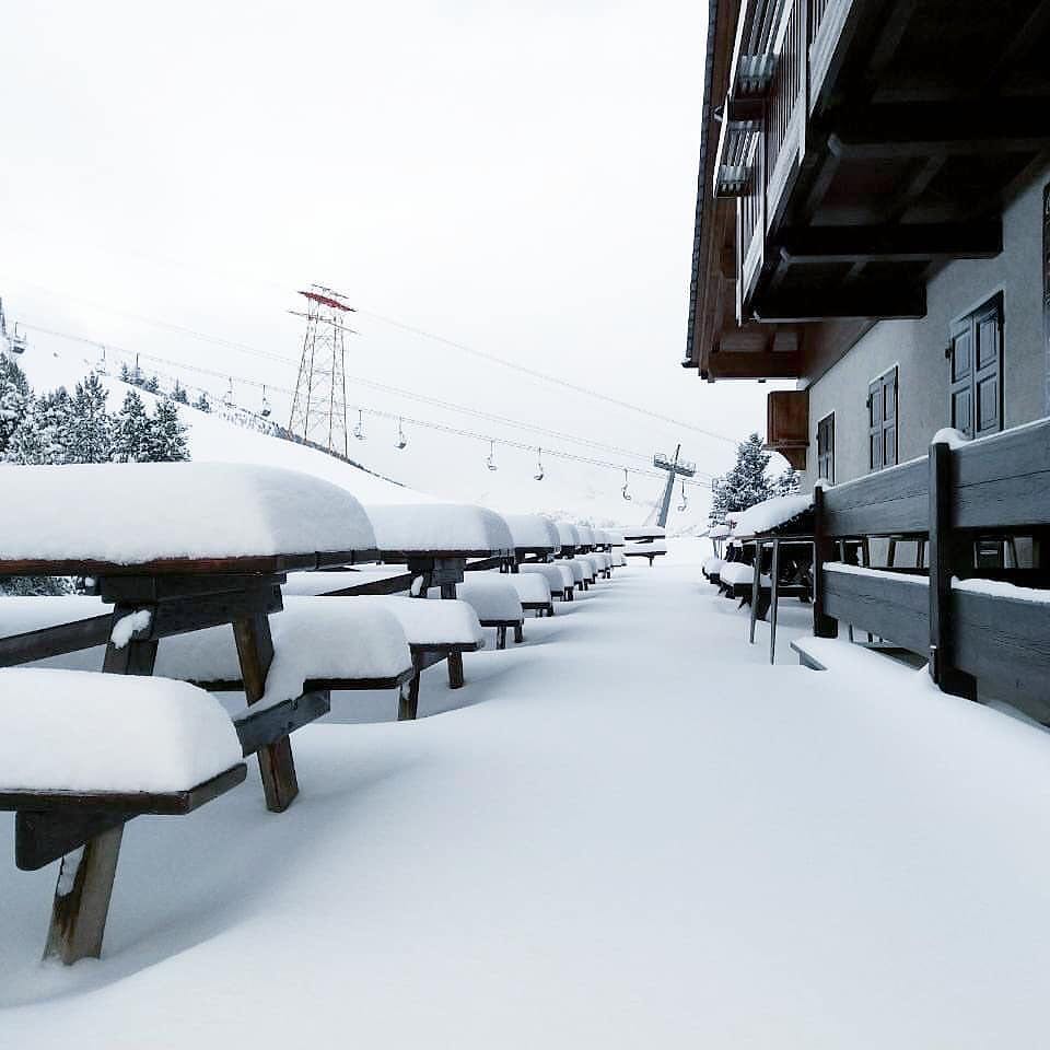
SWITZERLAND

There were more considerable snowfalls in Eastern Switzerland at the end of last week and through the weekend. Andermatt (65/550cm) continued to post the deepest base in the world and went through the 5 metre barrier after another 40cm of snow fell there on Saturday. ArosaLenzerheide (150/200cm) meanwhile claimed the biggest 24 hours snowfall on Sunday, reporting 90cm of fresh snow. This time it’s not just been the east of the country getting dumped on, but also the west with 20-50cm of fresh snow reported in the past week in the Valais and other western regions. However, this snowfall was much more in the 4 Valleys, where for example, 375km (over 90%) of runs were open at the start of this week whilst in Engelberg (74/400cm), all the snow and related issues limited open terrain to about 25% of their skiable area on Monday.
ITALY

The snowfall that first hit Austria and eastern Switzerland and more recently France and western Switzerland, all to the north, has largely missed Italy, other than a few areas on its northern and western borders. The Dolomites have been very cold but very dry. That’s not a huge problem for them so long as you’re happy on the groomed runs as they’re masters at snowmaking and can fully open resorts with machine-made snow and at many, on lower runs at least, that’s what there is. Things look like they’re finally changing in the week ahead (see forecast) after a mostly dry month for most of the country. Currently, the mid-sized ski area of San Domenico di Varzo (20/340cm) in the Piemonte region in the west continues to post the deepest snow numbers in the country with larger Madesimo (45/250cm) in Lombardy reporting the second deepest. Unlike the ski areas buried under fresh snow in Austria further north, they’ve been and remain fully open with all groomed slopes open and all lifts operating.
ANDORRA
There has been an improvement in the conditions on Andorra’s slopes with a 10cm snowfall, the first since before Christmas. Although bigger accumulations were reported on the French side of Europe’s southerly mountain chain. As a result, the number of trails regularly open at the largest area in the region, Grandvalira (10/50cm), has jumped from 80+ to 90+ this week; about three-quarters of the total possible. Much more snow would be welcome and there’s a little in the forecast. But there’s still plenty of groomed runs open anyway.
NORWAY/SWEDEN

Some of the most significant snowfalls of the season so far reported in Eastern Norway with Bjorli Skisenter, (150cm/180cm) posting 90cm (3 feet) of snow falling over the weekend. It now has the deepest base in Scandinavia of the open resorts and only Fonna glacier reports 2 metres so far; lying there in readiness for May!. Other ski areas in the region did not post such big numbers, but 20-40cm was claimed by most. In the west of the county, Voss (70/70cm) on the coast had 28cm of snow over the same period. Hemavan (60-80cm) in Sweden posted the most significant snowfall there in the last few days; 20cm and has the deepest base in the country too.
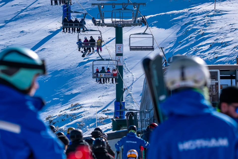
GERMANY

As reported in the mainstream media, Southern Germany was one of the hardest hit by the snowstorms of the past three weeks with many ski areas closed; several, like Balderschwang (150/200cm) in the Allgau region, wholly or partially cut-off. Those that were open could only open a small part of their ski areas for safety reasons. It’s a big change from pre-Christmas when areas open were limited by lack of snow cover. As with Austria to the south. However, that situation has now eased with the snowfall much lighter since the last big storm, which brought up to over 90cm/3 feet (to the Zugspitze Glacier 0/400cm) in 72 hours, ended on Monday. The Zugspitze, which was one of the few glaciers in the Eastern Alps that managed to stay open through much of the past few weeks, albeit with just a few runs open, also has the deepest base in the country.
BULGARIA
Bulgaria’s ski areas have had a snowy week which has further improved conditions there. All of the main areas are now posting bases of at least a metre, and all are either fully open or almost so with just a run or two still closed. Pamporovo (160/180cm), in the Rhodope mountains, has the country’s deepest base but the other areas aren’t far behind and almost all runs are open.
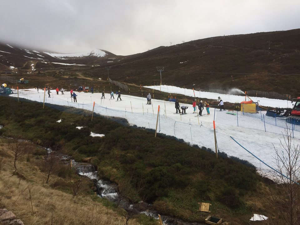
SCOTLAND

There’s still not enough snow for ski areas to fully open in Scotland although it has finally felt a little more like winter on the Scottish hills since the weekend with lower temperatures and small accumulations. This has also allowed ski areas to fire up snowmaking systems at times so there may be light at the end of the tunnel. The three ski areas that operate all-weather snowmaking systems, Cairngorm (20/20cm), Glencoe (20/20cm) and The Lecht (20/20cm) continue to offer small snowy areas for beginner lessons and play.
JAPAN
The snowfall slowed in Japan over the weekend and Niseko (125/260cm) only reported about 5cm of fresh snowfall over five days from Thursday to Monday. Regular snow deliveries have returned in the past 24 hours. However, the season-to-date total of over 5.3 metres of snowfall isn’t bad. Temperatures have been double digits below freezing. It’s a similar picture at Nozawa Onsen (100/225cm) which reported a 48cm snowfall in 24 hours last Wednesday but little since. Although, after a dry weekend it is starting to snow again here too.
USA

It has been a quieter week for much of the US with not much fresh snowfall reported since the weekend. Some of the most significant snowfalls have been in the southwestern corner of the country with Taos Ski Valley (99/117cm) in New Mexico reporting 28cm (11 inches) since Saturday. There was also good news in the east where states south of the north-eastern corner that had been suffering from unseasonably warm temperatures saw the mercury drop and fresh snow arrive, dramatically improving conditions in states like North Carolina. Whitetail Resort, (56/66cm) in Pennsylvania, posted another of the larger snowfalls of the past few days with 18cm (7 inches) in the last 72 hours. The deepest base in North America continues to be, as it so often is, at Mt. Baker (295/345cm) in Washington State in the North-western US although there’s been no fresh snow there so far this week.
CANADA

It’s been a quiet week in Canada for snowfall too with clear skies and low temperatures bringing some great days to enjoy the recent accumulations. Whistler Blackcomb (259/259cm) on the West Coast of BC continues to post the deepest base in the country after the huge snowstorms over the past month there, with December 2018 now officially their snowiest ever snowfall month. Temperatures have dropped in the east too and resorts in Quebec posted 20-40cm snowfalls over the weekend. The Massif du Sud (151/245cm) in Quebec is posting the second deepest base in the country.
EUROPEAN WEATHER OUTLOOK

It seems a change is on the cards in the Alps for the first time in a month. More snow forecast in the Western Alps than the Eastern for the week ahead. The difference isn’t huge but it does appear that French ski areas will see more substantial snowfalls this weekend than further east as conditions generally remain ‘snowy’ for the next few days. Accumulations of 10-50cm of snow by the start of next week are forecast. The forecast for Austria, Germany, Eastern Switzerland and the Eastern Alps as a whole is currently the ‘least snowy’ it has been since before Christmas. Still, snow is in the forecast for the week ahead but much lighter falls and with clear days in between. After light snowfall on Thursday, Friday currently looks clear with more light snow likely at the weekend. Seven day accumulations are likely to only be in the 10-30cm bracket across the country. Probably a welcome respite for most if it pans out as forecast. Italy’s forecast is looking closer to that of the Eastern Alps than the Western, with light or moderate snowfalls expected here over the rest of this week and into the weekend. Parts of the Dolomites should see another 20-30cm, and along western borders. In France, the country’s ski areas may receive up to 40cm of snow over the next 4-5 days. Elsewhere in Europe, it looks like there could be more snow in the Pyrenees towards the weekend. Hopefully, a little more in Andorra than last week, with 10-30cm possible. For Scotland, it is looking increasingly cold and wintery. So hopefully, it will not be long now until bases begin to build and get deep enough for ski areas to open.
NORTH AMERICAN WEATHER OUTLOOK

It will become more wintery again across the USA over the coming week with ski areas on the west, notably California and the Pacific Northwest, likely to see snowfall most days including some intense falls, most likely on Thursday. Less snow is forecast for Colorado and the East coast and probably not much more can be expected until early next week. It’s a similar picture over the Canadian border, to the north, with a snowy week ahead in the west. But little fresh snow expected until the weekend in Ontario and Quebec, on the East.