WORLD SNOW ROUNDUP #228
Issued: 2nd February 2022
By Patrick “Snowhunter” Thorne
European Roundup
North American Roundup
Asia Roundup
WORLD OVERVIEW
It was an odd January. In all the years we’ve been covering snow cover at the world’s ski areas it’s hard to remember a January when snow depths have been lower in most areas at this midwinter end of the month than they were at the start. But that’s the case for much of Europe and most of the west of North America. It’s not a huge problem as big December snowfalls mean all these areas actually have, on the whole, better than average snow cover, and eastern North America, which hadn’t had much December snow, has also caught up over the past month. It’s just, well, unusual.
Eastern North America has been the focus of fresh snowfall in the main ski regions over the past week with a weekend “weather bomb cyclone” caused by the rapid arrival of cold air from the north giving blizzard conditions that have hit the East Coast’s big cities. But brought snowy delights to the region’s ski areas.
Japan continues to post the deepest snowpack in the world, with some areas passing the 10 metres (33 feet) of snowfall this season-to-date mark over the past week. The deepest reported base here has passed 4.5 metres (15 feet) but the country will remain closed to international tourism until at least the end of the month.
In the wider world, there have been further reports of big snowfalls in the Atlas mountains of North Africa, where travel to Morocco is allowed to resume from next weekend, as well as snowfall for less usual locations like Jerusalem, in Israel.
EUROPE INTRODUCTION
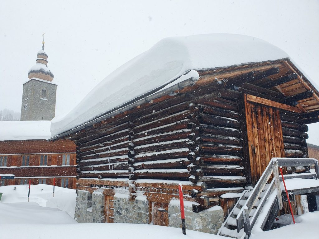
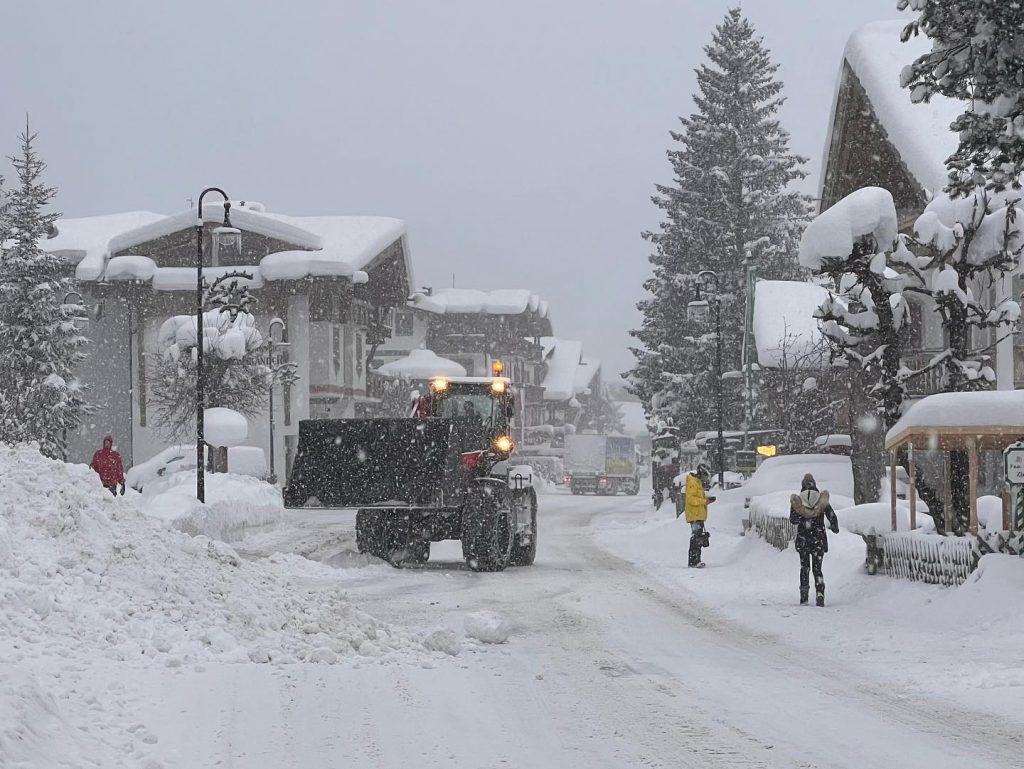
The Eastern Alps and more northerly areas in Eastern Europe as well as in Scandinavia have been the focus for fresh snowfall in Europe over the past seven days. In a repeat of the previous week, there was fresh snow for many ski areas in Austria while more westerly and southerly ski centres in the Alps initially missed out once more. Since Tuesday that’s changing though and the snowfall has become ever more widespread with ski areas in France and Switzerland getting fresh snow too. But it has been staying sunny for some, as has been the case in the Pyrenees. They have seen little fresh snow for over a month now yet still have Europe’s deepest base thanks to big December snowfalls. Other than the snow being hardpacked and temperatures a little warm, most ski areas in the sunshine aren’t complaining and have everything open. Where the snow fell the main problem was very strong winds driving the snow in, but once things eased the fresh cover was very welcome.
AUSTRIA
AUSTRIA REPORT Austria was again the main alpine ski nation seeing snowfall this past week with most ski areas across the country, though particularly in the north, reporting more fresh cover. Typically totals were 15-30cm (6-12 inches) of fresh but some like Filzmoos (100/160cm / 40/64″) reported as much as 50cm (20″) of snowfall in 24 hours at the weekend with the Zillertal Arena reported a similar accumulation on Monday-Tuesday. The snow was combined with strong winds at times leaving some areas to close higher lifts or in some cases close completely for periods. The snowfall has continued through the start of this week in most areas and base depths on glaciers are back over the two metres (80″) mark and the deepest base in the country reported at Loser (60/250 cm / 24/100″).
AUSTRIA FORECAST It looks like drier weather for the latter half of this week in the southwest of Austria but more snowfall further north and east towards the weekend. Sunshine should return to most areas in Tirol by the end of the week. Temperatures remain below freezing across the country.
SWITZERLAND REPORT Some Swiss ski areas have reported a little fresh snowfall up to the start of this week but not many and not a lot. Those that have, have been largely in the north and east of the country, with Toggenburg (15/60cm / 6/24”) in St Gallen posting successive 5cm (2”) accumulations over the weekend, not usually something to get excited about but after a mostly dry January, something at least. However, the picture from Monday has been more promising with more widespread snowfall reported and temperatures dipping back below freezing even at resort bases too. The snowfall has been heaviest in the east of the country, with Davos (91/158cm / 36/63”) reporting 50cm (20”) on Tuesday, and so far mostly light to moderate falls. But it’s set to intensify further over the next few days. Engelberg (20/240cm / 8/96″) continues to report the country’s deepest base upon its Titlis glacier.
SWITZERLAND FORECAST It’s looking promising for some of the best snowfalls in a month over large parts of Switzerland later this week. Some areas in Graubunden could see several feet (60cm) of snowfall totals by the weekend
FRANCE REPORT Unfortunately, the French Alps have not benefited so much from the recent snowfall as further east in Austria and parts of Switzerland. For most areas, it has been another mostly sunny week, rather warm at bases but staying below freezing up on the higher slopes. There have been some snow showers, especially on Monday, and the trend is towards something colder and snowier. But, overall, January was a largely dry and sunny month. The snowfall from early December continues to serve French ski areas well and those down in the Pyrenees have continued to post the country and continent’s deepest, other than over in the far east at Sochi. The 3 Valleys (110/160cm / 44/64”) continue to post more than 95% of their terrain open (the country and the world’s largest inter-linked ski area).
FRANCE FORECAST It is looking promising for snowfall to reach more French slopes over the next few days. Probably light to moderate for most rather than a huge dump but it should provide a welcome refresh of the groomed terrain at least and maybe even some fresh powder pockets for some.
ITALY REPORT Another largely sunny week for much of the country but there have been snow showers in the north and east so there’s a different feel in the air here. Almost all slopes in the country remain open, the only real issue, in the past week, once again being strong winds at altitude which closed higher slopes and runs over the weekend. But most of the terrain in the country’s biggest ski region, Dolomiti Superski remained open and the Via Lattea (230/40cm / 8/16”) continues to have 75% of its 400km I(250 miles) of runs open despite reporting a still rather thin base.
ITALY FORECAST Things do finally seem to be changing towards more unsettled and snowy weather right across Italy. There’s more snow forecast for the latter half of this week in the northern alpine regions with even the dry-so-far-this-year Dolomites expecting 5-10cm (2-6 inches) of fresh snow too.
GERMANY REPORT There’s been plenty of snowfall on German slopes over the past week, in fact for many areas this has been the snowiest week of the season so far, and it is still coming down. Some resorts have reported more than 50cm (20″) in the past week with temperatures in the range of freezing to minus ten Celsius and some stormy weather at times impacting operations. The deepest base in the country is on the country’s highest slopes on the Zugspitze (145/155cm / 58/62”) with Reit im Winkl (43/135cm / 17/53”) posting the largest area open with 38km pr 90% of its terrain accessible.
GERMANY FORECAST The snowfall hasn’t stopped yet and is expected to continue through the rest of this week in most areas with temperatures staying low. Another 20-40cm (8-16”) is likely for some areas by the weekend.
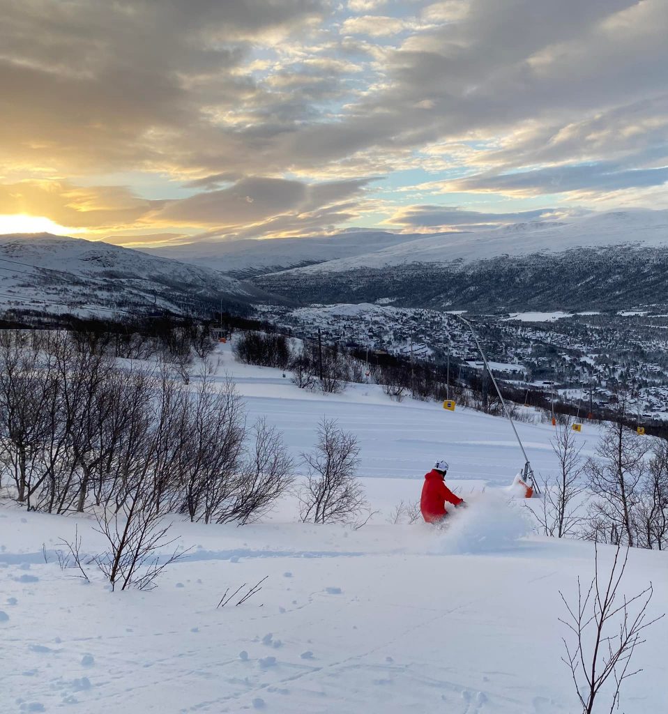
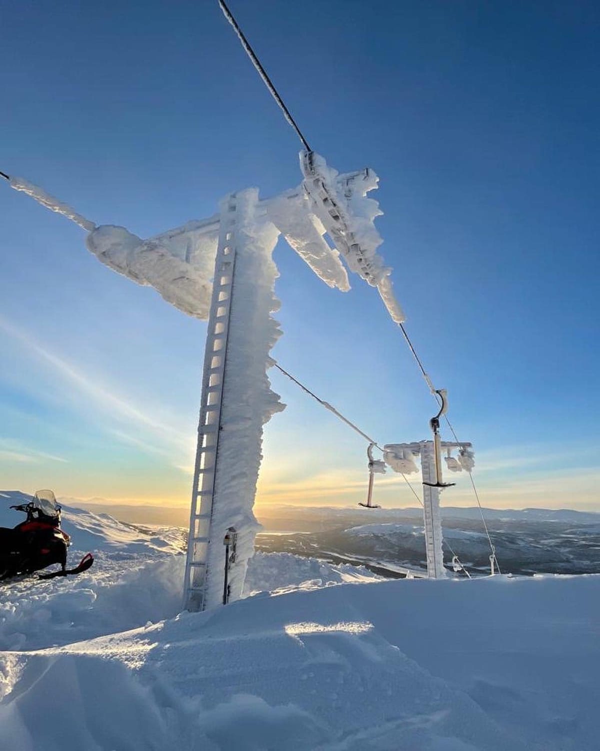
SCANDINAVIA REPORT Promising mid-winter conditions in Scandinavia with temperatures well below freezing across the region and regular snow showers reported for most areas keeping the snow fresh. Most are having sunny days in between to enjoy the new snow. Daylight hours are also improving fast and the world’s most northerly ski area up on Norway’s North Cape opened for the 2022 season on Saturday. The deepest reported base in the region, at Bjorli (125/135cm / 50/54”) in Norway, has grown by 25cm (10”) on a week ago.

SCANDINAVIA FORECAST More snowfall and sunny spells for the remainder of the week with temperatures in the range of freezing down to about 15 degrees below. Up in Lapland, it will be dry through until the weekend when fresh snowfall is forecast.
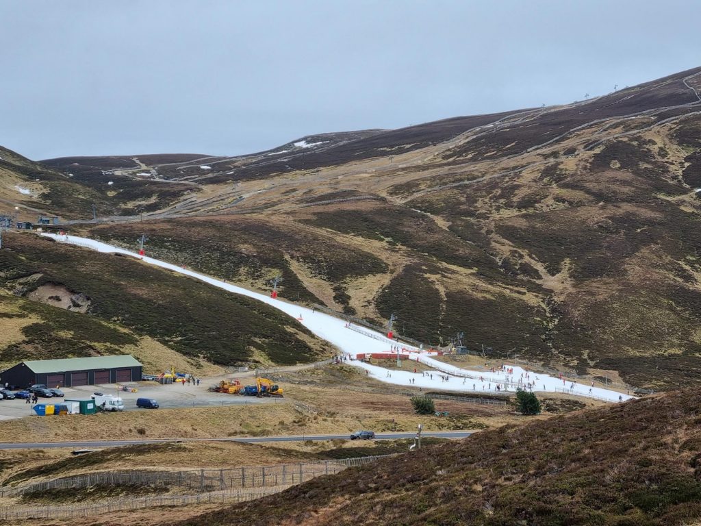
SCOTLAND REPORT There are finally some promising signs on Scottish skis slopes after a warm and dry January reduced operations to very limited base-area runs maintained by all-weather snowmaking machines, as the surrounding mountains lost almost all of their snow cover. It has finally turned colder and there have been the first snowfalls for the best part of a month for most areas. More is needed before the season proper can begin, but the February forecast is looking more promising than January. In the meantime, those small areas remain open.
SCOTLAND FORECAST A much colder and snowier picture than we’ve seen since last December with the potential for 20-40cm of snowfall by the weekend, hopefully beginning to transform the slopes. Temperatures are still fairly marginal, but hopefully staying cold enough for snow that falls to stick around.
SPAIN / ANDORRA REPORT Although things have been turning snowier further north, the dry and sunny conditions in the Pyrenees continue. Despite that, the area continues to have virtually all terrain open and some of the best snow depths in Europe still, thanks to the big falls of late November and early December, the majority of which remains lying there. Porté Puymorens (100/280cm / 40/112”) actually has the deepest upper-slopes base in the region, and western Europe, as it has had for the past two months, despite a little thawing over the intervening two months. Baqueira Beret (170/275cm / 68/110”) is close behind and has more at its base and along with Grandvalira (100/150cm / 40/60”) is one of two resorts in the region posting more than 160km (100 miles) of slopes open. It has also been hosting the Freeride World Tour over the past week.
SPAIN / ANDORRA FORECAST It’s yet another week of sunny skies ahead in the Pyrenees with the chance of a little more cloud that could give a dusting of snow at the weekend. Temperatures remain well below freezing up high but creeping 5-10 degrees above in the daytime at mountain bases.
BULGARIA / ROMANIA REPORT A largely sunny week in Bulgaria and Romania, the former celebrating an easing of travel restrictions from most countries that started on Tuesday. However, more unsettled conditions have rolled in with the start of the week with many areas seeing moderate snowfalls over the past 48 hours. Borovets (135/165cm / 54/66”) has a very healthy snow depth, the region’s deepest, Bansko (10/100cm / 4/40”) the most skiable terrain including the long run back to the resort base.
BULGARIA / ROMANIA FORECAST More snowfall is expected for most ski centres in the region in the latter half of this week before skies clear and sunshine returns to end the week and through the weekend. Temperatures staying cold, typically around freezing at resort level, five to ten degrees below on higher slopes.
CZECH REPUBLIC / SLOVAKIA REPORT It’s a cold and snowy week for most parts of the Czech and Slovak Republics with temperatures ranging from a few degrees to 10 or 15 below freezing and frequent snow showers. The region’s largest ski area at Jasna (40/80cm / 16/32”) is almost fully open and is reporting one of the region’s deepest snowpacks. It has extended lift opening hours to 4pm from the start of February. Špindlerův Mlýn (35/55cm / 14/22”), the largest in the Czech Republic had struggled to open terrain after warm, dry weather earlier in the season but now has 90% of its slopes open, the most so far this winter.
CZECH REPUBLIC / SLOVAKIA FORECAST Conditions look set to continue to be snowy with potentially up to 50cm (20”) more snowfall for some higher areas by the end of the weekend and snowfall possible most days. It’s looking colder and snowier in the east of the region with some sunny spells in the west.
NORTH AMERICA
NORTH AMERICA INTRO A fairly quiet week for weather for much of North America with limited fresh snowfall to report across much of the continent and remaining a little warm and dry in the west where snow depths are continuing to decline, except perhaps in Alaska and the far north. Very cold still in eastern Canada and New England and it is the north-eastern US that has again seen the most active weather fronts with several centres posting several feet of snowfall resulting from a major weekend storm hitting the eastern seaboard.
ROCKIES REPORT Another predominantly cold, sunny week in the Rockies as has been the norm for most areas for much of 2022 so far. There was a weak weather front bringing a few inches of snowfall to some centres, moving through on Tuesday. But the picture for most has been more non-stop sunshine and temperatures dipping quite low at altitude, as much as 20 or 30 degrees below freezing. Although once more getting above freezing in the afternoons down at resort bases. Park City (42/53” / 104/132cm), America’s largest ski area, reports itself finally 100% open more than two months after what should have been opening day. Wolf Creek (79/86” / 198/215cm) furthers south in Colorado continues to post the deepest base in the Rockies and remains fully open.
ROCKIES FORECAST After the midweek snowfall clears by Thursday, it’s back to a predominantly sunny picture once again with temperatures again ranging from a little above freezing at resort level not well below at altitude.
USA WEST REPORT Alaska’s Alyeska (32/155” / 81/386 cm) has overtaken Mammoth (75/162” / 188/381 cm) to post the deepest base in North America after another largely sunny week for the continent’s West Coast. That said there was some snowfall at the start of the week in the north of the region with centres in Oregon and Washington state reporting 3-12 inches (7-30cm) of snowfall, and a light fall on Tuesday/Wednesday across the region too. The Summit and Snoqualmie in Washington state reported great conditions and 8” (20cm) of fresh on Tuesday. But still, nothing as significant as the big end-of-December falls which have left the region with the continent’s deepest snowpack. That total does continue to change though, unusually for the start of the year and particularly at lower elevations, which have been seeing quite warm temperatures.
USA WEST FORECAST Similar weather for the week ahead with warm temperatures at resort bases, but colder on upper slopes. Largely dry and sunny once more in most areas on the West.
MIDWEST REPORT Very cold still and now frequently snowy in the Midwest as the region benefits from more cold air for the north. Temperatures dipping 10-30 degrees below freezing point. Some of the biggest snowfalls came at the weekend with Michigan ski areas particularly benefitting, Treetops Resort (18/75″ / 45/187cm) posted eight inches (20cm) of fresh snowfall in 24 hours for example, and all runs open with deep powder.
MIDWEST FORECAST For the middle of this week a winter storm watch has been issued for much of the Midwest covering an area from Colorado to Michigan, including Kansas City, Missouri, St. Louis, Chicago, Indianapolis and Detroit. Following this snowy spell in many areas it looks like there’ll be more sunny spells or light clouds and not much snowfall from the coming week. Temperatures stay cold though in the range of five to 20 degrees below freezing.
USA EAST REPORT The Eastern US has been making news headlines across the world as a major snowstorm hit at the weekend and into the start of this week bringing blizzard conditions across the region. For ski areas, of course, once the wild weather cleared the fresh snow and powder conditions were further good news in what is a continually improving season after a slow start. Ski areas in Maine seemed to do particularly well with Saddleback (22/59″ / 55/147cm) one of the first to claim a foot (30cm) of fresh powder on Saturday, then the snow kept falling. An increasing number of ski areas are now reporting snow depths reaching three feet (90cm) on upper slopes with Whiteface – Lake Placid (30/44” / 76/109 cm) currently posting the deepest. For most areas, the past few days have been dry and sunny, if cold, after the weekend snow.n
USA EAST FORECAST The settled weather is set to end shortly with another front expected to bring more snow to the northeast to end this week. Remaining well below freezing, skies clearing at the weekend.
CANADA
CANADA WEST REPORT Although we are still not seeing the big falls of December, the weather patterns are more unsettled in western Canada with plenty of clouds and the week starting with light to moderate snow showers for many. Temperatures have dropped back close to freezing at mountain bases and are colder again, if not back to their mid-Jan extreme lows, up on the slopes. Whistler Blackcomb (20/217cm 8/87″), the continent’s largest ski area, remains almost fully open. It has lost 10cm/4″ of its lower slope base depth on a week ago with the warmer weather but still has plenty lying and things are looking more promising as we start February. Kimberley (90/273cm / 36/129”) over on the opposite side of BC has the country’s deepest base.
CANADA WEST FORECAST It looks like we’re back to drier weather with sunny periods to see out this week. 10-20 below freezing on the slopes and staying below freezing from mid-BC to the east at bases too, but perhaps creeping up to +5C towards the Pacific coast at mountain bases.
CANADA EAST REPORT We are still seeing some ultra-low temperatures in Eastern Canada as we enter February with temperatures dropping below -30C at times on higher slopes. But there’s quite a range and down at the base in the afternoon, it’s a more manageable 5-15 degrees below for most areas. There have been more snow showers over the past week as well as periods of sunshine and just overcast skies. Overall though, it’s a much better picture than at the start of December and even early January now that bases have built up and temperatures are consistently below freezing. Tremblant (30/263cm / 12/105″) has both the deepest base in the region and the most terrain open with its 80km+ of runs now 100% open.
CANADA EAST FORECAST Temperatures are set to finally rise through the latter half of this week, still well below freezing but in the teens below rather than the 20s and 30s. Dry and at times sunny for most areas midweek before more snowfall on Thursday/Friday with moderate falls possible.
ASIA
JAPAN REPORT Japan continues to post the world’s best snow stats this season although things have slowed down somewhat over the past week or so with most ski areas reporting little or no fresh snowfall last week until things got heavier again at the weekend. Kiroro (350/470cm / 140/188”) has gone through the 10 metre/33 feet seasonal-snowfall-to-date stat over the past week and is posting the world’s deepest snowpack for a leading ski area, with the snow lying 4.7m (over 14 feet) thick at the top of the runs. Getou Kogen (255/400cm) has also just passed the 10-metre seasonal snowfall to date total (it’s on 1111cm, in fact). Temperatures have stayed 5-10 degrees below freezing throughout. Niseko 175/370cm has had another 60cm (two feet) of snowfall in the past week.
JAPAN FORECAST The cold and snowy pattern looks set to continue for another week with temperatures expected to remain comfortably below freezing and more snow showers expected.


