WORLD SNOW ROUNDUP #121
Issued: 08 January 2019
By Patrick “Snowhunter” Thorne
North American Roundup
European Roundup
Asia Roundup
INTRODUCTION NORTH AMERICA
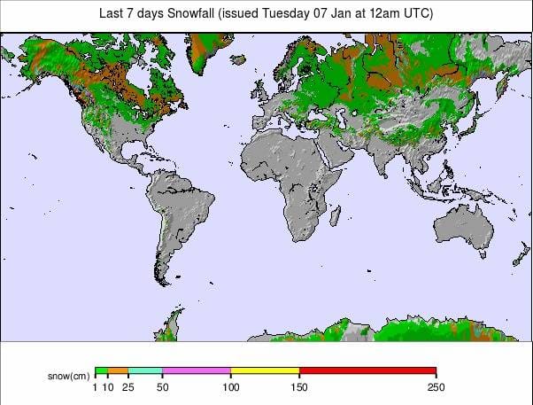
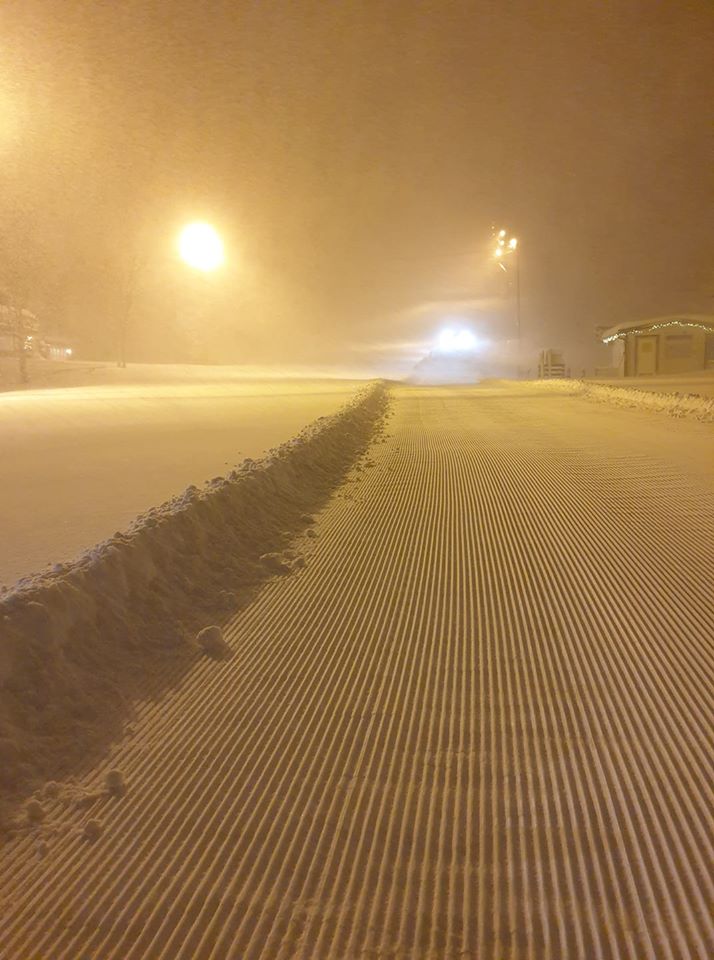
The big news for North America over the past week has really been the big snowfalls in the Northwest which have moved resorts in the region, which were languishing at the bottom of the snow depth table for the continent and struggling to open for lack of snow cover after a warm wet autumn, right up to the top of the table in just a few weeks. Elsewhere, conditions remain pretty good in the Rockies with low temperatures, decent snow depths in most areas and some fresh pow. The Midwest is continuing its battles for weather stability as temperatures yoyo up and down above and below the seasonal norm and things are picking up further on the East Coast, after the freezing rain problems a little over a week ago, with more normal wintery weather in most areas now.
USA
ROCKIES
ROCKIES REPORT| Although the heaviest snow since New Year has been measured a little further west, there’s been plenty in the Rockies too with 33” (83cm) for Snowbird in Utah (78/78” / 195/195cm) and 22” (55cm) at Steamboat in Colorado (46/55” / 115/137cm). Other areas in the region have also had fresh snow and most continue to report great conditions, with 6-12” (15-30cm) at many in the past 24 hours. With temperatures staying well below freezing from top to bottom of the runs in the mountains, it’s looking good for the coming week too.
ROCKIES FORECAST| There’s a little snow forecast for the Rocky Mountain region over the remainder of this week, but not a lot, just the odd inch or two here and there as a mixture of sunshine and clouds roll through the region. More snow ia likely further north. Temperatures are well below freezing for the week ahead almost everywhere in the mountains and could go as much as 25 below freezing high up at times, although generally more like 5-15 degrees below will be the norm.
WEST
USA WEST REPORT| It has been a snowy few days in the Northwestern US with Mt Baker (90/124″ / 224/310cm) moving to the top of the US and North American snow depth chart with just under five feet of snowfall (145cm) in 72 hours. It’s quite a turn-around in the region where several ski areas were delaying opening up to Christmas week because it was too warm and wet. But big snowfalls (if not quite so much as reported by what is, on average and in terms of all-time records, the world’s snowiest resort) have been reported by other ski areas in the region. It’s a different picture in the south of the region where resorts in California like Mammoth Mountain (47/87″ / 117/218cm) have been seeing much drier, sunnier weather.
USA WEST FORECAST|After a few days lull in the snowfall the next front is expected to hit the region at the end of this week and into the weekend with 1-2 foot (30-60cm) accumulations likely in the north of the area. The heaviest snowfall will again be up in the northwest but there should be significant snowfall as far south as Tahoe, though further south than that there’s currently just sunshine forecast.
MIDWEST
MIDWEST REPORT|Ski areas at most states in the Midwest are continuing to tread a tightrope between consistently cold weather, allowing them to run snow-making and open more terrain, and repeated warm fronts moving forward that set everything back. It has been more of the same this past week with most areas currently open, and most now with reasonable to good snow depth and most terrain open. But conditions have sometimes been too warm for great skiing.
MIDWEST FORECAST| Temperatures look set to continue to yoyo between well above freezing and well below in most of the Midwest as the region sees more warmer-than-seasonal-norm fronts move rapidly through. In between them double digits below freezing temps are closer to the seasonal norm. There’s not much fresh snow (a few inches); however, it’s good snow-making conditions.
EAST
USA EAST REPORT|A mixture of snowfall and sunshine in recent days in the Eastern US with some of the biggest falls of the winter so far in some areas and most seeing healthy dumps. Stowe (24/48″ / 60/120cm), in Vermont, reports the state’s deepest snow and has had 10” (25cm) in the past few days. Jay Peak (35/47” / 87/117cm) had an even bigger fall of 17 “ (43cm) in the same period. With low temperatures and fresh snow, it looks like full-on winter now across much of the region.
USA EAST FORECAST|Temperatures are on a bit of a roller coaster and may get more than 30 degrees below freezing at times. But as a warmer front comes through at the weekend, the temps will climb above freezing briefly. Heavy snowfall is expected with that front but at its warmest point, it may result in rain at times in some areas. But fingers crossed it all falls as snow.
CANADA
WEST
CANADA WEST REPORT| After plenty of snow in central and eastern BC and Alberta over the past few months it has finally been the turn of Coastal BC to really see some serious snowfall since the start of the new year and it is still dumping down there now. Whistler Blackcomb (170/170cm / 68/68″), which had suffered a very poor start to the season due to warm, wet weather, has enjoyed 609cm (2ft) of snow to start the week (the most in the region) and now has about a third of its runs open, up from just 10% in the run-up to Christmas. Across the region, it looks good though with more fresh snow further inland too (if not quite so much, but then resorts there have had plenty already).
CANADA WEST FORECAST|The heavy snow of the first week of January should see a lull of a day or two over Wednesday/Thursday before the next front moves in. This is expected to dump heavily on west coast resorts once again, with the potential of up to a metre more snowfall if it all lands as snow. There could be smaller but still significant accumulations further inland. Moving through the weekend and into next week snow showers should continue but be lighter.
EAST
CANADA EAST REPORT|Finally it appears to be an improving picture in Quebec and eastern Canada after the warm, wet end to last year and issues like freezing rain rather than snow between Christmas and New Year. Now it is finally properly cold and there have been significant snowfalls allowing closed areas to open and centres with little open to operate more. Tremblant (30/45cm / 12/187″), the biggest in the region, has had 15cm (6”) more snowfall in the past few days and now has about 80% of its slopes open. There was a similar snowfall at Mont Sainte Anne (25/25cm / 10/10″) which now has about half of its runs open.
CANADA EAST FORECAST|It should get increasingly wintery at last in eastern Canada over the remainder of this week and through the weekend with 300-60cm (1-2 ft) accumulations possible as temperatures remain well below freezing and a front moves in on Friday or Saturday.
INTRODUCTION EUROPE
Skiers have been reporting a second successive week of excellent conditions in much of western Europe. The enthusiasm is more muted in lower areas of Austria and Germany; however, where there has been less snow at progressively lower altitudes (to almost none at the lowest areas) and recent days have seen rain. So it is very much a question of where you are and, particularly, how high you are.
It’s actually ski areas in Scandinavia which have reported the most fresh snowfall in Europe since New Year’s Day, with some in western Norway reporting more than 50cm of fresh falling. The Tatra mountains of Slovakia, the Czech Republic and Poland, to the northeast to the continent, have also been reporting some decent dumps.
Elsewhere, the Pyrenees, Balkans and Dolomites have stayed largely dry and sunny whilst Scotland continues to battle poor conditions to start the season with temperatures getting up to double digits above freezing and the added problem of gale-force winds at the start of this week. The centres are still operating with small areas of snow, once the wind drops, thanks to their all-weather snow-making systems
AUSTRIA

AUSTRIA REPORT|It’s very much ‘a game of two halves’ in Austria with deep snow and some fresh snow falling up high and temperatures hitting double digits above freezing and rain showers on lower slopes. It’s all very different to a year ago when the country was being buried by massive snowfalls that led to entire ski resorts being completely evacuated due to extreme avalanche danger. Against those two extremes, most of the country’s leading areas are fully open with all lifts running and all slopes open (more or less), with enough snow lying (or pushed down) on lower slopes to keep runs open even to low lying resorts. Fresh snow has been hard to find since the end of last year for free-riders but Solden (97/311cm / 39/124”) and Molltal (30/300cm / 12/120”) both reported 20cm (8”) of fresh snowfall over the past few days whilst it was raining down below.
AUSTRIA FORECAST|Austrian ski areas are seeing big temperature variations between double digits above freezing in the valleys in the middle of the day to double digits below freezing on the mountains at night. At other times valley temps dip below freezing at night and mountain temps get just above freezing mid-afternoon. There’s not much snowfall in the forecast at present, perhaps just a light band of snow bringing a few centimetres across the country at the start of the weekend, but otherwise more of the same is expected.
SWITZERLAND

SWITZERLAND REPORT|It has been another glorious, mostly sunny week on Swiss slopes to start 2020, with little or no fresh snowfall reported. Unusually for January, the base depths reported by the resort with the deepest snow in the country (and in Europe and indeed the world at present), Andermatt (38/400cm / 15/160″), are actually down slightly on last week so there has been a bit of a thaw, or settling, or they just took a fresh measurement. As with the rest of the Alps the snow cover, now a fortnight old, is getting hard-packed and there’s not much powder left to be found off-piste but the groomed slopes are almost open with great conditions.
SWITZERLAND FORECAST|In Switzerland, as with the rest of the Alps, we have a fairly stable weather forecast for the week ahead, mostly with just the outside chance of a few snowflakes possibly adding up to a few centimetres of fresh snow on higher slopes as we head into the weekend. The temperature should hover around freezing across the country’s ski areas, climbing a little above in the daytime and a little below at night with ski areas below 1500m seeing the warmer temps.
FRANCE
FRANCE REPORT|Conditions remain pretty excellent across French ski slopes with a second week of largely sunny weather. There’s been little fresh snowfall to speak of since New Year so the hope of finding much off-piste powder is diminishing, but in terms of groomed runs almost everyone in the country is currently open, every lift operating and every major ski area has the snow lying at least a metre (40 inches) deep on upper runs, some nearly 3 metres deep (10 feet). Bonneval sur Arc (140/290cm / 56/116”) over the back of Val d’Isere is reporting the deepest snow in the country with Montgenèvre (230/280cm / 92/112″) not far behind and one of the few ski areas in the world to report a 2 metre (80 inch) base at resort level too.
FRANCE FORECAST|It looks like a third week of sun ahead for most of the French mountains with the exception of an end-of-week snow front coming through which may deposit between 5 and 20cm of fresh snow to top up cover on Friday/Saturday. Temperatures have been hovering around freezing from resort level up to higher slopes and have been getting to 5-6 degrees above freezing at lower altitude traditional resorts so thawing will continue there but should not be significant.
ITALY

ITALY REPORT|Italy has had a dry and generally sunny week like the rest of the Alps. Temperatures have been a little warm making the snow soft in places after an icy start and with temperatures climbing a little above zero there’s something of a spring skiing feel to it all. There’s no fresh snow reported in Italy this week but most areas are fully open with deep snow cover. Passo Tonale (40/400cm / 16/160”) still has the deepest snow in the country, Europe and (equal with Switzerland’s Andermatt) the world at present.
ITALY FORECAST|There’s, unfortunately, no fresh snow in the forecast in Italy with most areas set to get another week of wall to wall sunshine. Most have good bases so a little thawing (likely with temperatures above freezing up to about 2000 metres altitude) shouldn’t cause much damage. But those looking for off-piste fresh snow stashes will probably have to wait a while longer now.
SCANDINAVIA

SCANDINAVIA REPORT|Scandinavian ski areas saw the biggest snowfalls in Europe, particularly over the weekend, when some resorts reported up to 40cm (16”) of snow in 24 hours. Bjorli (70/80cm / 28/32″) in Norway reported the biggest accumulation and it was Norway in particular which saw the biggest snowfalls in the region. However, the snowfall has been widespread with Sweden’s Storlien (70/70cm / 28/28”) reporting 30cm (a foot) of snowfall in the same 24 hour period. Other resorts in the region have reported snowfalls leading to slightly smaller accumulations and temperatures have generally been a little below freezing with less intense, but ongoing snowfalls in recent days.
SCANDINAVIA FORECAST|It should stay largely snowy in Scandinavia with small to moderate snowfalls the norm most days over the week ahead in many regions; however, temperatures are set to swing quite dramatically between well above and well below freezing so it may be snowing one day then thawing a little the next. But, overall, conditions should stay good.
GERMANY

GERMANY REPORT|Much of Germany continues to suffer from warm conditions with precipitation often falling as rain instead of snow. That said, most of the country’s larger destination-sized ski resorts have got runs open thanks to December snowfall. The bases at open areas on lower slopes are typically 5-10cm (2-4”), 30-60cm (1-2ft) up high. The Fellhorn ski area (5/80cm / 2/32″) reports one of the biggest areas of German terrain open so far, 36km. Most bigger areas have less terrain actually skiable so far.
GERMANY FORECAST|Alas, there’s no marked improvement on the horizon on German ski slopes with the current forecast for more lovely sunny days with temperatures just above freezing in the mountains, a few degrees warmer down in resort. That’s pleasant if there’s already snow lying but for lower slopes and smaller, lower centres with nothing so far, it’s too warm for snowfall and for snow-making. There’s the chance of a few centimetres in Bavaria at the end of the week against the otherwise warm, dry trend.
BULGARIA and ROMANIA
BULGARIA / ROMANIA REPORT|We’ve continued with another week of almost fully sunny days in Bulgaria. But temperatures have held below freezing at most resorts, or just a few degrees above. Therefore, snow-making systems have been fired up whenever possible and although it’s all machine-made and bases still aren’t very exciting, Bansko (5/75cm / 2/30”) has managed to open pretty much all of its runs, including the long home run back from ski slopes to resort. The other Bulgarian areas have less of their terrain open but are otherwise in a similar position.
BULGARIA / ROMANIA FORECAST|There is no real change in the weather expected over south-eastern Europe over the coming week with wall-to-wall sun forecast and temperatures hovering around freezing point, a little below on the slopes, a little above in resort. So no fresh snow expected but it should be possible to do more snow-making and there shouldn’t be much thawing either.
CZECH REPUBLIC and SLOVAKIA
CZECH REPUBLIC / SLOVAKIA REPORT| Ski areas in the Czech and Slovak Republics have posted some of the biggest snowfalls in Europe over the past week, with Slovakia’s leading area, Jasna (30/70cm / 12/28″), reporting a 40cm (16”) accumulation in the past 72 hours. All the snow has led to greatly improved conditions. Although, as with all of Europe and the Northern Hemisphere at present, the best conditions are on higher slopes. Most areas in the region have between a third and two-thirds of their terrain open now following the slow start to the season with warm temperatures pre-Christmas.
CZECH REPUBLIC / SLOVAKIA FORECAST|The dry weather that is going to be prevalent over most of Europe for the coming week looks set to hang over the Czech and Slovak republics too with sunshine before and after the weekend; however, cloudier conditions are forecast from Friday to Sunday and possibly a few snowflakes. Temperatures should stay sub-zero on the mountains all week allowing snow-making systems to operate but it will climb in to plus temps in the valleys at times.
SPAIN and ANDORRA
SPAIN / ANDORRA REPORT|It has been a largely sunny week in the Pyrenees again and there’s really little change in the picture from a week ago and indeed a fortnight ago, that is most ski areas fully open. Temperatures are a little too warm, generally a few degrees above freezing. In Andorra, Arcalis (30/110cm / 12/44”) has the deepest base whilst the region’s biggest ski area, Grandvalira (30/70cm), has all but a handful of its nearly 130 runs open. Some fresh snow and slightly lower temperatures would be nice.
SPAIN / ANDORRA FORECAST|There’s little sign of any significant change ahead for ski areas in Spain and the Pyrenees with another week of sunshine and slightly-too-warm temperatures a little above freezing in the forecast. The end of this week may see a few centimetres of snow with a front moving in and temperatures set to dip into negative territory. But it currently looks like it will be short-lived.
SCOTLAND

SCOTLAND REPORT| Scotland is still not seeing the real start of winter but, thanks to all five ski area now operating all-weather snow-making centres, the country’s resorts are still open for limited snow-sports. This is despite temperatures getting into double digits above freezing earlier this week. What did stop some centres operating were extreme gale-force winds on Tuesday, along with torrential rain, which closed most areas temporarily. The Lecht (0/10cm / 0/4”) closed its small area to preserve its pile of snow from the elements, saying spreading it out on the slopes would mean it would disappear quicker with the warm temperatures, wind and rain.
SCOTLAND FORECAST|It’s another mixed bag for the week ahead in the Scottish Highlands and a rapidly changing picture. Temperatures should drop to end the week and there’s the chance of fresh hill snow. But, currently, it looks like temperatures will rise again into the weekend with the chance of more strong winds. So, there’s still no sign of the arrival of a proper winter in the region.
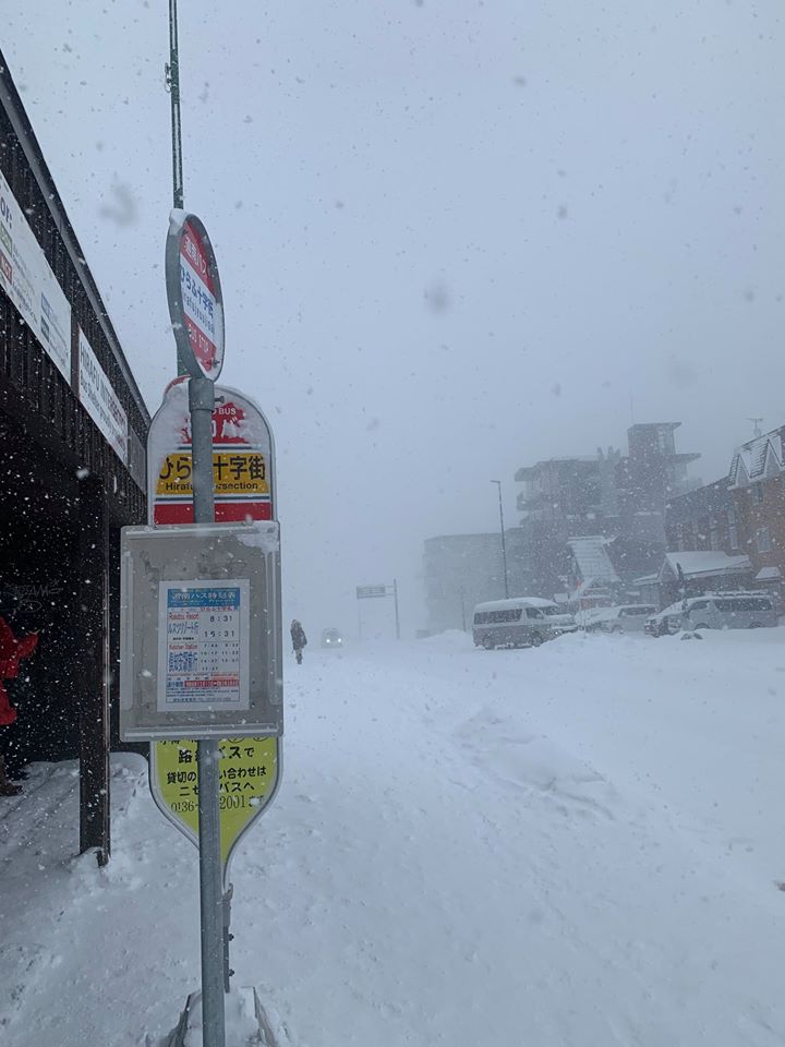
JAPAN
JAPAN REPORT|Niseko (80/210cm / 32/84”) has had more snow in the first week of 2020 than it did in the first week of the previous two years. So that’s hopefully a good sign after the warm, wet autumn set ski areas in Japan behind schedule in building bases, opening terrain and providing their famous powder. The resort has received 86cm (nearly 3 feet) of snow in the past week. Niseko is publishing some of the better numbers though and big resorts to the south like Hakuba (75/120cm / 30/48”) have had less snow and are still struggling to open terrain, particularly on lower slopes.
JAPAN FORECAST|Despite some good snowfalls over the past fortnight Japan’s ski season is still not firing on all cylinders. Temperatures have warmed up again and unfortunately, some precipitation has again been falling as rain when it would normally be snow. Things look like they should cool down again into the weekend with some significant snowfall possible, although light snow is more likely for most areas.


