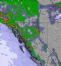
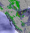
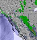
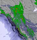
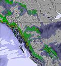
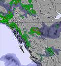
The above table gives the weather forecast for Turner Mountain at the specific elevation of 1492 m. Our sophisticated weather models allow us to provide snow forecasts for the top, middle and bottom ski stations of Turner Mountain. To access the weather forecasts for the other elevations, use the tab navigation above the table. For a wider view of the weather, check out the Weather Map of United States.
Click here to read further information on freezing levels and how we forecast our temperatures.
Great unknown mountain.
Had heard about this place through the underground powder reports. Drove in from a ski trip from Schweitzer to find that it had snowed about 18 inches on the road and it was only plowed to within 10 miles and after that it was definitely 4x4 only. Upon arrival there were only about 100 people on the mountain and over 2 feet of fresh snow. The people were great, very friendly and wanting to show off there mountain to a bunch of Canadian ski patrollers. The one and only double chair was reliable and gave great access to some wonderful terrain for powder skiing. Direct fall line skiing with a good pitch. Spent the morning skiing the front side and barely had to ever cross another track. In the afternoon we went over the back side and had a blast in the gladed tree runs that were virtually untouched. Although we hit it on a spectacular powder day we could certainly see how this place would be great even if it didn't have a fresh dump. Definitely worth a stop if you are travelling in this area but it is very unknown and somewhat difficult to get into on a big powder day. A true community ski hill.
Free Snow-Forecast.com weather widget for your website
Embed the Turner Mountain weather widget on your site for free. It provides a weekly snapshot of snow and rain conditions across all elevations. Follow the two quick steps to grab your custom code and paste it into your site. Choose between metric or imperial units. Click here to get the code.


 Nearest