

A New Largest Ski Area in New Zealand?
The Remarkables is hoping to overtake Cardrona as New Zealand’s largest ski area under a major NZD 150 million‑plus expansion proposal lodged by owner NZSki.

Next 3 days weather summary:Heavy rain (total 43.0mm), heaviest during Fri night. Warm (max 23°C on Fri morning, min 15°C on Thu night). Wind will be generally light. | Days 4-6 weather summary:Heavy rain (total 30.0mm), heaviest during Sun afternoon. Warm (max 24°C on Tue afternoon, min 14°C on Mon night). Wind will be generally light. | |||||||||||||||||
Thursday 25 | Friday 26 | Saturday 27 | Sunday 28 | Monday 29 | Tuesday 30 | |||||||||||||
AM | PM | night | AM | PM | night | AM | PM | night | AM | PM | night | AM | PM | night | AM | PM | night | |
t-storm risk | t-storm risk | rain shwrs | clear | t-storm risk | t-storm risk | clear | t-storm risk | rain shwrs | t-storm risk | t-storm risk | heavy rain | t-storm risk | t-storm risk | rain shwrs | t-storm risk | some clouds | clear | |
km/h | ||||||||||||||||||
Snow map |  |  |  |  |  |  | ||||||||||||
— | — | — | — | — | — | — | — | — | — | — | — | — | — | — | — | — | — | |
mm | 1 | 6 | 8 | — | 5 | 11 | — | 5 | 7 | 1 | 7 | 11 | 2 | 3 | 4 | 2 | — | — |
max °C | 22 | 21 | 18 | 23 | 21 | 18 | 23 | 23 | 19 | 23 | 23 | 19 | 23 | 20 | 18 | 23 | 24 | 20 |
min °C | 19 | 21 | 15 | 18 | 21 | 15 | 19 | 22 | 15 | 19 | 23 | 15 | 18 | 19 | 14 | 19 | 24 | 15 |
chill °C | 19 | 21 | 15 | 18 | 21 | 15 | 19 | 22 | 15 | 19 | 23 | 15 | 18 | 19 | 14 | 19 | 24 | 15 |
Humid % | 59 | 65 | 75 | 53 | 68 | 78 | 56 | 70 | 76 | 53 | 59 | 84 | 49 | 66 | 76 | 43 | 39 | 56 |
Freeze m | 4300 | 4450 | 4350 | 4300 | 4550 | 4500 | 4450 | 4650 | 4600 | 4500 | 4550 | 4500 | 4400 | 4450 | 4350 | 4200 | 4400 | 4300 |
5:20 | — | — | 5:22 | — | — | 5:22 | — | — | 5:22 | — | — | 5:22 | — | — | 5:22 | — | — | |
— | — | 9:07 | — | — | 9:07 | — | — | 9:07 | — | — | 9:07 | — | — | 9:07 | — | — | 9:07 | |
Go pro and carve into:
Avalanche information: European Avalanche Warning Services (EAWS)
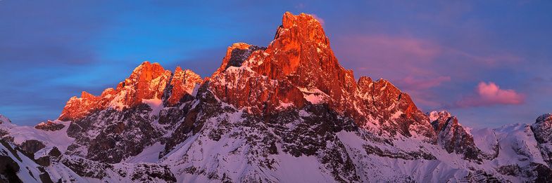
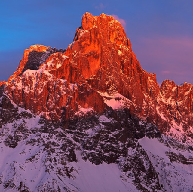
Latest snow reports near San Martino Di Castrozza:
| Top snow depth: | 0 cm |
|---|---|
| Bottom snow depth: | 0 cm |
| Fresh snowfall depth: | — |
| Last snowfall: | 16 May 2026 |
| Snow Alerts | Create Alert |
0.0 | Bluebird Powder days Fresh snow, mostly sunny, light wind. |
|---|---|
0.0 | Powder days Fresh snow, limited sun, any wind. |
0.0 | Bluebird days Average snow, mostly sunny, light wind. |
The above table gives the weather forecast for San Martino Di Castrozza at the specific elevation of 1450 m. Our sophisticated weather models allow us to provide snow forecasts for the top, middle and bottom ski stations of San Martino Di Castrozza. To access the weather forecasts for the other elevations, use the tab navigation above the table. For a wider view of the weather, check out the Weather Map of Italy.
Click here to read further information on freezing levels and how we forecast our temperatures.
Overall 4.0 Based on 14 votes and 1 review
I am stunned that fewer non Italians visit here. Scenery is staggering, a good ski area with a variety of runs. A lot of you include Passo Rolle, great hotels. I am writing from the excellent Regina, a town with shops, bars, cafes and super restaurants. All this at half..no exaggeration of the cost of Cortina or Selva. A bargain.
Walter from Switzerland writes:
I am stunned that fewer non Italians visit here. Scenery is staggering, a good ski area with a variety of runs. A lot of you include Passo Rolle, great hotels. I am writing from the excellent Regina, a town with shops, bars, cafes and super restaurants. All this at half..no exaggeration of the cost of Cortina or Selva. A bargain.
Click here to submit your own review of San Martino Di Castrozza


 Nearest