

A New Largest Ski Area in New Zealand?
The Remarkables is hoping to overtake Cardrona as New Zealand’s largest ski area under a major NZD 150 million‑plus expansion proposal lodged by owner NZSki.

Next 4 days weather summary:Light rain (total 5.0mm), mostly falling on Wed night. Warm (max 24°C on Fri afternoon, min 19°C on Wed night). Wind will be generally light. | Days 5-7 weather summary:Light rain (total 2.0mm), mostly falling on Sun night. Warm (max 26°C on Sun afternoon, min 19°C on Mon night). Winds increasing (calm on Sun morning, fresh winds from the NNW by Mon night). | |||||||||||||||
Thursday 25 | Friday 26 | Saturday 27 | Sunday 28 | Monday 29 | ||||||||||||
night | AM | PM | night | AM | PM | night | AM | PM | night | AM | PM | night | AM | PM | night | |
rain shwrs | clear | clear | clear | clear | clear | clear | clear | clear | clear | clear | clear | rain shwrs | some clouds | clear | clear | |
km/h | ||||||||||||||||
Snow map |  | 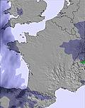 | 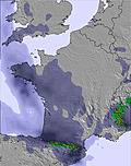 | 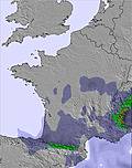 | 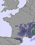 |  | ||||||||||
— | — | — | — | — | — | — | — | — | — | — | — | — | — | — | — | |
mm | 5 | — | — | — | — | — | — | — | — | — | — | — | 2 | — | — | — |
max °C | 22 | 20 | 22 | 22 | 22 | 24 | 24 | 21 | 24 | 23 | 20 | 26 | 25 | 21 | 25 | 24 |
min °C | 19 | 19 | 22 | 20 | 21 | 24 | 21 | 21 | 23 | 20 | 20 | 24 | 20 | 20 | 25 | 19 |
chill °C | 19 | 19 | 22 | 20 | 21 | 24 | 21 | 21 | 23 | 20 | 20 | 24 | 20 | 20 | 25 | 19 |
Humid % | 50 | 55 | 46 | 36 | 41 | 37 | 36 | 45 | 39 | 37 | 57 | 40 | 62 | 59 | 35 | 53 |
Freeze m | 4400 | 4400 | 4500 | 4500 | 4500 | 4600 | 4700 | 4650 | 4700 | 4700 | 4650 | 4400 | 4450 | 4300 | 4400 | 4300 |
— | 6:03 | — | — | 6:03 | — | — | 6:03 | — | — | 6:03 | — | — | 6:03 | — | — | |
— | — | — | 9:32 | — | — | 9:32 | — | — | 9:32 | — | — | 9:32 | — | — | 9:32 | |
Go pro and carve into:
Avalanche information: European Avalanche Warning Services (EAWS)
Latest snow reports near Prat Peyrot / Mont Aigoual:
| Top snow depth: | — |
|---|---|
| Bottom snow depth: | — |
| Fresh snowfall depth: | — |
| Last snowfall: | 14 May 2026 |
| Snow Alerts | Create Alert |
0.0 | Bluebird Powder days Fresh snow, mostly sunny, light wind. |
|---|---|
0.0 | Powder days Fresh snow, limited sun, any wind. |
0.0 | Bluebird days Average snow, mostly sunny, light wind. |
The above table gives the weather forecast for Prat Peyrot / Mont Aigoual at the specific elevation of 1290 m. Our sophisticated weather models allow us to provide snow forecasts for the top, middle and bottom ski stations of Prat Peyrot / Mont Aigoual. To access the weather forecasts for the other elevations, use the tab navigation above the table. For a wider view of the weather, check out the Weather Map of France.
Click here to read further information on freezing levels and how we forecast our temperatures.


 Nearest