

Global Weekly Snow Roundup #320
Weekly Snow News for the world, updated 25 June 2026: Chile and New Zealand's seasons proper set to begin, Tignes and Sunshine reopen for summer skiing. weekend as Riksgransen ends its 2026 season.

Next 4 days weather summary:Some drizzle, heaviest during Sun afternoon. Warm (max 27°C on Sat afternoon, min 16°C on Thu night). Wind will be generally light. | Days 5-7 weather summary:Moderate rain (total 19.0mm), heaviest on Sun night. Warm (max 23°C on Mon afternoon, min 8°C on Tue night). Wind will be generally light. | |||||||||||||||
Friday 26 | Saturday 27 | Sunday 28 | Monday 29 | Tuesday 30 | ||||||||||||
night | AM | PM | night | AM | PM | night | AM | PM | night | AM | PM | night | AM | PM | night | |
clear | clear | clear | clear | clear | clear | clear | some clouds | t-storm risk | rain shwrs | clear | t-storm risk | rain shwrs | t-storm risk | rain shwrs | cloudy | |
km/h | ||||||||||||||||
Snow map | 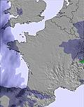 | 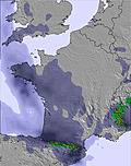 | 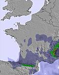 | 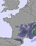 |  |  | ||||||||||
— | — | — | — | — | — | — | — | — | — | — | — | — | — | — | — | |
mm | — | — | — | — | — | — | — | — | 1 | 9 | — | 2 | 3 | 3 | 2 | — |
max °C | 23 | 24 | 26 | 24 | 25 | 27 | 25 | 24 | 27 | 19 | 21 | 23 | 18 | 16 | 17 | 13 |
min °C | 16 | 18 | 26 | 16 | 18 | 27 | 17 | 19 | 25 | 12 | 16 | 21 | 13 | 15 | 16 | 8 |
chill °C | 16 | 18 | 26 | 16 | 18 | 27 | 17 | 19 | 25 | 12 | 16 | 21 | 13 | 15 | 16 | 7 |
Humid % | 54 | 41 | 31 | 48 | 32 | 26 | 48 | 37 | 44 | 68 | 55 | 65 | 87 | 86 | 87 | 93 |
Freeze m | 4500 | 4450 | 4600 | 4600 | 4550 | 4700 | 4600 | 4550 | 4600 | 4350 | 4150 | 4400 | 4450 | 4200 | 4250 | 4250 |
— | 6:22 | — | — | 6:22 | — | — | 6:22 | — | — | 6:22 | — | — | 6:24 | — | — | |
— | — | — | 9:40 | — | — | 9:40 | — | — | 9:40 | — | — | 9:40 | — | — | 9:40 | |
Go pro and carve into:
Avalanche information: European Avalanche Warning Services (EAWS)
Latest snow reports near Piau Engaly:
| Top snow depth: | 0 cm |
|---|---|
| Bottom snow depth: | 0 cm |
| Fresh snowfall depth: | — |
| Last snowfall: | 15 May 2026 |
| Snow Alerts | Create Alert |
0.0 | Bluebird Powder days Fresh snow, mostly sunny, light wind. |
|---|---|
0.0 | Powder days Fresh snow, limited sun, any wind. |
0.0 | Bluebird days Average snow, mostly sunny, light wind. |

The above table gives the weather forecast for Piau Engaly at the specific elevation of 1420 m. Our sophisticated weather models allow us to provide snow forecasts for the top, middle and bottom ski stations of Piau Engaly. To access the weather forecasts for the other elevations, use the tab navigation above the table. For a wider view of the weather, check out the Weather Map of France.
Click here to read further information on freezing levels and how we forecast our temperatures.
Overall 3.5 Based on 29 votes and 4 reviews
Ol Esquiei nesta estância 3 anos seguidos, devo dizer que adorei, é fantástica...excelente neve, excelente tratamento de pistas e muito importante ainda, tem zonas dificeis como zonas ideais para aprendizagem de desportos de neve como o esqui e snowboard. Esta estancia é também ideal para o freeride, já que tem muitas zonas de neve virgem e de excelente qualidade, relativamente aos "forfaits", esta estancia oferece preços extremamente competitivos e ainda mais para estudantes, deixando a concorrência sem meios para competir. Mas como não há bela sem senão, tenho 1 reparo a fazer, na minha opinião é inconcebivel as pessoas que se localizam na venda de "forfaits" não terem conhecimentos básicos de inglês, idioma universal e "obrigatório" em regiões turisticas. Devido a todos estes factores aconselho a visitarem esta estância, tenho a certeza que vão gostar. Saudações desportivas
Hugo Oliveira from Portugal writes:
Ol
Esquiei nesta estância 3 anos seguidos, devo dizer que adorei, é fantástica...excelente neve, excelente tratamento de pistas e muito importante ainda, tem zonas dificeis como zonas ideais para aprendizagem de desportos de neve como o esqui e snowboard. Esta estancia é também ideal para o freeride, já que tem muitas zonas de neve virgem e de excelente qualidade, relativamente aos "forfaits", esta estancia oferece preços extremamente competitivos e ainda mais para estudantes, deixando a concorrência sem meios para competir. Mas como não há bela sem senão, tenho 1 reparo a fazer, na minha opinião é inconcebivel as pessoas que se localizam na venda de "forfaits" não terem conhecimentos básicos de inglês, idioma universal e "obrigatório" em regiões turisticas.
Devido a todos estes factores aconselho a visitarem esta estância, tenho a certeza que vão gostar.
Saudações desportivas


 Nearest