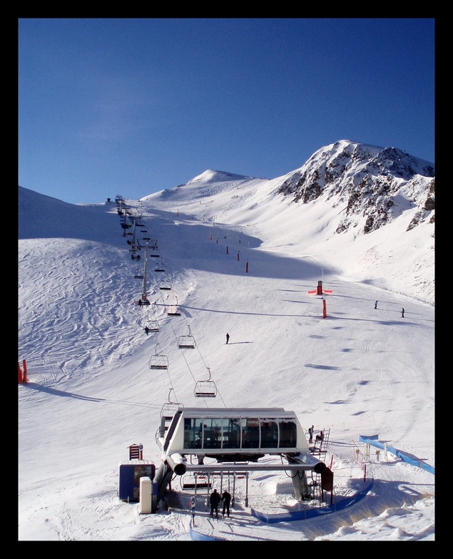


Portillo Storm Snowfall Total Passes 5m / 17 Feet
A snow storm that has now continued for nine days has taken Chilean ski resort Portillo to a snowfall total of 5.2 metres (17 feet) so far, with more snow forecast.

Next 3 days weather summary:Light rain (total 5.0mm), mostly falling on Fri night. Warm (max 21°C on Wed afternoon, min 13°C on Fri night). Wind will be generally light. | Days 4-6 weather summary:Mostly dry. Very mild (max 19°C on Sun afternoon, min 12°C on Mon night). Wind will be generally light. | |||||||||||||||||
Wednesday 29 | Thursday 30 | Friday 31 | Saturday 1 | Sunday 2 | Monday 3 | |||||||||||||
AM | PM | night | AM | PM | night | AM | PM | night | AM | PM | night | AM | PM | night | AM | PM | night | |
clear | some clouds | clear | clear | clear | clear | some clouds | cloudy | rain shwrs | clear | clear | clear | clear | clear | clear | some clouds | some clouds | clear | |
km/h | ||||||||||||||||||
Snow map |  |  |  |  |  |  | ||||||||||||
— | — | — | — | — | — | — | — | — | — | — | — | — | — | — | — | — | — | |
mm | — | — | — | — | — | — | — | — | 5 | — | — | — | — | — | — | — | — | — |
max °C | 18 | 21 | 20 | 19 | 20 | 19 | 18 | 20 | 17 | 16 | 17 | 16 | 18 | 19 | 18 | 16 | 17 | 15 |
min °C | 15 | 20 | 16 | 16 | 20 | 16 | 16 | 19 | 13 | 14 | 17 | 14 | 15 | 19 | 15 | 15 | 17 | 12 |
chill °C | 15 | 20 | 15 | 15 | 20 | 16 | 14 | 19 | 11 | 12 | 17 | 13 | 14 | 19 | 14 | 14 | 16 | 10 |
Humid % | 31 | 31 | 43 | 33 | 36 | 51 | 37 | 37 | 61 | 45 | 47 | 51 | 37 | 32 | 50 | 35 | 40 | 52 |
Freeze m | 4900 | 5050 | 4900 | 4750 | 5000 | 4800 | 4750 | 4850 | 4800 | 4650 | 4800 | 4850 | 4850 | 4950 | 4850 | 4650 | 4700 | 4550 |
6:45 | — | — | 6:46 | — | — | 6:47 | — | — | 6:48 | — | — | 6:48 | — | — | 6:50 | — | — | |
— | — | 9:22 | — | — | 9:21 | — | — | 9:20 | — | — | 9:19 | — | — | 9:17 | — | — | 9:16 | |
Go pro and carve into:
Avalanche information: European Avalanche Warning Services (EAWS)
Latest snow reports near Peyragudes:
| Top snow depth: | 0 cm |
|---|---|
| Bottom snow depth: | 0 cm |
| Fresh snowfall depth: | — |
| Last snowfall: | 15 May 2026 |
| Snow Alerts | Create Alert |
0.0 | Bluebird Powder days Fresh snow, mostly sunny, light wind. |
|---|---|
0.0 | Powder days Fresh snow, limited sun, any wind. |
0.0 | Bluebird days Average snow, mostly sunny, light wind. |
The above table gives the weather forecast for Peyragudes at the specific elevation of 2400 m. Our sophisticated weather models allow us to provide snow forecasts for the top, middle and bottom ski stations of Peyragudes. To access the weather forecasts for the other elevations, use the tab navigation above the table. For a wider view of the weather, check out the Weather Map of France.
Click here to read further information on freezing levels and how we forecast our temperatures.
Overall 3.9 Based on 21 votes and 13 reviews
Station très agréable, familiale. Les canons à neige permettent un bon enneigement. Le soleil est souvent au rendez vous. Je recommande !! Et j'y retournerai dès que possible.
Catherine from France writes:
Station très agréable, familiale. Les canons à neige permettent un bon enneigement. Le soleil est souvent au rendez vous.
Je recommande !! Et j'y retournerai dès que possible.


 Nearest